
When I was a little squirt, my family would take holiday trips from Los Alamos to St. George. It was a long day’s drive. Punctuated only by a few gas stops with rushed potty breaks. Dad would burn up the miles, road map at hand. My brothers would mark the distance traveled by identifying the various landmarks along the way. They would rattle off names of roadside attractions and distant faded mountains. I learned to find my way to Grandma’s house using landmarks, rather than the numbers and colored lines on a map.
Past Huerfano in the Rio Grande Valley, then through O’Keeffe country along the Rio Chama. Passing small Pueblo communities and Hispanic towns with homes the colors of native soil. South at Pedernal, then through the mixed open forests and range lands west of the Jemez Mountains.
Across the Navajo Nation, with pale yellow sandstone. Thru Pinions, Junipers and Sage. There would be an occasional Hogan miles from their nearest neighbor. Pickups a plenty, with families in the back. Shiprock would appear as a distant phantom, deepen on approach to a rich brown, then fade again once past.
Heading south of Kayenta, we’d often take a break at the Elephant’s feet. Thru stark painted desert past Tuba City, then north again. Hugging a long stretch of sandstone cliffs. The north-east boundary of the Grand Canyon. Across the Colorado at Marble Canyon Bridge and west again in the shadow of the Vermillion Cliffs. At Fredonia, we’d either head north through the canyons and turrets of Zions. Or west past Canaan Mountain. Arriving in St. George late in the day. After a few days visiting Grandma, we would reverse the route, headed home.
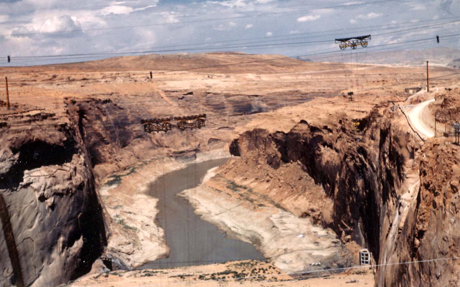
My Dad had read about the project to build Glen Canyon Dam. The next trip, we turned up a road that climbed through the cliffs east of Marble Canyon. On top, an expansive panorama spread in all directions. We drove past the new town of Page, following signs to a public viewpoint.
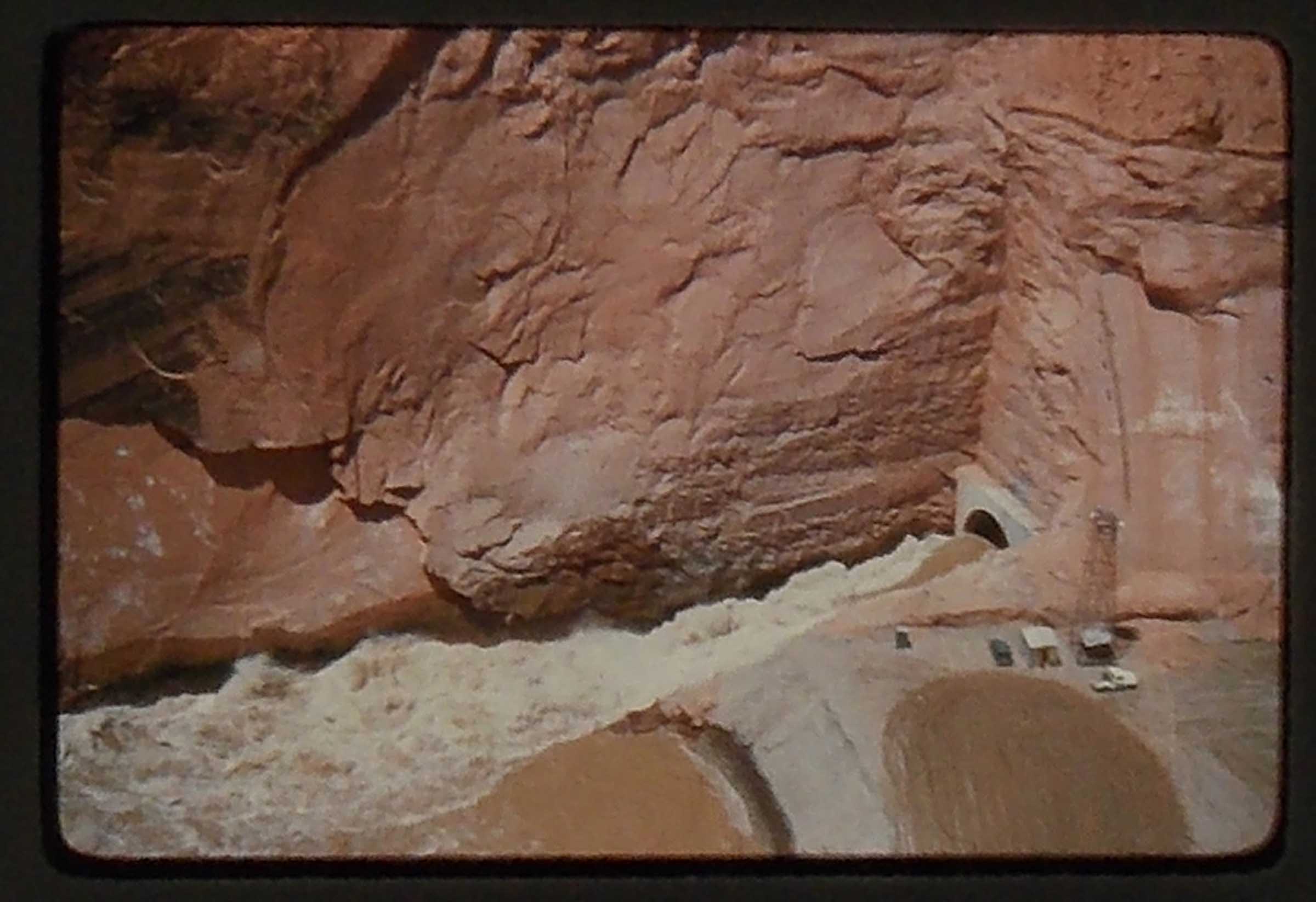
The construction area was massive. Large buildings of gray corrugated steel. A multitude of cables stretched across the canyon. Held at either end by huge towers. The west towers, in a notch, cut into the orange sandstone of Beehive Rock. The cables shuttled large hoppers of wet concrete. Lowering them to the growing base of the dam. There was a flurry of activity throughout the construction site. Trucks of all size and description. Workers busy at different tasks. For a budding Tonka Contractor, this was nirvana.
The arch of the bridge was far from joined. I looked at the workers on the steel, then down hundreds of feet into the canyon. “What if they fall?” I asked, feeling a Butterfly or two. Dad pointed out the heavy netting strung below the bridge workers.
Beehive Rock really caught my attention. I wondered why they couldn’t have just moved everything one way or the other and leave the unique feature intact.
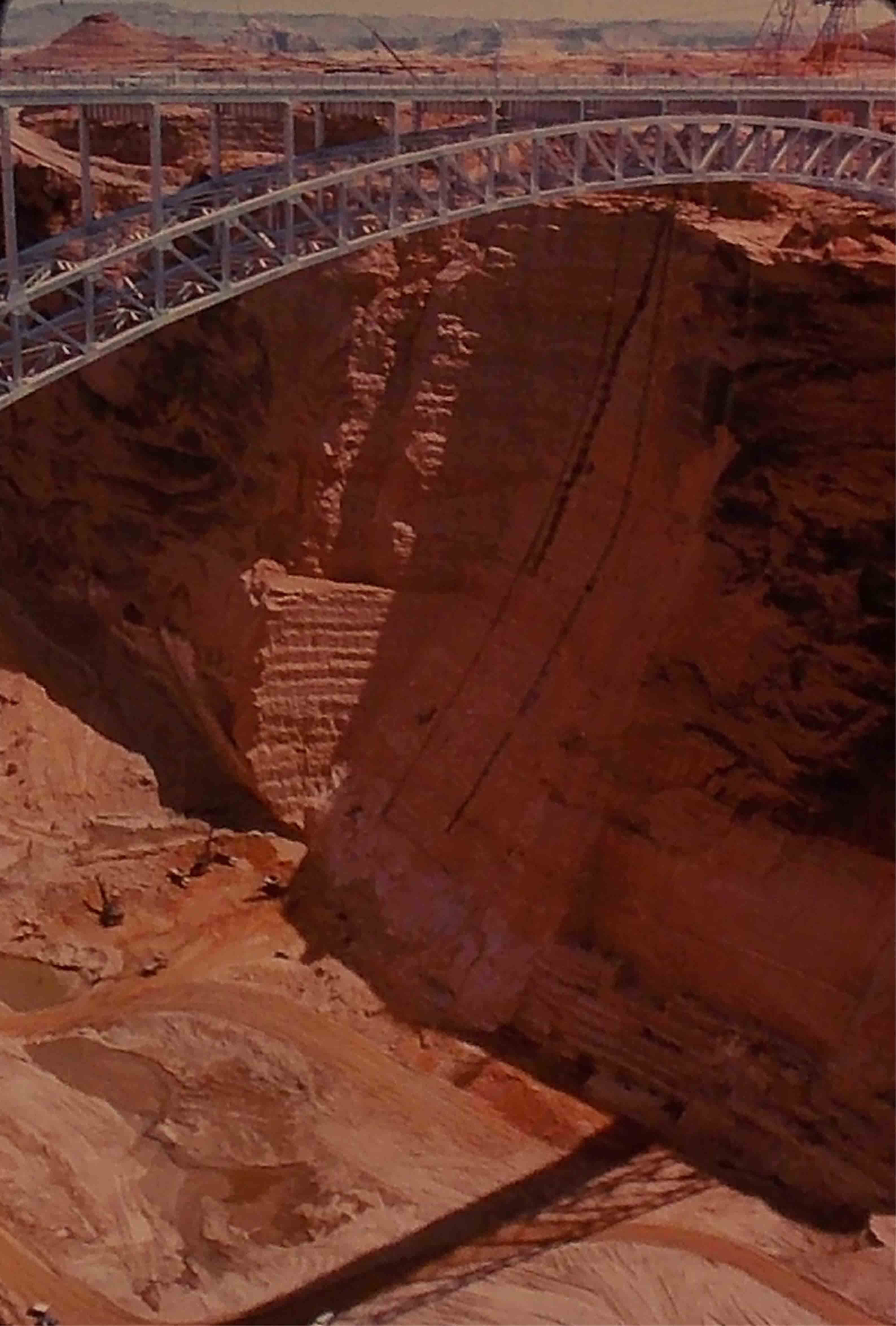
The next visit, the arch of the bridge was complete. The horizontal structure closing fast. A docent told us of three tunnels, cut into the sandstone. One to access the base of the dam. The other two, allowed the Colorado River waters to bypass the coffer dam. Without a way to transfer heat from the drying concrete, it would take a hundred years for the dam to cool. The answer was to run cold water through pipes that were buried as concrete was poured. The dam rose in segments like a giant 3-D puzzle.
Eventually, the bridge was completed and opened to the public. A new highway bee-lined westward to Kanab. Dad’s new favorite seemed shorter, and picked up a new set of landmarks.
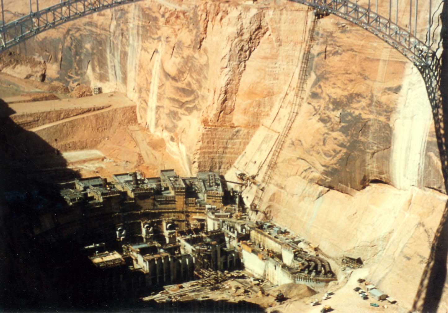
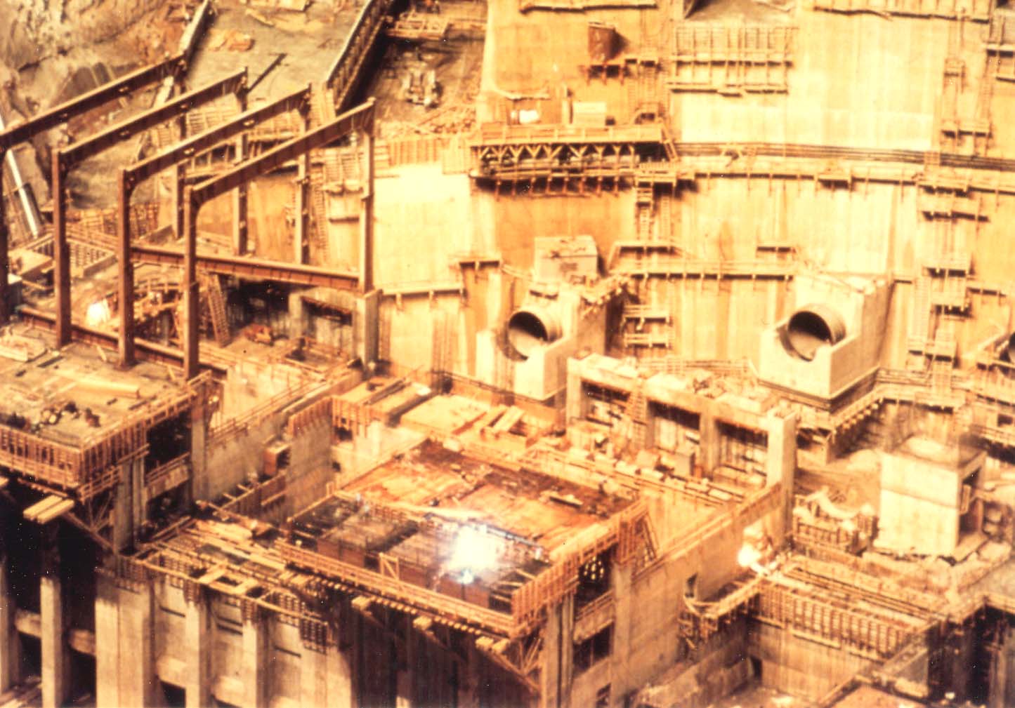
Years passed and the dam grew to its completion. The water level rose, stretching to the north. I never got tired of touring the dam. The over-sized structures and machinery were pretty impressive. I loved hanging my head off either side to look down the face. I remember craning my neck, outside the generator building, studying the dam and bridge stretching above. Buzzing of high voltage nearby.
My Uncle Mark moved to Page. His home was on the west side of town where the hill overlooked Glen Canyon. He never had a boat or even a canoe. We spent more time at the dinner table than exploring the lake.
Our cousins took my brother and I on a hike downstream from the dam. We descended into the canyon on a slick-rock trail. At the steeper sections, steel cables were placed for handholds. We watched large Trout swim past in the clear water. A few fishermen had come up from Lee’s Ferry in small boats. It was hot and I wanted to hop into the river to cool off. My cousin insisted that I only cool my feet. They soon throbbed from the icy water.
On one visit, my Uncle’s neighbor had a contract to lay a slab of concrete for the expanding visitors center. He needed a crew to spread the pour. My Uncle was in his 70’s and the rest of us recruits were wimpy non laborers. Big mistake! The ‘Federal spec.’ concrete was fast setting, and would dry as hard as granite. The contractor was in a panic as we nearly lost the foot-deep pour.
When the Navajo power plant was built, we tried a new road. It ran partly aside the rail line from the Peabody Coal Mine, south of Kayenta. The long jog south past Tuba City was traded for broad Sage plains and a distant view of Navajo Mountain. I recall seeing Navajo women in traditional velvet dresses. Tending flocks of Churro Sheep, as we sped past.
One Summer, our Explorer post went to Lake Powell to water ski. We set up camp on Lone Rock Beach. Then spent much of the week vegging out in the shade of a makeshift awning. In the morning, and late afternoon, the water would smooth to glass. We’d furiously take turns skiing. While changing skiers, I’d sit in the rocking boat, watching the colors reflected on the surface. I recall one dash across Wahweap bay, as a storm closed in. The boat’s hull slamming pale green waves. We found some fine places to cliff dive. But, I’d struggle to launch off even the lowest.
Late one Fall, my Uncle Mark, a friend Brent, and I were surveying a canyon north of Zions. I woke at 2am with a nasty case of the Black Death. Soon, Brent was dealing with it also. Man, that was horrible stuff! A couple of hours later, exhausted, we crawled back into our bags. We woke to a foot of new snow, loaded our trucks and left.
With chains on, I broke trail through deep snow for twenty miles. Twin white rooster-tails rising from the front tires. Endless Deer tracks crossing our path. One of the epic drives of my life and I felt like death warmed over. We spent the next couple of days touring the dam and kicking back on Lone Rock Beach. It was off-season and the peaceful setting did a lot to revive us.
As dusk approached, we sat, gazing across the lake. Contrasting colors of sky and sandstone played on the still surface. “Davey, is this awesome or what?” Brent asked. “Yea, outstanding!” I’d shown him ‘my concrete’ earlier. “Just think, if Glen Canyon Dam lasts 500 years, a part of you will always be here.”
The colors shifted as the sun dropped lower. “Ya ever wish you’d seen all of that before the lake buried it?” I asked. “Hell yea, wish I could have run Glen Canyon too!” Brent responded grinning. “But, it’s gone, history, not coming back in our lives.” He added. We sat and talked till the lake was as dark as the ghost of the Colorado far below.
Brent is still a lucky guy who doesn’t loose sleep over things he can’t change. Me? I thrash around and try to look at both sides. Lake versus River? It was a ballsy decision to put a cork in it for 500 years. I doubt I’d choose to do that. I doubt I’d chose to drain Lake Powell either though. I flop around on the issue, but I’d rather not loose sleep over it. I pack around my own groover filled with unresolved attachments. Glen Canyon just isn’t one of ’em.
I’ve wanted to do a Sea-kayak trip at Powell for years. A friend, spent a few days this June, touring remote side-canyons in his Yak. “Dave, where we were at was Paradise!” “Solitude?”, I asked. “Intense!” “Was it a Wilderness setting?” “Very much so.” Imagine that, on a lake renown for it’s motorized recreation. I’ll keep that dream on the list, with time set aside for an afternoon climb to the top of Beehive Rock.
Glen Canyon Dam became another landmark on the journey from my hometown to my Fathers’. Over the last fifty years, much has changed along our route. It’s been decades since I’ve been to Page and Lake Powell. Even longer since I’ve made the drive from Los Alamos to St. George. As long as the landmarks are there, I’m sure I’ll find my way.
Dave Jarvis is a life-long Trailhugger with an appetite for distant horizons and wandering trails.
To read the PDF version of this article, click here.
Don’t forget the Zephyr ads! All links are hot!


Dave, You bring back many fond memories of traveling the various routs from New Mexico to Utah over the past fifty or so years. I’m sorry I didn’t get to see as much as you did. I did not get a chance too see the Glen Canyon Dan area.The southern Utah-Northern Arizona land scape is certainly some the prettiest in the world. I once flew in a small plane going west at a fairly low altitude just before sundown.There is no way to explain it. Uncle Val
Dave, What an adventure you had each time on your way to Grandma’s..Glad you had the experience. We did have some times to see some of the sights. We did see the dam and other things while we were on our way. Keith always wanted to see where “that” road would take us.
You have written about this in a very interesting way. Continue your writing about whatever sounds good. Erma Rae