


#10: The Edward Abbey Memorial Gravel/Dump at Arches National Park
#9: Lake Powell's Underwater Tailings Pile
#7: Site of the Last Indian War
#6: The Keystone Pit (not available in web edition)
#5: The Magical Mystery Bus (not available in web edition)
#2:The Canyonlands National Park Pinyon/Juniper Graveyard
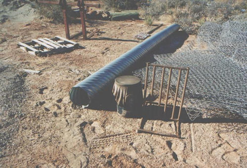 Just
a couple hundred feet from Arches National Park's picnic area and within
sight of Balanced Rock, sprawled over several acres of what was once pristine
national parkland lies--or oozes--the National Park Service's Most Scenic
Gravel and Waste Pit. The origins of the Arches Pit are sketchy, but this
grizzled ex-seasonal ranger can attest to its existence as far back as
1975. The junk yard continues to expand, year by year, inch by inch, as
it descends further into a sandy drainage that eventually makes its way
to Courthouse Wash, a few miles downstream.
Just
a couple hundred feet from Arches National Park's picnic area and within
sight of Balanced Rock, sprawled over several acres of what was once pristine
national parkland lies--or oozes--the National Park Service's Most Scenic
Gravel and Waste Pit. The origins of the Arches Pit are sketchy, but this
grizzled ex-seasonal ranger can attest to its existence as far back as
1975. The junk yard continues to expand, year by year, inch by inch, as
it descends further into a sandy drainage that eventually makes its way
to Courthouse Wash, a few miles downstream.
On the day we did the big phot o
shoot for this issue, we not only found the usual mounds of gravel and
asphalt, tons of discarded cut stone from the Windows Stone Stairway Project,
but also five gallon cans of thick viscous fluids, open cans of oil, a
hundred feet of cyclone fence, and a dozen steel fence posts that had
been placed in five gallon plastic buckets and filled with concrete.
o
shoot for this issue, we not only found the usual mounds of gravel and
asphalt, tons of discarded cut stone from the Windows Stone Stairway Project,
but also five gallon cans of thick viscous fluids, open cans of oil, a
hundred feet of cyclone fence, and a dozen steel fence posts that had
been placed in five gallon plastic buckets and filled with concrete.
Ed Abbey lived in a small trailer, not far from the pit in the mid-1950s. Just a few years before his death Ed returned to the gravel pit and said, "When I die, if I live that long, I'd like to be buried under that gravel, if the Park Service would be so kind."
Lake Powell's Underwater Tailings Pile
Worried about the Atlas tailings pile near Moab? Hey, no problem. Just
flood the damn thing. When Glen Canyon was flooded by the Powell Reservoir
near Hite, the water covered piles of toxic uranium tailings. 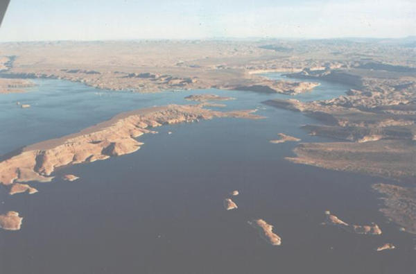
Water percolating through the tailings becomes contam-inated with radioactivity from Thorium-230, Radium-226 and Radon-222 left behind in the millings process. The tailings also contained high concen-trations of heavy metals including arsenic, barium, cadmium, lead, selenium, and vanadium. Health risks? Hey...Drink up!
The Bicycle Cemetery
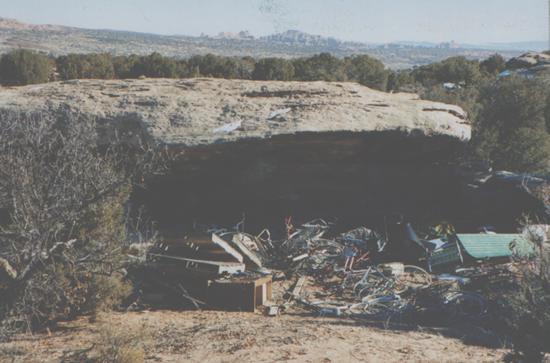
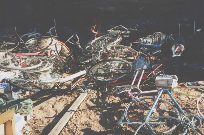 We have
NO IDEA what this is all about. Desert Mystic and Wanderer and Born Again
Baptist Carl Rappe led The Zephyr to this extraordinary Secret Place. He found
it one day as he wandered aimlessly near the Arches boundary in search of
cowboy camps. Instead he found this memorial to mountain bikers past, present
and future. What does it mean?
We have
NO IDEA what this is all about. Desert Mystic and Wanderer and Born Again
Baptist Carl Rappe led The Zephyr to this extraordinary Secret Place. He found
it one day as he wandered aimlessly near the Arches boundary in search of
cowboy camps. Instead he found this memorial to mountain bikers past, present
and future. What does it mean?
Site of the Last Indian War
Two decades into the 20th Century, tensions between white settlers and
Native Americans remained high in southeast Utah. Mormon ranchers in San
Juan County claimed that local Ute Indians, and particularly a man named
Posey and his band of "renegades, refused to respect their grazing
lands and did not "act like good Indians." The Utes countered
that whites were destroying native habitat. In 1923, two teenaged Utes convicted
of stealing a sheep escaped from the Bluff jail and raced to Blanding. Posey
and his followers met them there and the two groups fled into the canyons
together. 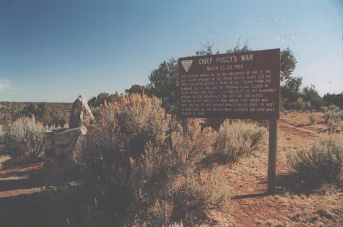 The
county commissioners wrote the governor for a plane load of machine guns
and the sheriff authorized his volunteer deputies "to shoot anything
that looks like an Indian." Posey was eventually shot and died from
his wounds after a long chase into the rugged country near Navajo Mountain.
One of the last armed conflicts between Whites and Native Americans was
over.
The
county commissioners wrote the governor for a plane load of machine guns
and the sheriff authorized his volunteer deputies "to shoot anything
that looks like an Indian." Posey was eventually shot and died from
his wounds after a long chase into the rugged country near Navajo Mountain.
One of the last armed conflicts between Whites and Native Americans was
over.
This location, just a stone's throw from the White Mesa Mill, marks the site of the second encounter between Posey and the deputies. One horse was killed and several of the combatants narrowly escaped death. For years, only a homemade and cryptic sign (above left) marked the site. Today a interpretive BLM sign, riddled with bullet holes, tells the sad story of Posey's Last War. (For an excellent account of Posey's War, see The Zephyr, Aug/Sep 1996, by Barry Scholl)
Rockworm Canyon
THE MOST INCREDIBLE CLIFF.... 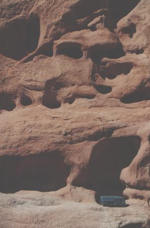
Is that Bob Castaldo's latest 4WD? An oil & gas thumper truck? A support vehicle for a Sierra Club outing? Whoever it is, they've found the spectacular rim of Rockworm Canyon, one of the best-kept secrets in SE Utah. Accessible by foot or vehicle, it's particularly spectacular at sunset.
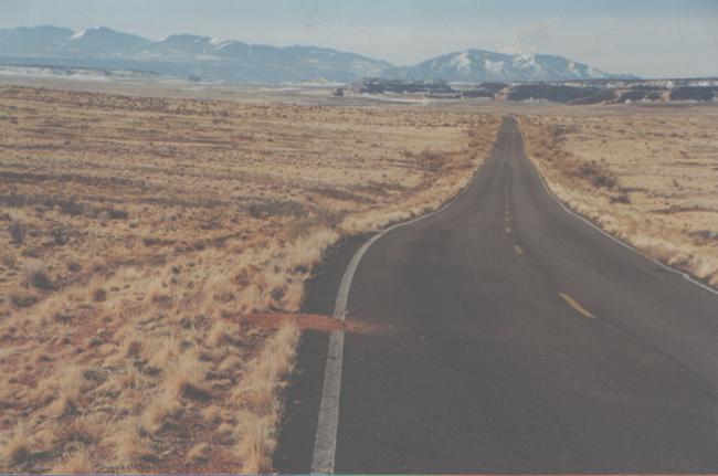
The Road To/From Nowhere
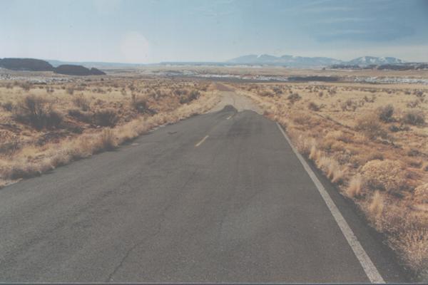 About
27 miles south of Moab on US 191, Wilson Arch towers above the highway, tourists
slam on their brakes in the middle of the road, and locals like me swear and
curse at them and wish it was\legal to travel with proton torpedoes mounted
to the front bumper.
About
27 miles south of Moab on US 191, Wilson Arch towers above the highway, tourists
slam on their brakes in the middle of the road, and locals like me swear and
curse at them and wish it was\legal to travel with proton torpedoes mounted
to the front bumper.
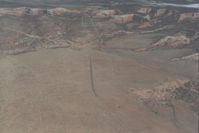
Just before the arch, however, as you travel south, the old right-of-way veers to the southwest. The road, out of use for more than 40 years is returning to Nature. The asphalt is crumbling, the rabbitbrush grows along the fades centerline, the edges of the highway are breaking off and disintegrating.
But for .6 mile, the highway is inexplicably paved, complete
with fog and center lines. Then, as suddenly as it began, the pavement end
and the old highway reappears. An aerial view shows the new pavement clearly.We're
bewildered. The highway that starts nowhere, goes nowhere, and ends nowhere.
If only ALL roads were like this...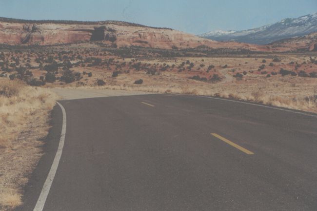
The Canyonlands National Park Pinyon/Juniper Graveyard
Before the early 1980s, when the road to Grandview Point was still a narrow
dirt track, the trip was dusty and slow. One of the reasons the trip took
so long was because it was rocky and rutted and you couldn't go very fast
without rattling all your teeth loose.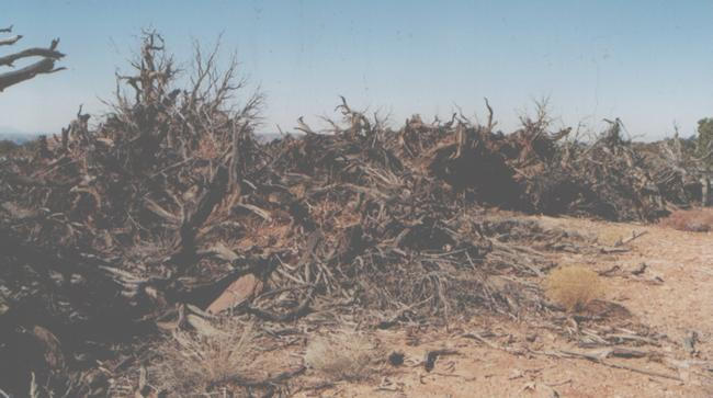
Another reason why it took so long is because the road went around trees and followed the topography of the terrain instead of going through it (and them).
Of course, when the NPS finally and reluctantly paved the road, it took out most of the curves and leveled the dips and humps.
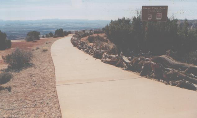 As for
all the juniper and pinyons that the new highway went through, they ended
up at the end of a service road near the Green River Overlook. The Tree Graveyard
used to be much larger; in fact, it covered several acres. Now, in fact, the
NPS is using the same trees it killed as protective fences at overlooks to
regulate pedestrian traffic! So over the last two decades, the pile has been
reduced somewhat, but the graveyard still speaks volumes about modern highways
and the ease of travel in the 21st Century.
As for
all the juniper and pinyons that the new highway went through, they ended
up at the end of a service road near the Green River Overlook. The Tree Graveyard
used to be much larger; in fact, it covered several acres. Now, in fact, the
NPS is using the same trees it killed as protective fences at overlooks to
regulate pedestrian traffic! So over the last two decades, the pile has been
reduced somewhat, but the graveyard still speaks volumes about modern highways
and the ease of travel in the 21st Century.
AND THE #1 SECRET PLACE OF CANYON COUNTRY:
THE WHITE MESA MILL at BLANDING, UTAH!
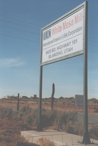 Southeast
Utah has been doing the backstroke in nuclear waste for half a century and
the White Mesa Mill has been an integral part of that legacy. When it opened
in the 1970s, the mill processed "home-grown" uranium from mines
in the Four Corners area. But the domestic uranium industry went belly up
in the early 1980s when the price of the ore plummeted. Energy Fuels, the
mill owner, struggled to stay afloat and eventually sold out to the International
Uranium Corporation (IUC). With no profitable ore to dig up and process, Energy
Fuels and then IUC sought license amendments from the Nuclear Regulatory Commission
(NRC) to accept "alternate feed materials." So in the last five
years, according to the Utah Department of Environmental Quality, the mill
has sought to "receive, process, and dispose of over 1,000,000 cubic
yards of waste," from just one site in St. Louis alone. It has also received
waste products from sites across the country; even by-products from the original
Manhattan Project, the world's first controlled nuclear reaction, have found
a home at the White Mesa mill.
Southeast
Utah has been doing the backstroke in nuclear waste for half a century and
the White Mesa Mill has been an integral part of that legacy. When it opened
in the 1970s, the mill processed "home-grown" uranium from mines
in the Four Corners area. But the domestic uranium industry went belly up
in the early 1980s when the price of the ore plummeted. Energy Fuels, the
mill owner, struggled to stay afloat and eventually sold out to the International
Uranium Corporation (IUC). With no profitable ore to dig up and process, Energy
Fuels and then IUC sought license amendments from the Nuclear Regulatory Commission
(NRC) to accept "alternate feed materials." So in the last five
years, according to the Utah Department of Environmental Quality, the mill
has sought to "receive, process, and dispose of over 1,000,000 cubic
yards of waste," from just one site in St. Louis alone. It has also received
waste products from sites across the country; even by-products from the original
Manhattan Project, the world's first controlled nuclear reaction, have found
a home at the White Mesa mill.
Now, the mill wants 840,000 tons of contaminated dirt from Maywood, New Jersey. According to the Sierra Club, the dirt contains radioactive thorium, volatile organic compounds, pesticides, metals, and other hazardous wastes." The dirt would be hauled by rail to Cisco, Utah, and then by truck through Moab, Monticello, and Blanding at a rate of 46 to 86 loads per week, for seven years!
And if that's not enough good news, IUC could not pass up
the opportunity to get its hands on Moab's own Atlas Tailings Pile. Most advocates
of re-locating the multi-million ton pile have proposed that they be moved
20 miles north to a location on Klondike Flats, near I-70. But IUC wants to
build a slurry line, almost 90 miles south to the White Mesa mill.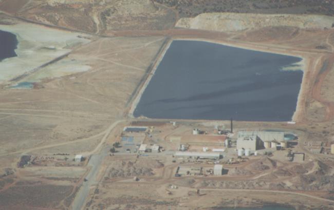
These guys just love nuclear waste.
And yet, while other nuclear waste sites get all kinds of publicity, the White Mesa Mill struggles along in relative obscurity. Until recently, the only press it was able to muster came from The Zephyr's Ken Sleight, who has been shining all the light he could upon it for years. But now the Sierra Club has entered the fray and hopes to give the mill a lot more attention in the near future.
So...to our pals at IUC we award them "The Zephyr's #1 Secret Place." CONGRATULATIONS! You may be reinvigorating SE Utah's old moniker as "Uranium Capital of the World," but we'd bet the second home market in Blanding is awful...especially when the wind blows.