Tag: Lake Powell

The Irony of Glen Canyon Dam’s Eventual Demise —Jim Stiles (ZX#98)

If you didn’t live through the 1950s, there’s a commonly held but false impression that ‘nothing happened’ during the decade… But the decade of the ‘50s initiated the groundwork, literally, for what was to come. After a decade of the Great Depression and four years of world war. Growth was inevitable, but the explosive growth was stunning…

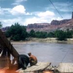
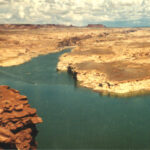
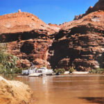
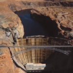
In order for the arid Southwest to grow far beyond anything that could be called “sustainable,” proponents needed two rare commodities for the arid deserts — water and power. Projects like Glen Canyon Dam and the Powell Reservoir were planned and built with that goal in mind.

Damn sustainability…full speed AHEAD.

OVERLAND to FORT MOKI in GLEN CANYON —With a Sad Update by Tom McCourt (ZX#91)

By the end of 2004 the water level in Lake Powell had dropped more than a hundred feet. Seven years of drought had greatly reduced water flow into the lake. At the same time, an ever-increasing demand for irrigation and municipal water was sucking the lake dry. Utah, Arizona, California and Nevada all had straws in the water. Competition over who could get the most was intense.

But, for some of us, the fading fortunes of the lake were not all dark and gloomy. The dramatic drop in water level presented a possibility that intrigued some of us. If the water was that low, what had happened to the old Indian fort at the mouth of White Canyon? Was it possible that Old Fort Moki would be coming out of the water again?

WHITE CANYON…The Drowned Little Town Beneath Lake Powell …Tom McCourt (ZX#81)

My last trip to White Canyon was in December 1959. It was just a few days after my thirteenth birthday. Grandpa was going to the desert again to do assessment work on his uranium claims, and he asked if Reed and I would like to go along. I was thrilled. I had been given a little box camera for my birthday, and I was excited by the opportunity to take some pictures before Lake Powell covered my favorite place forever.

Before we even started, I had a feeling about that trip; a premonition I suppose. Somehow I knew that this would be my last visit to that special place of my childhood. I was going to White Canyon to say goodbye….

DOWN the ESCALANTE RIVER w/Ken Sleight —By Edna Fridley (ZX#63)

FROM KEN SLEIGHT,
“Edna soon came to Escalante and met many of the town folk. Coming and going from trips, we spent a lot of time at cousin Mohr Christensen’s Moqui Motel. My clients met there and at the other rustic-looking motels in Escalante when coming on trips.

“Edna loved Escalante Canyon and became intimately familiar with its features. We frequented Coyote Gulch more than any other canyon. It contains Jacob Hamblin and Coyote natural bridges and Jug Handle Arch. At its mouth and across the river, Stevens Arch looms high on the skyline. Negotiating this country often came hard. Going down Coyote Gulch on one trip, a giant part of the wall broke away and crashed into the creek bottom below, forming a natural dam. My old intrepid friend Vaughn Short, who helped me a lot through those years, aided me in fashioning a detour around the slide and I got our horses and mules around the long pool of water. Edna followed that trail on numerous occasions, as it led to Indian wall writings.”

A GLEN CANYON ALBUM: THE NIELSEN RANCH at HITE (1949-1964) #2 (ZX#56)

In the first installment of this series, called “Glen Canyon’s Nielsen Ranch at Hite: The Untold Story,” I provided a considerable amount of background information on the history of the Hite (Dandy) Crossing, and the political history behind the building of Glen Canyon Dam.

In addition, I needed to explain just how Beth and Ruben Nielsen wound up at Hite and spent the next 15 years, from 1949 to 1964, in this place they called Heaven on Earth. (I urge all of you who missed Part 1 the first time, to go back and read it. You need the history, especially of Beth and Ruben, to fully appreciate what follows.

In this edition of the “Untold Story” is more of an album than a narrative. This is the first of several albums I plan to post over the coming weeks and months. When Leslie sent me a thumb drive with the complete collection of images, even I didn’t realize the full extent and number of photographs that I had just received. The index that Leslie sent me identifies each photo—the index is almost 50 pages long! That should give Zephyr readers just how much photographic history is here. It is a treasure beyond my ability to express it

E.C. LaRue & the Colorado “River of Menace & Destruction” (ZX#33) By Gene Stevenson

“The river of menace and destruction”… In the early 20th century, that’s the way farmers in the Imperial Valley of California viewed the Colorado River after it breached its banks and flooded into the Salton Sink in 1905-07. This wasn’t the first time the mighty river had jumped its banks, but the agriculture industry was determined this HAD to be the last. And it was – maybe. I’m not going to rehash how the Colorado River Compact of 1922 came to be passed by a bunch of politicians who gathered together in some isolated resort lodge near Santa Fe, New Mexico. But one key player is seldom mentioned when the history of the grossly inaccurate Compact is discussed. Or the devastating effect it poses on the future of the Colorado River Basin. His name was Eugene Clyde LaRue.

Even though erroneous assumptions were made and compiled in various tables, E.C. LaRue knew the Colorado River better than almost anyone, and was the most experienced engineer, even if his goals for the river were as wrongheaded as everyone else. He had personally surveyed just about every tributary and segments of main stems of the entire Colorado River Drainage Basin. Why did his compatriots give him a place at the table? Who was this guy anyway?

GLEN CANYON & HITE OVERLOOK—The View for the Past 51 Years w/Jim Stiles (ZX#30)

But in the late 1960s, plans were made to pave the entire Hanksville to Blanding Road. In addition they would have to find an alternative for the ferry. The waters of Lake Powell reached Hite by 1964. The ferry was gone. To replace this simple operation would not be easy. At pool level the lake would be too wide for a single bridge. And so UDOT devised a plan to connect the two sides of the river by constructing three new bridges. It was their only option. Coming from the east, the first formidable barrier was White Canyon. It was a narrow crossing but very, very deep. Once that obstacle was overcome, the new road descended toward the Colorado. At the point where Narrow Canyon meets the Glen, the largest of the three bridges crossed the Colorado River. Finally there was the Dirty Devil River to get over. Thus bridge number three.

When I first discovered the old Utah Hwy 95 in 1971, I was coming from the east and Blanding. The road stayed paved for just a few miles before it turned to dirt. I reached the top of the Comb Ridge Dugway, descended 2000 feet to the wash and then climbed out of the wooded verdant valley and onto Cedar Mesa

It was like another world, I saw no one…. and then everything changed.

THE HITE FERRY in GLEN CANYON w/ Edna Fridley & Charles Kreischer (1959-1962) ZX#21

CHARLES KREISCHER & EDNA FRIDLEY loved the West, and especially the Colorado Plateau. Both explored the canyons of southeast Utah in the days when very few people even knew they existed. At the time, most Americans’ knowledge of the Colorado Plateau came from John Ford movies, and they rarely mentioned film locations in the credits. But Charlie and Edna knew, and they took hundreds of amazing Kodachrome transparencies to remember their experience

In a previous issue The Zephyr published images by Kreischer and Fridley of the road to Hite Ferry— old Utah Highway 95 — which remained a dirt and gravel road from Blanding to Hanksville, until the rising waters of Lake Powell flooded the ferry. Subsequently, three bridges were built, at a cost of millions of dollars, to connect the east side of the reservoir to the west.

In this issue we focus entirely on the Hite Ferry itself and the surrounding area. And at the end of this post, look for some new information and of new images yet to come…JS

UT Hwy 95: The Road To Glen Canyon & Hite Ferry w/ Edna Fridley & Charles Kreischer: 1959-62 (ZX#16)

In this selection of Kodachrome transparencies by Edna Fridley and Charlie Kreischer, I assembled the images as if one were traveling from Hanksville to the Hite Ferry, and then eastward through White Canyon, and past the Bears Ears on the way to Blanding. The entire journey was about 135 miles. These photos were taken by both photographers and at different times, between 1959 and 1962. I’ve done my best to assemble them in order, based solely on my recollection of the landscape after driving Utah 95 hundreds of times over the past 51 years…JS

REMEMBERING PHILIP HYDE: Revered Photographer & an Honorable Man—by Jim Stiles (ZX#11)

Two epiphanies would come from that moment. On the back jacket, I read both biographies and realized that Abbey had written the 1956 novel “Brave Cowboy,” upon which the 1962 film, “Lonely are the Brave” was based. I had seen that movie on television, a decade earlier, and it had a profound effect on me and on my future. To this day, it’s one of my favorites. The bios also included photos of both men. I studied them closely and decided to learn more about Mr. Hyde as well.

Eleven years later, when I started The Zephyr, I knew exactly where I had stored Phil’s calling card, so I signed up Phil Hyde as a complimentary Lifetime subscriber. A few months later, to my surprise, I received a card from Phil. He still remembered our encounter from 1978 and wrote to thank me for the complimentary subscription and to wish me well in my endeavors. Over the years, he became a Zephyr supporter and contributed a few letters to the Feedback page.