Tag: San Juan County

OVERLAND to FORT MOKI in GLEN CANYON —With a Sad Update by Tom McCourt (ZX#91)

By the end of 2004 the water level in Lake Powell had dropped more than a hundred feet. Seven years of drought had greatly reduced water flow into the lake. At the same time, an ever-increasing demand for irrigation and municipal water was sucking the lake dry. Utah, Arizona, California and Nevada all had straws in the water. Competition over who could get the most was intense.

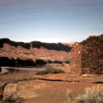
But, for some of us, the fading fortunes of the lake were not all dark and gloomy. The dramatic drop in water level presented a possibility that intrigued some of us. If the water was that low, what had happened to the old Indian fort at the mouth of White Canyon? Was it possible that Old Fort Moki would be coming out of the water again?

“THE HOME OF TRUTH” —– By Lloyd Pierson (For Marie Ogden’s Followers in the 1930s, the Vortex of the Universe was at Photograph Gap) ZX#24

Visitors to the Needles District of Canyonlands National Park may wonder what the three groups of rag-tag buildings are along the entrance road shortly after leaving the Moab to Monticello Highway. The rapidly deteriorating buildings give little indication of the dreams and high holy aspirations of their former inhabitants. It was on this desolate sagebrush plain that a religious colony (some called it a cult) was founded. Its not so modest name? “The Home of Truth.”

Well, Truth theoretically has to exist somewhere and this forlorn spot in the great Colorado Plateau is probably as good a place as any for the elusive deity to reside.

The colony was founded by Mrs. Marie Ogden in 1933, a well educated widow from New Jersey, after she received a spiritual revelation. Mrs. Ogden’s husband, an insurance executive, had died in 1929 at an early age, back in New Jersey. In her grief she turned to serious religious study and, guided by an inner light, began to seek “the truth” and an understanding of life and death. As she delved further into religion she began to preach and to convince others of the correctness of her beliefs. Her religious activities took her over most of the east preaching and lecturing and at least as far west as Boise, Idaho, where she reportedly had the revelation to establish a religious colony devoted to “the truth”.

RANGER JIM CONKLIN: Copter Crash Hero/Scapegoat (ZX#17)… by Jim Stiles

Jim Conklin was furloughed for the winter and the two of us took some road trips together. We helped move our friend Dave Evans, a ranger buddy at Bridges, to his new job at Carlsbad Caverns and there was plenty of time to talk. The topic of the chopper flights weighed heavily on Jim and he often spoke of the possibility that a faulty aircraft, a helicopter he knew was dangerous, might kill him.

He came back on duty in late February, but quickly learned that nothing had changed. The helicopter surveillance flights would continue. And often, the BLM would still use the Hiller 12Es. The first scheduled flight was Monday, March 14, 1976.

Just a few days earlier, Conklin and I had driven over to the west side of Horseshoe Canyon, via the old Green River road with its amazing ancient wooden bridge over the San Rafael River. I had never seen the Great Gallery before, though Jim had been there several times. Jim decided not to tell me when we were getting close; he wanted me to have that singular moment when I looked up and gazed upon this most extraordinary work of art for the first time. I think Jim was as thrilled by my reaction–the surprise of it–as he was to return and see the pictographs again. That was Conklin. We lingered into the early afternoon, then made the steep hike up the West Trail and the long drive home. He reminded me that he started work in just a few days and hoped he’d live long enough to visit Horseshoe Canyon again. He was that worried and that preoccupied with the risks.

POKING THROUGH the RUINS: KUTA-AM RADIO in BLANDING, UTAH (ZX#15)…by Jim Stiles

But the AM station I relied most heavily on, and the station I still miss, was KUTA in Blanding, Utah, “1450 on your AM dial.” It sat atop “Radio Hill,” about five miles north of town and just off the old highway. When the Recapture Dam was completed and US 191 was re-routed to go over the top of it, the traffic outside KUTA ground to a halt, but the little station kept broadcasting from its cinder block headquarters . It was probably one of the most scenic locations for a radio station that ever existed. And until the Millennium it was probably the only station that a traveler or a resident could pick up during the day. Once the sun set, the more powerful “clear channel” stations, those boasting 50,000 watts of power, would start to override the small AMs and completely dominate the airways. We all knew them by heart and where to turn on the dial.

But until the sun went down, it was pretty quiet out there. If you were in need of the sound of a human voice, there were few options. I have discovered for myself that I love solitude and peace and being away from noise and human chaos, as long as it’s optional. If I know I can return to friendly faces and people who care about me, if I know that my solitude is limited to the amount of time that I enjoy it, then it’s perfect. But when total aloneness is the only choice left to me, that’s when, for me, being alone feels more like ‘lonely.’

Naming “Government Rapid” on the San Juan River: How Everyone Got It Wrong …by Gene M. Stevenson

RBMV foldboat crew lining Piute Rapid

Government Rapid on the San Juan River isn’t just misnamed, it’s in the wrong place! The name is based on a supposed boat accident that occurred during the 1921 USGS Trimble Survey of the river. We know it is located somewhere downstream of the Goosenecks portion of the river canyons and upstream of Slickhorn Canyon, but where exactly remained a question in 1956 when Otis “Dock” Marston asked Kenny Ross – “where exactly is Government Rapid?”