
The Lake Powell Disaster Congressional Commission was authorized by Congress on November 15, 1992 to investigate the causes and effects of the Lake Powell disaster of July 4, 1992. Approximately 200,000 investigative man-hours have been expended, involving twenty-three different government agencies, thirteen independent contractors, and testimony from over 500 witnesses and experts. It is the opinion of the commission that all currently available data relevant to the event has been recorded. This is a summary of the investigation. All material collected, in formal reports and raw data, is in the custody of the Library of Congress. The Commission members wish to thank all those who have worked on this massive undertaking, with special thanks to the individual members of Congress who have been instrumental in providing avenues for collection of information and testimony. This report is dedicated to the estimated 1300 people who lost their lives in the disaster.
Background
Glen Canyon is located in northern Arizona and southern Utah. At its southern end the canyon is  approximately 700 feet deep and 1400 feet wide. It terminates at Lees Ferry, Arizona, where it abruptly exits the Navajo Sandstone geologic formation into a relatively level area. Through the years, numerous dam site suggestions near the end of Glen Canyon have been made; the first was by Major Powell during his historic 1871 voyage down the length of the Colorado River.
After decades of study and negotiation, Congress authorized the Glen Canyon dam in 1957. Sited approximately four and one half miles below the Utah/Arizona border and sixteen river miles upstream from Lees Ferry, it was completed in 1964. The original constructed height was approximately 710 feet, with a width across the top of the dam of 1560 feet. The closest town is Page, Arizona, two miles east, which was created to support the dam. In 1963 the gates of Glen Canyon Dam were closed, restricting flow on the Colorado River to begin forming Lake Powell. In subsequent years the lake filled, creating a reservoir of twenty-seven million acre-feet by 1980. Lake Powell represented one of the major water control features of the Colorado River Storage Project. Turbine generators at Glen Canyon Dam created four billion kilowatt-hours of electricity annually.
Over one million visitors used the lake as a major recreational facility as recently as 1991. On July 4, 1992 a partial collapse of the upper part of the dam released more than one third of the water in the reservoir in a little over three hours. The resultant flood was unprecedented in historic times and is classed as the worst peacetime disaster ever recorded. It took over 1300 lives and caused approximately twenty-eight billion dollars worth of damage to capital facilities downstream. Irrigation, flood control, electric power generation and recreational facilities for all western states were affected permanently.
The Trigger Event
This description is reconstructed from witness reports and is believed to represent the most probable sequence of events. The actual facts, if different, would not be sufficiently different to be of consequence.
The vicinity of Lake Powell experiences occasional violent thunderstorms and flash flooding in mid summer. Thunderstorms during the three or four days preceding the disaster were exceptionally frequent and violent, probably a result of the extra moisture from the previous winter, which was unusually wet and resulted in filling Lake Powell to its historic high level of 3708.4 feet. It is almost certain that the sandstone formations bordering Lake Powell had been saturated with this unusual amount of moisture and therefore weakened. The afternoon of July 4, 1992 experienced continuous thunderstorms and associated heavy downpours.
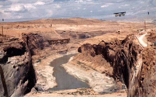
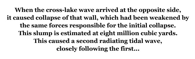
At approximately 4:32 of the afternoon of July 4, 1992 a massive piece of the western sandstone perimeter of Lake Powell, weakened by subsurface immersion during the twenty-four year life of the lake, the immediately previous wet winters, the continuous rain during the preceding days, and immediate flash flooding, collapsed into the lake. The displaced volume of material has been estimated to be 17.6 million cubic yards. This created a “tidal wave” radiating upstream, across the lake, and downstream from the collapse point. The upstream wave caused no major damage. The lake width was about 0.5 miles at this point.
When the cross-lake wave arrived at the opposite side, it caused collapse of that wall, which had been weakened by the same forces responsible for the initial collapse. This slump is estimated at eight million cubic yards. This caused a second radiating tidal wave, closely following the first.
Effects of the Event
Effect on Glen Canyon Dam
Glen Canyon Dam is 7.4 miles downstream from the wall collapse point. It took approximately ten minutes for the downstream wave from the initial collapse to reach the dam. Due to the depth of the lake bottom at this point the behavior of the two leading waves from the two collapses was similar to deep water ocean tidal waves. A tidal wave in deep water causes a small, placid, vertical displacement of the water surface. When the wave reaches shallow water, the shore water is sucked outward, followed by inundation as the wave crest reaches the shore. After inundation, the water returns to normal level. The depth of Lake Powell simulates ocean geometry. The dam, however, presents a vertical boundary, exactly the opposite of the sloping boundary of an ocean shore.
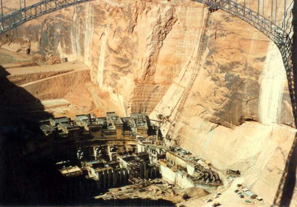
Simulating ocean mechanics, the first wave caused a drawdown against the upstream side of the dam. The drawdown depth is unknown. This was followed by inundation, which undoubtedly spilled over the dam. Unlike shallow, sloping shores in ocean conditions, the near-vertical wall of the dam would cause a series of drawdown/inundation cycles at the dam. The first inundation was therefore followed by another drawdown. The second wave, caused by the collapse of the east wall, arrived approximately coincident with the second inundation of the first wave. The effect of the combination was an even larger breach of the dam. The top section of the dam was destroyed, releasing a massive wall of water and dam debris, a flood vastly larger than any known to recorded history. Actual drawdown depths and breach volumes cannot be determined with any precision. The effects, however, are known. After the waters had calmed, between ten and eighty feet of the top of the dam had been torn loose and carried downstream. The turbine bays and machine shop below the dam were washed away. The highway bridge immediately below the dam remained intact but was battered by debris. One single concrete boulder weighing eighteen tons with rough measurements of eight by four by five feet was deposited on the bridge roadway. Approximately eleven million acre-feet of water were released during the three hours immediately following the event. This brought the lake to the 3619-foot level, the lowest point of the break in the dam.
Upstream Effects – Lake Powell
The lake level lowered approximately eighty feet in three hours, the majority of the elevation change and water discharge taking place in the first thirty minutes.
Approximately 200 boats, mostly rented houseboats, containing over 700 people, were swept over the dam in the rush of water. A much larger number were stranded on newly formed shore or remained floating on the lowered lake. Since the current during the initial drainage varied from extremely fast near the dam to mild 200 miles upstream, survival depended on distance from the dam and proximity to shore. Those some distance from the dam were able to motor upstream faster than the current caused by the draining. Those near shallow, sloping shores were able to ground themselves as the water receded. Boats moored at shallow slopes were quickly beached. Boats moored to vertical walls broke their mooring lines as the water level fell. Most occupants were able to scramble to safety in the few minutes available as the water level rapidly dropped.
The most tragic were those near the dam who could not reach shore or motor against the current and were swept into the flood almost immediately.
Approximately one half the floating facilities at the Wahweap marina were lost. Six people were lost; all others on the floating marina facilities, warned by the initial wave swell travelling toward the dam from the slump, had sufficient time to get to shore. Due to their distance from the dam, Dangling Rope Marina (forty miles upstream), and other facilities further from the dam saw no loss of life.
Downstream Effects – Marble Canyon
The narrow gorge of Glen Canyon continues sixteen river miles below the site of the dam, ending abruptly at Lees Ferry and the Paria River. This gorge continues the typical convoluted, twisted path of original river bed above the dam site.
Average depth is 600 feet, average width is 1,000 feet. During the first moments of the flood, this almost square channel carried the full flow of the breached dam, plus the debris from the dam and rock dislodged from the canyon walls. At each river bend, rock and concrete pieces carried by the flood made gouge marks, some of them 350 feet above the channel bottom. Debris deposits and water marks indicate that the straight sections of the channel were half filled during the flow. At abrupt changes in channel direction, the water overflowed the canyon, spilling onto the surface of the plateau into which the canyon cuts. Unnatural rock and concrete debris fields on the canyon rim are remaining evidence. An estimated seventeen boats with an estimated sixty-five people were in this section, upstream of Lees Ferry. All are assumed to have perished in the flood.
Other than detail surface changes in the walls of this section of the canyon, there was no major damage. There was no permanent human habitation in the canyon, and no improvements. Other than the loss of life mentioned above damage was therefore minimal. Debris from the dam and from some partially collapsed canyon walls have created several new rapids in this section of the river.
Downstream Effects – Lees Ferry
The site of Lees Ferry was sixteen river miles downstream from the dam, where the river channel exits Glen Canyon. John D. Lee, an early Mormon settler and pioneer said to have been fleeing federal prosecution, originally settled this remote site. In the past twenty-five years, Lees Ferry had become the launching point for numerous raft trips through the Grand Canyon. Mid summer was the most 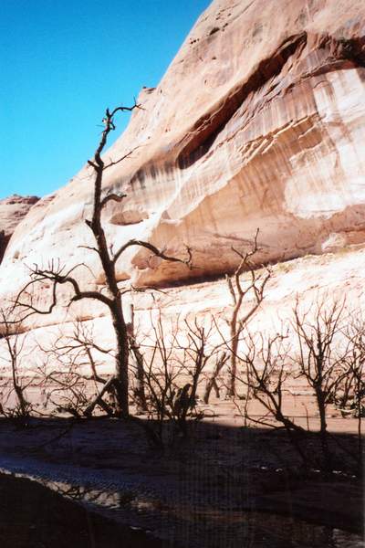 popular time for such expeditions, and Lees Ferry was filled with commercial rafters and their clients at the time of the disaster. Lees Ferry was completely destroyed; no evidence of it remains. Water marks, mud flats, and dam debris cover an area averaging 1.5 miles from the river channel center and some distance upstream along the Paria, a tributary at Lees Ferry. Most of the large pieces broken loose from the dam were found near the site of Lees Ferry, where the canyon walls did not restrict the flood. Several large pieces of concrete (fifty feet high) were deposited approximately O.5 miles up the Paria river channel. Remains of two of the dam’s electrical generators now rest just downstream of the end of Glen Canyon, just above Lees Ferry. Magnetometer readings have located two more buried in silt approximately 0.2 miles downstream. Debris identified as coming from Lees Ferry has been found in the Gulf of California near Cabo San Lucas. Due to its proximity to the dam, Lees Ferry received minimal warning of the flood. Casualty estimates for the Lees Ferry site are twenty-seven permanent residents and 320 temporarily at Lees Ferry associated with rafting. The only survivor was a lone hiker who was on the western bluff above the town near Dominguez Pass. Substantial loss of life occurred at Jackass Wash, approximately eight miles below Lees Ferry. This is a short, narrow tributary of the Colorado, cutting through the normally precipitous wall containing the river. In the years before the disaster, it had become a popular access route for fishermen, drawn to the trout living in the clear, cold water below the dam. Approximately seventy-five people were at this site; all but eight were swept away by the flood.
Downstream Effect, Grand Canyon
The first helicopter in the air after the breach was operated by the National Park Service and was prepared for a survey of boating on the lake. The pilot realized the danger to river rafters and was airborne approximately ten minutes after the event. Within the next two hours approximately twenty others joined her helicopter, all flying the canyon announcing warnings. Undoubtedly these pilots and crews saved many lives due to the early warning. Of the approximately 650 rafters on the total length of the river at the time of the flood, approximately sixty are confirmed casualties while seventy are missing and presumed lost. Most of the casualties were close to Lees Ferry and did not have time to get to high ground before the flood arrived. That no one who was caught by the flood survived attests to the massive flow. The only permanent habitation between Lees Ferry and Lake Mead, approximately eighty-eight river miles downstream from Lees Ferry, is Phantom Ranch, at river level in the middle of Grand Canyon National Park. The facilities of Phantom Ranch are between 200 and 1000 yards from the river, at elevations from twenty to two hundred feet above the river. The ranch had telephone service, and therefore received notice about ten hours in advance of the flood. Most residents escaped to higher elevation on the Clear Creek trail immediately behind the ranch. Casualties were limited to four people. Some livestock, corralled near the river channel, and all livestock facilities were lost.
Downstream Effects, Below Grand Canyon
Lake Mead, formed by Boulder (Hoover) Dam, lies 275 river miles below the Glen Canyon damsite. Operators of Boulder Dam had approximately thirty hours warning before the flood arrived. During that time, they released water at the maximum rate. When the flood reached Lake Mead the leading crest had subsided to about two feet in height. No sudden wave reached the dam. The flood filled the lake, swamped the spillways and, approximately forty-eight hours after the event, spilled over the full width of the dam. The overspill lasted approximately twenty-six hours and eroded a foot of concrete from the top of the dam. At no time was Hoover Dam in danger of failure. Flooding below lake Mead was classed as severe, although it was mitigated by the volume absorbed by Lake Mead, its damping (plenum) effect, and the leveling effect on the crest caused by the distance from Glen Canyon. There was no visible crest of the flood below Lake Mead. Flooding in the Needles, California area was approximately double the flooding that was seen in the previous record high flows of 1984. Out-of-channel depths were approximately twice those of 1984, and approximately twice as much area was inundated, One earthen dam in the Lower Colorado was destroyed. The desalting plant below the Mexican border was not damaged.
Warning was adequate and at the request of the Gobernador of the Mexican state of Baja California Norte the U.S. Army Corp of Engineers built an earthen dam around the facility. Erosion of the river banks in the channel close to the outlet at the Gulf of California caused closure and ultimate collapse of the single-lane combination road and rail bridge there.
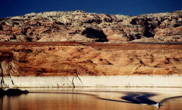
Subsequent Condition Of Lake Powell
Approximately eleven million acre-feet (450 billion cubic feet) of water were released during the three hours following the breaching of the dam. This brought the lake to the 3619-foot level, the elevation of the lowest point of the breach in the dam. The Bureau of Reclamation, which had responsibility for the dam, realized that it would be some time before the detail causes of the disaster were determined. To minimize the possibility of a recurrence, it immediately ordered further reductions in the level of Lake Powell. Continuous releases through outlets just below the 3400-foot level lowered the lake surface to 3500 feet as of April, 1994. It is anticipated that this release rate will continue until engineering and political solutions are attained. At the current rate, Lake Powell will be effectively drained, returning the Colorado River to free flowing, by January 1995.
An Analysis of the Causes
Sandstone Porosity
The walls forming Glen Canyon are almost entirely sandstone. Due to the relatively large granularity of sandstone, it is more porous than shale and limestone rock structures. During the twenty-four years prior to the event the walls of Lake Powell were exposed to water from the lake resulting in water absorption and migration into the walls. Tests since the event have been conducted to determine the amount of water absorption. The tests show that absorption increases dramatically with the pressure of the water against the sandstone surface. At depths of 400 feet, the approximate depth of Lake Powell at the event site, water absorption rates are approximately 100 times greater than at the surface of the lake. Prior to the event no absorption studies were performed, and there were no attempts during the life of the lake to inspect the condition of the underwater canyon walls. Since the low water absorption at the surface was balanced by evaporation in the semi-desert environment, there was no noticeable weakening of the visible rock. It is estimated that over ten million acre feet of water were absorbed by the sandstone perimeter of the lake during its lifetime.
Sandstone Strength and Mechanical Integrity
The extensive sandstone water absorption tests were accompanied by tests of compression strength of sandstone at various moisture levels. A near linear relation between water content and strength was observed. At maximum saturation, the minute layers of bonding material formed over long time periods and high pressures weaken and can no longer hold the sandstone together. When this occurs, the sandstone loses all strength. One critic of the damsite before its failure compared submerged sandstone to slowly dissolving sugar cubes. The commission has discovered several independent sources of evidence of sandstone weakening under high moisture conditions. None were studied during design of the dam and behavior predictions of the subsequent lake, though all were available at the time. It is instructive to review them.
Canyon Alcoves
Throughout the Colorado Plateau, the parent geography of Glen Canyon, numerous sharp canyons have been cut by erosion into the underlying sandstone formations. The walls of these canyons are often vertical, from several hundred to a thousand feet high. Surface drainage courses that have not cut as deeply as the canyon form waterfalls where they intersect the deep canyons. These flow only during flash storms, or with rare extended storms. During the rest of the time continuous water seepage along the drainage occurs, which has the effect of keeping the surface of the vertical wall at the waterfall continuously wet. Over long periods the saturated surface sandstone loses strength entirely and gradually falls to the floor of the canyon as grains of sand, to be carried away by the flash floods. The erosion of the walls is faster near the bottom of the wall, where temperatures are cooler and lower evaporation keeps the sandstone saturation level higher. Water absorption in this situation is much slower than took place at Lake Powell due to the lack of water pressure. Over geologic time, however, the effect is to form erosional alcoves under the intersections of the surface drainage courses with the canyons. This mechanism has been known for some time and reported in numerous geologic periodicals. It was ignored in the design of Lake Powell.
The Sphinx
Slow erosion of the shoulders of the Sphinx at Giza in Egypt has been reported for over 150 years. Tests in the 1950s showed that the rate of erosion had accelerated in recent years. The cause of the erosion is the recent growth of Cairo, which brought the edges of the city to within several hundred yards. This in turn raised the humidity of the area, and raised the water table due to leakage from the city’s water supply and sewage system. This increased moisture changed the balance of water absorption and evaporation at the site of the Sphinx. The approximate three percent increase in the moisture content of the rock forming the Sphinx, a rock similar to the sandstone forming the walls of Glen Canyon, has caused unintended erosion of the vertical and overhanging portions. The phenomenon was extensively studied and reported in the 1950’s. The mechanism was not used for analysis of the integrity and stability of Lake Powell’s walls.
Slickrock Formations
Returning to the Colorado Plateau, a study of slickrock formations is instructive. Where sandstone is exposed to surface elements, it erodes. The sharper surfaces erode more rapidly, causing a general smoothing effect. After long periods of exposure, the result is large, pillow-shaped formations with relatively smooth surfaces. “Slickrock” is the descriptive term applied to these. The mechanism of slickrock formation has been studied. Almost all erosion occurs when the sandstone is wet, due to rain or melting snow. Moisture penetration is low since the surface is wet for very short periods. Each wetting cycle is only enough to penetrate a small distance into the geologically formed cement holding the surface grain of the sandstone. The water saturation is enough to weaken the cement. If the saturation occurs during a rain shower, the force of raindrops is enough to carry away small cement particles. If the mechanical force of the rain does not remove the cement, it dries after a period of time, leaving a weakened cement that can be carried away by wind or the next rain. Eventually enough of the cement holding a sandstone particle is removed to free the particle, which exposes the next particle beneath to the same process. This mechanism is the same that occurred to the walls of Glen Canyon, although on vastly different scales of time and dimension. The process had been known as much as seventy years before the dam was constructed. The knowledge was not used to estimate the effect of immersion of the walls of Glen Canyon.
High Water Level
Lake Powell was almost at full capacity at the time of the disaster. High Colorado River flow rates had been experienced due to the preceding abnormally wet year. Meteorological long-range forecasting predicted an end to this wet cycle. It had therefore been decided to retain water rather than discharge it rapidly, and gradually reduce the water level as the drier part of the year progressed. This decision was primarily due to two factors. There was heavy political pressure from victims of the 1984 downstream flood, who did not want the experience repeated and were willing to accept the long-range forecast. Additionally, there was mounting ecological concern for erosion of beaches in the canyons downstream of Glen Canyon. Excessively high flows in previous years had substantially reduced the total beach area and had changed the ecological balance in the canyons. Additionally, commercial river-runner’s concern about adequate camping spots, almost always beaches, for their tours, was a third but less-important factor in the decision.
Conclusion
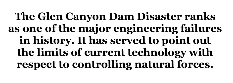
The Glen Canyon Dam Disaster ranks as one of the major engineering failures in history. It has served to point out the limits of current technology with respect to controlling natural forces. In the few short years since the event it has had profound effects on almost every proposed and in-progress environmentally sensitive project. Emergency reviews of all water storage projects have been undertaken, with the result that over ten percent of previously flooded rivers have been returned to their natural state, with the prospect that an additional fifteen percent will be returned in the next two years. The effect on other countries has been similar, though not as pronounced. One cannot escape the conclusion that nearly everyone in the country has been affected, and that our attitude toward modification of natural features has been changed. Nature has taught us a lesson, a hard one, which should not be repeated.
Copyright 1990, Thomas S. Budlong
TOM BUDLONG developed guidance systems for the aerospace industry and later made desktop and early hand-held calculators, word processors and graphics software. Now an environmental activist and a lifetime member of the Desert Protective Council, he scrutinizes impacts from off-highway vehicles, mining and alternative energy projects. Tom spends as much time lost in the backcountry as possible.
To read the PDF version of this article, click here.
To comment, scroll to the bottom of the page.
Don’t forget the Zephyr ads! All links are hot!


Went up the river in a Grumman canoe with my family in 1963 at age 6. I’ll never forget it. Had to cut the trip from two weeks to one as the beaches flooded. I still wish the dam would go away in my life. My parents gave me I gift I can’t pass on to my own children.
Scott: Jan. 10, 2016
Wouldn’t you know it, I was at Lake Powell, with my family on July 4 1992. Oddly enough, the level of Lake Powell was the same on July 5, and 6, and 7 as it was on July 4. I suspect that most of “Thomas S. Budlong’s” work is fiction, as was this one.