
Four months ago, the Grand County Council presented a proposal to build an “energy transportation corridor” via Sego Canyon, through the Book Cliffs, to possible oil development sites in the northern tip of Grand County. The plan included the creation of a paved highway, for energy transportation and tourism, that would have linked Vernal, Utah with I-70 and other recreation destinations in southeast Utah. It also proposed a corridor for energy pipelines.
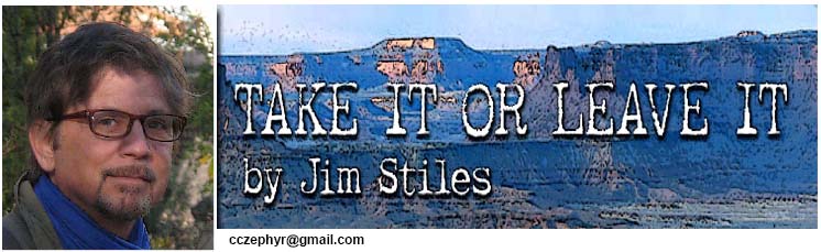
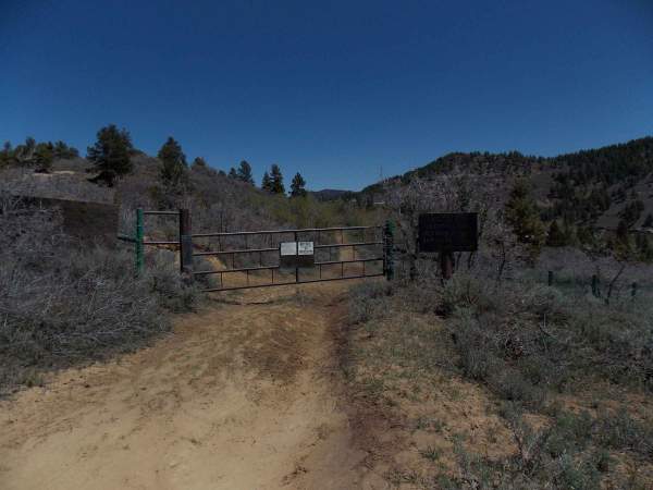
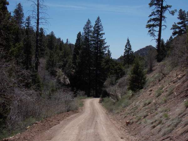 Sego Canyon is narrow, isolated, and undeveloped, accessible only by an unimproved dirt road. It ends at the Ute Indian reservation boundary. A gate was constructed by the Utes in the mid-80s and the completion of the proposed transportation corridor would require the construction of at least ten miles of new road, through some of the most rugged terrain in the American West.
I drove the Sego Canyon road twice this summer and it was obvious that the construction of the kind of paved highway and pipeline right-of-way a project like this requires would be devastating. I cannot overstate how much destruction would occur if this project went forward. It would require the removal of every plant and tree, from one edge of the canyon floor to the other, for 20 miles, to accommodate the scale of the proposal.
Last month, Grand County Council Chair Lynn Jackson, who helped spearhead the Sego Canyon plan, suggested that the feasibility studies being performed for Grand and Uintah Counties broaden their focus. He wants to include another north-south route through the Book Cliffs—the Hay Canyon route. This was the same corridor promoted in the early 90s, which was vigorously opposed by many Grand County citizens.
Read more in “16 Questions for Grand County Council Chair Lynn Jackson, on the Book Cliffs Highway.”
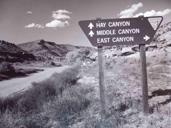
 The proposal then was to “construct an 83 mile-long roadway to Utah Department of Transportation (UDOT) and Federal highway standards…A 200 foot ROW (Right-of-Way) would be required along the entire route.” The highway would have mostly followed existing dirt roads and jeep tracks, but the terrain would have been dramatically altered by the expanded highway. The Proposed Route would have descended the Book Cliffs via Hay Canyon to its confluence with East and Middle Canyons, then south to I-70.
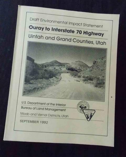 The BLM rejected the plan; its “agency preferred alternative” was called “Paving Existing Alignments Alternative.” It called for paving part or all of the existing roads, but an expanded ROW was rejected. Any paving would be required to stay within the current rights-of-way and the idea of a tourist highway, built to UDOT and federal standards, between Vernal and Moab was rejected.The BLM considered “Environmental Consequences” of the proposed route in Section 4 of its EIS. They were many and I include just some of them here…
“Areas of the proposed route underlain by the Douglas Creek Member of the Green River Formation are considered to have a potential for landsliding if large volumes of material are excavated and filled to form road grades.”4.2.5.1 Terrestrial Wildlife
“Adverse impacts to big game following completion of the highway would include increased traffic and human use resulting in disturbance and displacement…increased hunting pressure and harvest; increased poaching mortality; and increased mortality from vehicle-animal collisions.“Following construction, the proposed highway would increase disturbance in the bald eagle wintering areas..there is also the potential for bald eagle mortality die to increased motor vehicle collisions.
“Mule Deer mortality from motor vehicle collisions can be significant where highways cross important deer ranges…The Proposed Route bisects key big game ranges and migration routes.”
4.2.6.3 Threatened, Endangered, or Other Sensitive Plant Species
“Nine federally-listed candidate plant species would potentially be affected by construction along the Propose Route.”
4.2.1 Wilderness
“The Proposed Route could not be approved or constructed under the BLM’s Wilderness Management Guidelines because the quality of wilderness values in both WSAs would be reduced.”
4.2.14.1 Cultural Resources
“Adverse impacts to significant cultural resources may occur as result of several project-related activities.”
4.2.19 Irreversible/Irretrievable Commitment of Resources
“Construction of the proposed highway would involve the commitment of a range of natural, physical, human and fiscal resources that could result in the irreversible or irretrievable commitment of these resources. Irreversible is a term that describes the loss of future options. It applies primarily to the effects of use of nonrenewable resources such as cultural or paleontological resources, or to those factors, such as soil productivity, that are renewable only over long periods of time. Irretrievable is a term applied to the loss of production, harvest, or use of natural resources…The disturbance of cultural and paleontological resources would be an irreversible and irretrievable loss.
These references reflect just a portion of the EIS. So today, as Grand and Uintah Counties (hopefully) move away from the Sego Canyon option, they must still consider that their alternative, Hay Canyon, at the scale they are proposing, was examined and studied more than two decades ago, at a cost of hundreds of thousands of dollars, and the conclusion in 1992 was that the proposal was untenable.
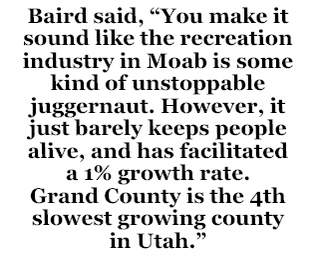
I realize that the intention of the Grand County Council is to find new ways to generate revenues for its citizens. As the population of Grand County expands, so will demands for services. Tourism and the amenities economy will not generate the kinds of revenues required to satisfy its citizens’ needs, especially as their demand for services keeps growing. Even former Councilman Chris Baird (now running again), agrees that tourism can’t generate the kind of revenues needed to sustain its population. In a long email conversation with Baird in August 2012 about tourism, he said, “You make it sound like the recreation industry in Moab is some kind of unstoppable juggernaut. However, it just barely keeps people alive, and has facilitated a 1% growth rate. Grand County is the 4th slowest growing county in Utah.”
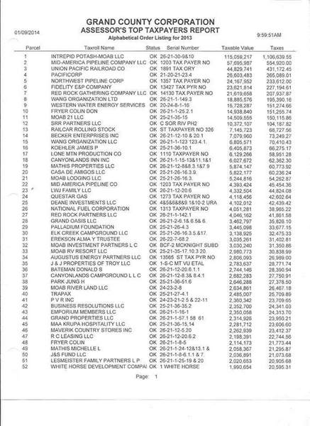
 With that kind of understanding, even from one of its most aggressively anti-energy politicians, Grand County must either submit to more energy development, just to pay its ever-expanding bills, or learn to live with less. Grand County’s budget last year topped $12 million. In 2013, seven of the top ten taxpayers were tied to energy or the transportation of energy. Their combined contribution to the tax base exceeded $2.7 million—almost a fourth of total tax revenues. If environmentalists and progressives in Grand County want to oppose energy development in their home county, they should consider ways to downsize their expectations for the community. For years, I’ve talked about the issue of “production vs consumption.” I cannot offer a better example than the conflicted and sometimes hypocritical values you see here.


These conflicts will continue and folks need to stay aware of issues like this on a local level. Recently in central Kentucky there was a big blow about a pipe line being built. (Another one). This one would have been major though and effect land on a large scale. In the end, for the most part no locals were for it and for now the issue is dead in the water. Rail lines are dangerous enough. The existing gas lines are dangerous enough. Each issue like this needs to continue to be closely examined. Folks don’t always realized what is being transported on trains until one has an accident and blows away a section of town or contaminates it. Bad business. Too bad that trains can’t be required to only transport beer. I doubt that would be an issue.
I’ve recently scrutinized the Sego Canyon haul route and have some observations to add:
1. The area that the Grand Co. Council is targeting for a 2 mile wide corridor, cut out of wilderness study areas, is totally unnecessary. There is no reason to move the road out of the canyon bottom and up onto the cliffs. The Council is attempting to take 30 square miles of wilderness off the table for no good reason. The Sego Canyon road is a B road which means that it is maintained, and recently so.
2. The road-less area above Sego Canyon was created when the Ute tribe closed the road atop Went Ridge. They only own about 1.5 miles of the road. But, due to a feature immediately to the east of the gate called “Hell’s Hole”, you can’t go around the Ute land. To the north, the Ridge Divide road comes with 2 miles of the old Went Ridge road. However, between the two is E. Willow Creek.
3. In order to get from Steer Ridge (Ridge Divide Rd.), across E. Willow Creek, and back up to Went Ridge would require a 1,400′ descent at a 26.8% avg. grade and then another 1,400′ ascent up Went Ridge at a 36.8% avg. grade in about 1.5 miles. This 1.5 miles is the only part of the proposed haul route that hasn’t already been constructed as some kind of road. To put this canyon crossing in perspective it is useful to compare it to other more commonly encountered extreme roads. One would be the drop into Mineral Bottom leading into the White Rim and Canyonlands National Park. The Mineral Bottom road drops a little less than 1,000′ feet and has an avg. grade of 20.1%. So both sides of the E. Willow Creek crossing would be both higher and steeper than the Mineral Bottom Rd. And, because it is a canyon crossing as opposed to an escarpment drop it entails a major ascent and descent as opposed to a singular ascent or descent (depending on your direction of travel.)
4. The first question really shouldn’t be how much it will cost, but, even if it gets built, could it ever serve as a major thoroughfare for industrial traffic? The obvious answer is NO. It would be far too slow and treacherous.
5. At this point I think the Sego Canyon proposal is being used as a “fake bargaining chip” in the Bishop Public Lands Initiative process. As in, at some point they will drop the proposal, but try to maintain the threat so as to use it in the “horse trading” of wilderness etc. I think it is a bluff that can easily be called.
6. And, of course, the above is in addition to the obvious environmental destruction that would come as a result of Anadarko’s oil/gas exploits in the road-less area. I’ve recently spent a lot of time backpacking the road-less area to better understand its value. It is simply off-the-charts amazing and is known the world over as one of the best big game hunting areas in the western United States. It really is incomparable backcountry territory with large populations of elk, deer, bear, bison, cougar, greater sage grouse, Colorado River Cutthroat Trout, etc. It is somewhat heart breaking getting to know this place at the precipice of its demise.
Hay Canyon is certainly a less environmentally destructive route, however it doesn’t avoid the larger regional and even global implications of facilitating tar sands and oil shale strip mining. Bitumen mining wasn’t a threat during the first go round with the “Book Cliffs Highway” proposal. In my opinion the environmental threat has grown by an exponential level. It is true that any economy these days relies on oil/gas to one degree or another, but strip mining tens and ultimately hundreds of thousands of acres for tar sands and oil shale far exceeds a reasonable impact for anyone’s lifestyle. The land impact from the oil/gas operations around Big Flat and Spring Canyon are going to be less than 1,000 acres. The ultimate impact from oil shale and tar sands, in full swing, will be in the hundreds of thousands of acres. There really is no comparison between the two. And due to the fact that bitumen crude production and refinement produce substantially more CO2 than conventional petroleum production we are taking about a global climate impact.
Troubling times.
Chris Baird
One addition, if permissible, links (Facebook) to photos of the roadless area of the Book Cliffs, Grand Co., Utah.
https://www.facebook.com/media/set/?set=a.680573541998588.1073741829.218512514871362&type=1
&
https://www.facebook.com/media/set/?set=a.676302049092404.1073741828.218512514871362&type=1
Chris, thank you for your detailed comments and links. I’m on the upper (Duchesne) side of the dispute, and I can’t easily get down to the good stuff that you in Grand co. can access easily. I have the reservation in the way.
I’m happy to hear neither option being batted around will be successful. I’ve always been a fan of improving Dragon via Baxter Pass, cutting west towards I-70 once you’re down from the cliffs.