
The bridge is gone, the station is gone. The people are gone, and what is left is concrete, asphalt, concrete and sameness!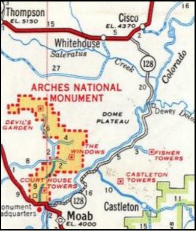
Not much is left of Dewey, Utah is along the Colorado River near the Dewey Bridge. Originally named Kingsferry, it began in the 1880s after Samuel King built and operated a ferry across the Grand River and a small community soon developed around the ferry. (3) The town served as a ferry crossing until the Dewey Bridge was constructed in 1916.
Actually there are two versions of the name source. The first and most preferred states that Dewey Smith, a prospector, camped by the river ford around 1880 where the Utah highway 128 crosses the river. The other version suggests that the name was taken from a raft used to ferry supplies and equipment down river to the mouth of Professor Creek on a raft named for Admiral Dewey.
The ferry was owned by Samuel King and operated by Dick Eastwood. In 1909 a one-year contract was awarded to George Coombs to operate the ferry for $20/month plus tolls. Gay Brown was the next ferryman. Brown also helped build the bridge at Dewey which was completed in 1916. In 1914 the ferryboat broke loose and floated 15 miles down the river. Apparently the ferry was not replaced before the bridge was finished.
Crude rafts and home built boats were common on the river below Cisco. In the early days (1879-1905) people living in Castle Valley went to the railroad in Cisco for supplies. The supplies were floated downstream by raft from Dewey to the mouth of Professor Creek, where the town of Richardson was located. Richardson had a post office, opened in 1886 and by 1905 the town had faded. In August 1898, Henry Grimm went 22 miles upstream from Moab in a 24′ row boat carrying about 500 pounds of supplies. He returned with 6,000 feet of lumber! Johnson, Iverson, Warner and Livingston boated from Dewey Bridge to Moab on August 1901. Walter Mendenhall, of San Juan River fame, floated from Cisco to Moab in a 14-15′ scow in fall of 1907.
 The Dewey Bridge, constructed in 1916, is on the National Register of Historic Places. It was designed to support the weight of 6 horses, 3 wagons, and 9000 pounds of freight. The bridge is (was?) significant for its outstanding engineering accomplishment and for its historical role as a vital transportation link connecting southeastern Utah with Colorado and points east.
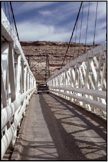
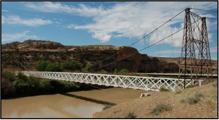
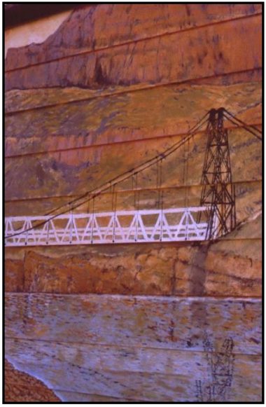
In the early decades of the Twentieth Century, Moab and other southeastern Utah towns were dependent on communities in western Colorado both for everyday supplies and for markets for their agricultural products. The bridge, which spans the Colorado River, was the first to provide a direct connection to those supplies. Dewey Bridge was Utah’s longest suspension bridge and, at the time of its construction, was the second longest suspension bridge west of the Mississippi. It is also the state’s longest clear span bridge. The bridge was originally brought in pieces built by the Midland Bridge Company of Kansas City, Missouri by rail and assembled across the Colorado River, 30 miles
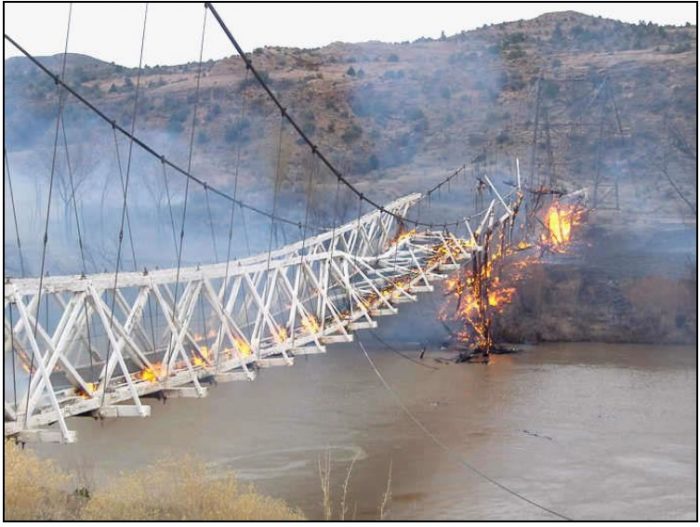
upstream from Moab, Utah. The bridge featured an all wood deck measuring 502 feet long, 10.2 feet wide from support to support and 8 feet wide from rail to rail. The bridge also consisted of two metal towers, a run of seven cables on each side of the bridge deck, and cable anchors. The old Dewey Bridge was burned on April 2008 by a 7-year-old playing with matches.
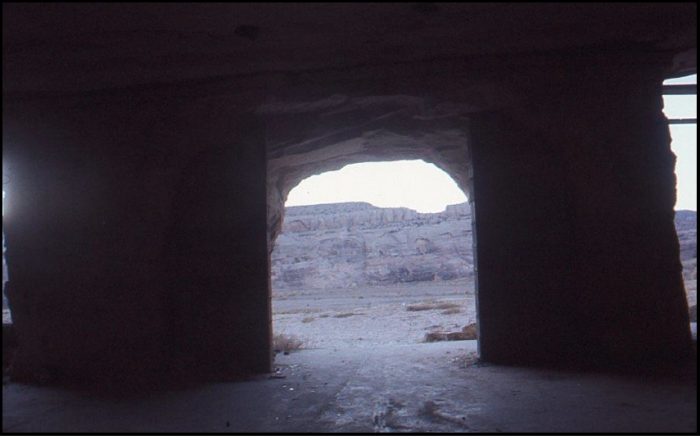
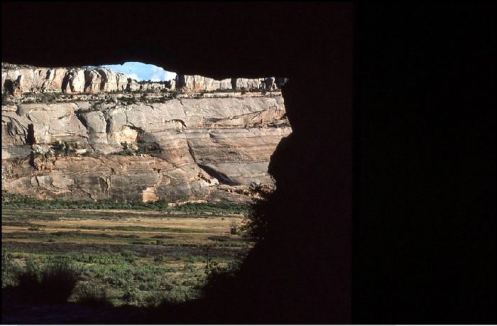
Access between Moab and Castle Valley was originally via a pack trail called the Heavenly Stairway. This trail, named for a dramatic descent of over 1,000 feet was described as beautiful, but difficult to navigate. Isolated from Utah’s population centers, this area depended on Grand Junction and other cities in Colorado for supplies and a market for agricultural products. Moab residents pushed for a road to be built along the riverbank. By 1902, the trail was replaced with a toll road, called King’s Toll Road, after Samuel King. King was the operator of the toll ferry used prior to the construction of the Dewey Bridge. Rocks inscribed with “Kings Toll Road” can still be found along the roadway. While the road improved travel, it was not built high enough above the river level and was often flooded.
By the 1920s the toll road was reconstructed above the ordinary high-water mark so it could be used year-round. The road was briefly used for the route of the Midland Trail across eastern Utah. However, by 1923 the trail had been moved to a more direct routing, similar to modern I-70. The road from Moab along the river to Castleton was added to the state highway network in 1931, as SR-129. In 1933, the route was redesignated SR-128 and extended to Cisco.
The highway was gradually upgraded to a two-lane paved roadway. By 1974, much of the gravel and dirt road from Cisco to Moab was paved, although the asphalt was rough and pitted, and the “improvements” were negligible. Even better, because Dewey Bridge was only one lane wide — barely eight feet — large vehicles could not get across it. Today, the highway is used as a scenic drive for visitors to the area.
The state legislature extended SR-128 about 3 miles at its east end in 1969, due to the pending construction of Interstate 70. Plans called for the freeway to bypass the Cisco area, including the terminus of SR-128. The legislature transferred a portion of SR-4 (the legislative designation for what was then signed US-6/US-50) near Cisco to the proposed interchange with I-70.
In 1985 the Utah Department of Transportation began construction on a new bridge, just down river from the old one, and when it opened, traffic on Highway 128 increased dramatically. Further “improvements” have brought still more cars and motorhomes and trucks. Sometimes it is downright congested. It’s a beautiful drive and those discovering it for the first time will be awestruck, but they’ll never be able to understand just what it felt like on that summer night in 1973.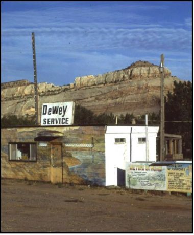
A few years ago, Jennifer Speers, the millionaire with a soul, bought up the adjacent Dewey Bridge subdivision from a developer. She plowed under the roads, dismantled the infrastructure and tore down a $600,000 home in order to restore the area to the way it had been.
Ballard and Maxine Harris lived at Dewey and set up the billboards, they were very nice people. (1.) Harris had a number of vocations during his lifetime, beginning as a cowboy in his youth, he worked for the railroad during WWII and then as a highway foreman for the Utah Department of Transportation for nearly 30 years, retiring in 1976. He also served as a field observer for the National Weather Service for 48 years and a field collector for the National Geological Survey for 38 years, every morning you could find Ballard in his orange UDOT jumpsuit on Dewey Bridge taking measurements to determine the river volume.
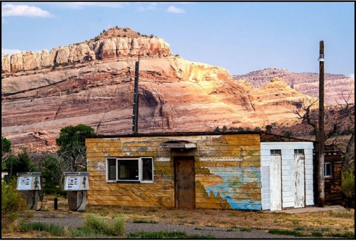
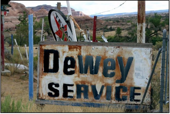
 Following his retirement, Ballard operated a service station along highway 128 near his home at the Dewey Bridge for many years, meeting and greeting tourists from around the country and the world and becoming somewhat of a tourist attraction himself in the process. In addition to establishing a store for gasoline, cold drinks and highly entertaining conversation for people in the midst of the desert, Mr. Harris devoted himself to providing a safe and reliable feeding station for hundreds of wild birds; peacocks, turkeys, doves, pigeons and many others, calling it his “offering” to God. A man of strong faith and conviction, Mr. Harris was a member of no organized church, but sought his Lord on a daily basis. Ballard Harris also ran the filling station at Cisco that supposedly was the inspiration for Johnny Cash’s song named Cisco Clifton’s Fillin Station.
Alvie and Susie Johnston, went to school in Cisco, and Alvie (a real character) told Paul LaFontaine that Maxine was the most sought-after girl in school. While working as a ranger at Westwater (’81, “84, and ’85) Paul always stopped at their place for gas. He spent a whole afternoon with them once, needing gas when the power was out, and had to wait for it to come back on so the pump would
work. Technology then advanced with satellite river volume transmissions and Maxine getting a TV satellite dish and the gas station thereafter was hardly ever open. Paul asked Maxine why and she told me that a John Wayne movie is always playing on the satellite TV at their house.
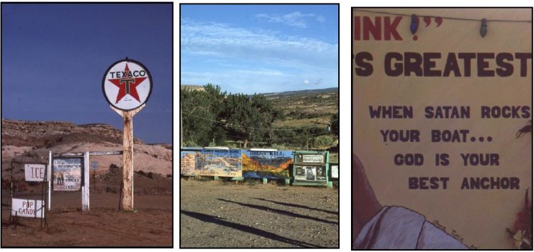
As time went on the property that was adorned with a variety of spiritual and social messages store and
signs became run down. The colorful array of signs including: The Ten Commandments; The Lord’s Bulletin Board listing the names and numbers for a mental health service, Alcoholics Anonymous, a number for runaway kids, and the Suicide Prevention Hotline; a sign listing all of the churches in the area; and a number of signs denouncing drug use. One of the many anti-drug signs said: “Warning! Drugs Do Kill. Say No.” There was a big sign proclaiming that “Three of the World’s Greatest Problems are (1) Misused Drugs, (2) Greed, (3) Waste” and “When Satan Rocks Your Boat, God is Your Best Anchor.”
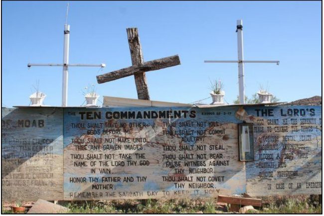
Harry Ballard Harris, 91, of Cisco, died Wednesday, Dec. 14, 2005 in Cedar City, he was born in Green River on June 28, 1914. There was a story that the religious signs were related to the death of a relative, but a search that rumor is not true. Harry just seemed to have through his ministry of kindness and hospitality to others, the intent to give others the messages on those signs.
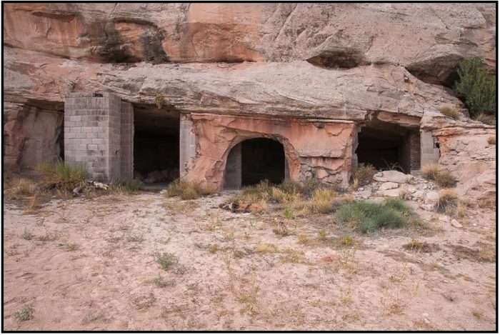
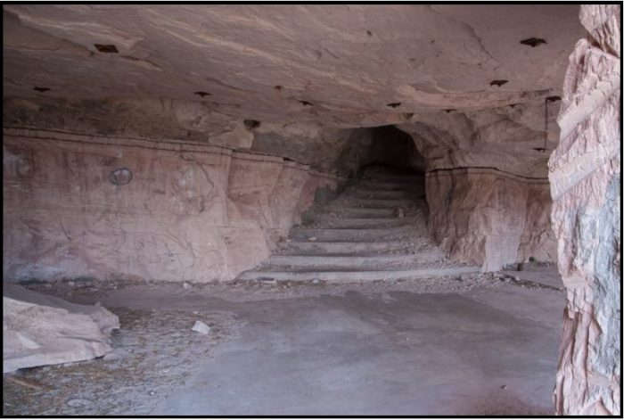
In 1976, not far from Dewey I found the remains of a partially completed rock house, with a beautiful, well-constructed grand staircase that led to a great view of the Colorado River And the river bottoms. Phil LaFontaine was told that one of the Moab Shumways was the builder, thinking it was on his land and not BLM. He was told otherwise and forced to leave it unfinished.

♦
(1.) Paul LaFontaine, retired BLM River Ranger (Westwater and Desolation/Gray)
(2.) Boating on the Upper Colorado – A History of Navigational Use Of The Green, Colorado, and San Juan
Rivers and their Major Tributaries; 1975; Crampton, Gregory, C. & Madsen, Steven K.; Department of
the Army.
(3.) Willis Thomas Lee, Ralph Walter Stone, Hoyt Stoddard Gale, Guidebook of the Western United States,
1916, p. 109
(4.) U.S. Geological Survey Geographic Names Information System: Dewey
(5.) Firmage, Richard A. (January 1996). A History of Grand County (PDF). Utah Centennial County History
Series. Salt Lake City, Utah: Utah State Historical Society. pp. 137–138. ISBN 0-913738-03-4.
Retrieved July 15, 2012.
(6.) Daughters of Utah Pioneers (1972). Grand Memories. pp. 127, 144. OCLC 4790603.
(7.) “Markers and Monuments: Dewey Bridge”. Utah History Resource Center. State of Utah.
(8.) “Midland Trail Will Come down River by Way of Moab, Legislature Decides”. Grand Valley Times.
Moab, Utah. April 19, 1919
(9.) “Paving Must Come in 1923; Work on Details is Pushed,”. The News-Advocate. Price, Utah. February 1, 1923.
(10.) Utah State Legislature (1931). Chapter 55: Designation of State Roads. Session Laws of Utah. (129) From Moab along south bank of Colorado river to Castleton.
(11.) Utah State Legislature (1933). Chapter 30. Session Laws of Utah. (128) From Moab along south bank of Colorado river to Cisco.
{All Photos by Herm Hoops – Except Dewey Bridge Fire Photo}
To comment, scroll to the bottom of the page.
Don’t forget the Zephyr ads! All links are hot!


Let me start by saying, I greatly enjoyed your article. I was trying to find information of when they restricted vehicle use on the Dewey Bridge (if at all), as I seem to have memory of my parents taking the slightly “longer way,” so that we could go over Dewey. Your writing at least gave me a time frame for further research, so thank you!
I was intrigued by the last portion of your article however. Where, approximately, is this staircase that was built by the Moab Shumways? I’ve never heard of it, and I haven’t been able to find any further information on it on the internet. I would be interested in photographing it myself if it’s still accessible.
Let me know when possible, thank you!
My great grandmother died 2 months after giving birth to my grandmother (January 21, 1901) and is buried in Dewey somewhere. Is there a cemetery in existence? any records? Would enjoy hearing from you.
There are two graves as you start down Robert Bottom. There could be others there, but two names are noted. Henry Wearing, died 1918 and a L. Blockhart. Area has a beautiful view.
The housing development adjacent to the Dewey Bridge was called Rio Colorado. I took a nice color brochure when the lots went up for sale.
I wonder if the Dick Eastwood in the beginning of the article could have actually been Richard (Dick) Westwood? I have a photo of the plaque that is at the Dewey bridge. I tried to attach it but was unable.
I have a envelope which is called a “postal cover” and the postmark on it is Richardson, Utah. It is dated November 14, 1894. It is probably the rarest one that i own!! I would love to find or see a ” Dewey or Kingferry, Utah postmark but the post office at Dewey was only there from 1898–1902 and in june 1902 they renamed the Dewey post office to Kingferry after the King brothers and in August 1902 the post office was closed permanently.
I was travelling back to Colorado from a climbing trip in Utah that fateful day and saw the bridge burning, a truly sad sight.