
This article first appeared in the Utah Historical Quarterly, and is reprinted with the permission of the author.
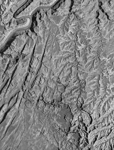
Canyonlands National Park, established in 1964, is the largest national park in Utah and was the first new national park formed in the continental United States after World War II. Viewed at the time of its creation as “the Nation’s last opportunity to establish a national park of the Yellowstone National Park class—a vast area of scenic wonders and recreational opportunities unduplicated elsewhere on the American Continent or in the world,” Canyonlands today is vastly different from Yellowstone in terms of visitor amenities. (Footnote 1) Its Needles District, for instance, has few paved roads and no lodges and concessions. In particular, the Chesler Park/Grabens region at the heart of the Needles is remote and accessible only to hikers and people with four-wheel-drive vehicles.
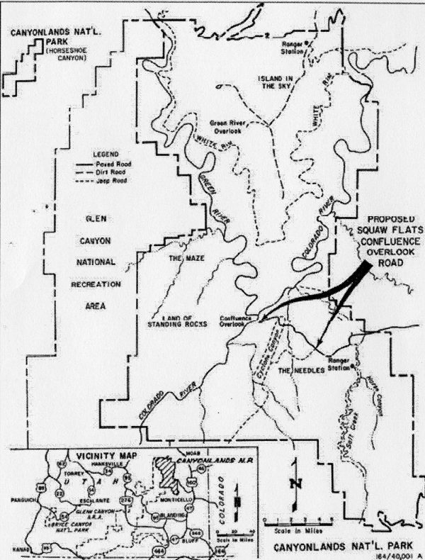
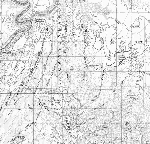
The contrast between the road accessibility envisioned at Canyonlands’ conception and the eventual lack of development of the park is evident in a comparison of the Canyonlands Master Plan of 1965 with the General Management Plan (GMP) of 1978 (still enforced today). The Master Plan of 1965 proposed five paved roads. The present-day road terminating at Big Spring Canyon (‘A’ on map on page 332) was to leap the canyon in a graceful bridge, and continue to a juncture. From there, a one-mile paved road would lead to a stunning view overlooking the Green/Colorado River confluence (‘B’). South from the juncture, the road would make its way deep into the Grabens area, running through Devils Lane.
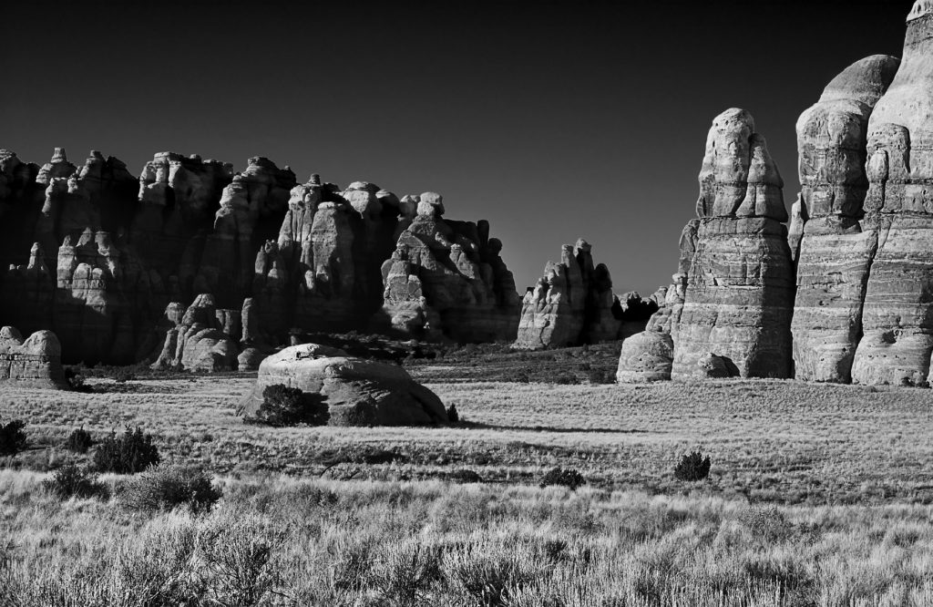
A mile or so outside of Chesler Park (‘C’), a spur road would climb into Chesler Park, the centerpiece of the Needles District. As a congressional report noted, “the placid parks, particularly Chesler and Virginia, ringed by the bristling forest of fantastic [rock] needles, are outstanding.”(Footnote 2) Once in Chesler Park, a paved road would take visitors around the inner circumference of the park to waiting picnic tables and a view of the impressive Devils Pinnacles and the five-hundred-foot-tall, mile-long central reef of layered white and pink Cedar Mesa sandstone. The main road, outside of Chesler Park, would run south through Beef Basin and its archeological jewels along the east flank of the Abajos to State Route 95, just east of Natural Bridges National Monument between Blanding and Hanksville, Utah. This latter road would be called the Kigalia Parkway (‘D’).
The rationale for these five roads was clear. The nation’s citizens could have access to Chesler Park, and once there, as San Juan County officials insisted, they must have the option of taking the Kigalia Highway loop road, which would enable them to visit and spend money in Monticello and Blanding. However, the GMP of 1978 rejected all of these access roads, simply stating that, “The road [to the] . . . Confluence Overlook [which was key to the Chesler Park road and the Kigalia Highway] will not be completed as previously planned because of excessive construction cost and irreversible environmental damage.”(Footnote 3)
The transformation of Canyonlands’ Needles District from the proposed accessible recreation area to a preserved wilderness-like area resulted from the convergence of two events. First, the exorbitant costs of the Vietnam War caused at least a ten-year delay in constructing the access roads into the Needles District. Second, when monies became available for road construction, new superintendents of Canyonlands and their superiors in the National Park Service favored a more aggressive preservation of the natural areas of the park.
A core quandary of Canyonlands’ development was eloquently summarized in 1972 by Thomas F. Flynn, acting director of the Park Service: “If the average visitor is denied this [access] he may well ask what is the point in having a park at all.” (Footnote 4) This question was inherent within the divided purpose of the Organic Act of 1916, which established the National Park system to both “conserve the scenery” so that it be “unimpaired for the enjoyment of future generations” and “to provide for the enjoyment” of the current generation. (Footnote 5)
Only in 1978 did the nation finally resolve this conundrum with the amendment to the Redwoods National Park Act. This act clarified the Organic Act: “authorized activities . . . shall not be exercised in derogation of the values and purposes for which these various areas have been established.” The courts have repeatedly interpreted this amendment to mean that for the Park Service “resource protection [is] the overarching concern,” that its “primary management function with respect to wildlife is preservation,” and that its purpose is “to leave [its units] unimpaired; this mission had and has precedence over providing means of access, if those means impair the resources, however much access may add to the enjoyment of future generations.” (Footnote 6)
This preservation-focused interpretation of the Park Service mandate, however, was not dominant in the 1950s, or even in the mid- 1960s when Canyonlands was formed, even though the Wilderness Preservation Act had just been passed in 1964. The change over time in the Canyonlands roads encapsulates a national shift emphasizing preservation over tourist access.
Canyonlands was conceived in the 1950s, when “providing access” was the talisman of the Park Service, a focus strongly supported by a rapid increase in visitation following World War II and the deplorable state of the park infrastructure. Visitors to the parks encountered decrepit park roads, campgrounds, and lodges. According to Reader’s Digest in 1955, parks had poor sanitary conditions, with campgrounds “approaching rural slums.” (Footnote 7)
Connie Wirth, director of the National Park System, responded with the aggressive Mission 66 program, a ten-year proposal quickly approved by President Dwight D. Eisenhower and Congress to restore and revitalize the parks. Mission 66 sought to protect park resources and at the same time develop them for public use. Critics of Mission 66, however, felt that development was taking precedence, with too many roads and an “urbanized” feel. As the National Parks Magazine criticized, “‘engineering had[s] become more important than preservation,’ creating wide, modern roads similar to those found in state highway systems.” As was noted about Rocky Mountain National Park, “[i]ronically, Mission 66, by ‘modernizing’ the Park and by making travel in it more attractive and comfortable, had detracted from the Park’s scenic naturalness. . . . [Wide] roads ma[d]e Park travel easier but not necessarily more meaningful.”(Footnote 8) In respect to wilderness, the Park Service maintained that there are “different kinds of wilderness, including . . . accessible wilderness, available with a ten-minute walk from many park roads, or where visitors could ‘see, sense, and react to wilderness, often without leaving the roadside.’”(Footnote 9)
The effort to create Canyonlands involved those with varied interests: those most focused on boosting the economy of southeast Utah both through tourism and the unimpeded use of natural resources—minerals, oil, and grazing; those most focused on a large national park with road access; and those advocating on behalf of scenic preservation.
The local support for some type of Canyonlands park was in response to the series of southeast Utah boom and bust cycles since the late nineteenth century involving free-range cattle, dry farming, and uranium mining. (Footnote 10) At a hearing on the proposed park, one local said, “Monticello in 1955 was on a boom, jobs were plentiful . . . now, 7 years later, business is poor, jobs are scarce, vacant houses and apartments are numerous. In 1956 I had six men working for me in the plumbing and heating business but now I do not have enough work for myself and there is no other plumber here.” (Footnote 11)
Although many locals desired the creation of several smaller isolated parks (presenting “this image of wilderness, the image of protection”) and multiple-use of the other adjacent lands, Democratic Utah Senator Frank E. Moss (in conjunction with Bates Wilson, then superintendent of Arches National Park) walked the delicate and often tortuous line to ensure the creation of a large national park. Senator Moss felt that developing tourism through the creation of national parks would be a long-term and effective means of increasing the economies of southern Utah towns. (Footnote 12) Moss and his allies in southeast Utah were convinced that “Canyonlands would become the Yellowstone of southeast Utah.” (Footnote 13) As summarized by one San Juan County resident during the congressional hearings on the proposed national park, the locals would benefit greatly from roads and other developments as soon as possible to “build and grow the additional tourist business.” (Footnote 14)
Stewart Udall, Secretary of the Interior in 1962, fueled these hopes by saying, “we have proposed to spend millions of dollars developing this [Canyonlands] like we have developed Grand Canyon, Dinosaur, and all the national parks, . . . with construction of approach roads and judiciously located park roads within the area itself to make the inspirational values accessible for the people of our country.” (Footnote 15) At the birth of Canyonlands, therefore, people expected road access within the Needles District in the immediate future.
The 1965 Master Plan encoding the access roads in the Needles District was approved by Bates Wilson, the newly appointed superintendent of Canyonlands. Wilson, who had proselytized for Canyonlands protection prior to its formation, now had the duty to implement this plan. However, he had various conflicting interests to contend with. On the one hand, many opposed access roads that would exploit and despoil the land. On the other hand, vehicular access was paramount. As one Moabite and Park Service employee who had never hiked the Chesler Park/Grabens area observed: “Now the panic of fear sets in that man eventually might ruin Canyonlands National Park with modern intervention. Not so.” Those “who prefer to thrill at nature’s wonders in a less vigorous way will be able to drive their modern cars over smooth paved roads to the colorful fantasy land. Nor should the most ardent wilderness lover begrudge these access roads which will make the sights of Canyonlands available to all Americans. . . It’s too big and too tough to spoil.” (Footnote 16)
NEXT TIME: Conservation issues take center stage…
Clyde L. Denis is Professor of Biochemistry at the University of New Hampshire.
My thanks to Vicki Webster of Canyonlands National Park who facilitated my easy access to many of the documents cited in this article…
Footnotes:
(1) U.S. Congress, House of Representatives, An Act to provide for establishment of the Canyonlands National Park in the State of Utah, and for other purposes, 88th Cong., 2nd sess., August 17, 1964, 9.
(2) U.S. Congress, House, Canyonlands, 6.
(3) U.S. Department of the Interior, National Park Service, “Canyonlands General Management Plan,” October 1978, U.S. Department of the Interior.
(4) Thomas F. Flynn to Assistant Secretary for Fish and Wildlife and Parks, June 23, 1972, memorandum, fd. 286, CANY 36607, Canyonlands National Park Administrative Collection, Southeast Utah Group Archives, National Park Service, Moab, Utah (hereafter Canyonlands Collection).
(5) Lary M. Dilsaver, ed., America’s National Park System: The Critical Documents (Lanham, MD: Rowman and Littlefield, 1994), 392.
(6) U.S. National Park Service, Environmental Quality Division,
Canyonlands National Park and the Organic Act: Balancing Resource Protection and Visitor Use, by David A. Watts (U.S. Department of the Interior, 2008), 10–14
(7) Reader’s Digest warned prospective visitors to parks: “Your trip is likely to be fraught with discomfort, disappointment, even danger.” Conrad L. Wirth, Parks, Politics and the People (Norman: University of Oklahoma Press, 1980), 237.
(8) Lloyd K. Musselman, Rocky Mountain National Park Administrative History 1915–1965, (Washington, D.C.: Department of the Interior, National Park Service, 1971).
(9) Richard West Sellars, Preserving Nature in the National Parks (New Haven, CT: Yale University Press, 1997), 185–87.
(10) After the free range cattle industry died at the end of the nineteenth century, it was followed by the dry farming experiments of 1910 to 1930 in which San Juan County lost 35 percent of its farms. Clyde L. Denis, “Departure of the Late Nineteenth Century Cattle Companies from Southeastern Utah: A Reassessment,” Utah Historical Quarterly 80 (Fall 2012): 354–73; Clyde L. Denis, “Fallout from the Demise of the Large Cattle Companies of Late Nineteenth-Century Southeast Utah: The Economic Ascendency of Moab,” Journal of the West 53 (2014): 43–53. In the late 1950s, the southeast Utah economy plummeted when the Atomic Energy Commission decided that the military had sufficient uranium. From 1960 to 1970, Monticello lost 22 percent of its population, and by the mid-1960s Moab was viewed by non-locals as “a depressed region.” Katy Brown, phone interview with the author, May 2014.
(11) U.S. Congress, Senate, Subcommittee on Public Lands of the Committee on Interior and Insular Affairs, Proposed Canyonlands National Park in Utah: Hearing before the Subcommittee on Public Lands of the Committee on Interior and Insular Affairs, 87th Cong., 2d sess., March 29–30, 1962, 363.
(12) Ibid., 123; Michael Cornfield and Anne Zill, “Frank E. Moss, Democratic Senator of Utah,” in Ralph Nader Congress Project: Citizens Look at Congress (Grossman Publishers, 1972), 1–11.
(13) Glen Alexander, phone interviews with author, 2013– 2016.
(14) Testimony of James Black, President, Monticello Chamber of Commerce in U.S. Congress, Senate, Subcommittee on Public Lands, Proposed Canyonlands National Park in Utah: Hearing before the Subcommittee on Public Lands, April 25, 1963, 216.
(15) U.S. Congress, Senate, Subcommittee on Public Lands,
Proposed Canyonlands National Park in Utah: Hearing before the Subcommittee on Public Lands of the Committee on Interior and Insular Affairs, 52–58; Testimony of Max N. Edwards, Assistant Secretary of the Department of the Interior, in U.S. Congress, Senate, Subcommittee on Public Lands, Proposed Canyonlands National Park in Utah: Hearing before the Subcommittee on Public Lands, 38. The Department of Interior’s “Canyonlands” brochure of 1962 contains pictures of roads to the Confluence overlook and to and into Chesler Park.
(16) Maxene Newell, “It’s a Rugged Park,” Times- Independent (Moab, UT), May 19, 1966, 3.
To comment, scroll to the bottom of the page.
Zephyr Policy: REAL NAMES ONLY on Comments!
Don’t forget the Zephyr ads! All links are hot!
Ed Abbey’s “A Walk in the Park” in Abbey’s Road, though written from perhaps the opposite perspective, backs up this article’s understanding of the unique historical circumstances that led to the 1978 Canyonlands GMP. I think Utah was maybe a little behind the US as whole in reaching an economic peak in the 1970’s, and I think that peak explains why the local point of view lost to the more nationwide desire for a not particularly lucrative mode of tourism that the GMP favored. We’re well past that peak now and so I doubt we’ll see those values winning out in the future. The almighty dollar has returned as paramount in tourism planning.
Sometimes, more often than not, the essence of it all is lost without the people that were there… as in the case of CanyonlandsPark, ever hear of the Scourp and Summerville Cattle company? Land sold to BLM for 13…. million dollars to become the park in 1964, my wife’s grandmother was one of the 12 owners to the land that became the “PARK”>
Ray… My favorite account of the Scorup & Summerville Cattle Company comes from “One Man’s West” by David Lavender. Great book. I’d love to hear your story, if you’re interested…jim
Jim
Yes., happy to tell all I know, I am old and severely handicapped and terminally ill, it takes me a little while to get it done. I”ll go to work on it!
Ray
Nice historical piece; thank you for posting it. I’ve read Jen’s book re Bates (and bought many others for friends); that’s well done; and this piece has unique insight and background. I always imagine though that if society tried to pull this off today, it would never happen. Back then the UT Gov (Clyde) and US Senator (Bennett) were firmly against the park but others had more sway and it happened. I’ve hiked, backpacked, explored, traveled into (and then hiked and explored) for decades. This past fall visited Devils Kitchen with a former LE Ranger and three of us explored regions we’d not been in before and found rock art, old routes, cowboy art and other sundry features that are far off the beaten path. Evidence of cattle in the area still exists in some/many zones. I meet visitors “down there” every year, most have no historical reckoning or sense and some (with 4wd) merely “travel the backcountry routes” and rarely leave vehicles. The posts above re the old cattle company’s, interesting, but the details even before that, somehow lost in multi generational false memory, loss of memory or lack of recording re events of the past. History keepers though via book, magazine, internet (such as this) sustain (in part) the historical contours of canyon country.
I seem to recall seeing a map of SE Utah that included a planned road from Hanksville that would have cut through the heart of the Maze District with a large bridge over the Colorado near the confluence of the Green River…I believe it was from the ’50s and predated the creation of Canyonlands. I’ll be darned if I can find it now…have you ever heard of such a plan?
Joe, that map still existed in the 70’s when I worked at Canyonlands…in fact, the idea was gaining momentum again under the direction of “Unit Manager” Glen Alexander (see Denis’ footnote 13). Maybe he will cover this imbecilic plan in Part 2 or 3, I hope so!
[…] A plan to put an extended road network in Canyonlands National Park never came to fruition. The Vietnam War made funds scarce, and by the 1980s, the views changed. […]