
My favorite kind of road trip usually devolves into a series of decisions about what direction I’m going to take that day. I wake up and check the weather to see if there is anything I need to avoid. I find myself sitting on some gravel by the side of a road at a junction – the intersection of two highways – while I try to figure out which way to go. I may or may not have plans. There may or may not be an agenda, and my immediate plans may or may not play into the big picture. The big picture is often no more than “I have to meet my friend in Davis next Wednesday” or “I need to get my oil changed soon” or whatever.
I don’t micro-manage my itinerary. I think in terms of big loops or grand sweeps or long hauls – meaningless, incalculable, strange figures that I sketch on the map with my finger. I think about when the sun is going down and what kind of light I’ll find in pursuit of photographs or hot springs or food. Friends have pointed out to me that, no matter what I tell others or what I tell myself, I get out there and drive the highways so that I can find food and eat it. I don’t know if that’s true or not, but I have been known to alter my course for a good sandwich. It is not the worst thing I have been accused of, so I don’t care. I like to eat.
I’ll drive a long way for food. There was once a woman at the counter of a restaurant in 29 Palms, where I had stopped to get a sandwich. She was really friendly and really pretty. I was around 38 years old and still cared about such things. In the course of her friendliness, she mentioned how she had just moved to the area and said, “I guess I’m the new meat in town.” I was a bit shocked and could only croak out a feeble “Take care,” but her phrase worked on my brain for the next few days: “I’m the new meat in town.” I had no game at the time – never did, never will – but I drove around southern California for the next few days, thinking about the things I should have said to her while I was tucking that brown lunch bag under my arm and walking out the door.
I had no need to go back to 29 Palms. I was 500 miles away, but I wasn’t doing much else but taking photos and the place did have good sandwiches. I circled back and parked in front of that restaurant again. When I went back in, she wasn’t there. I must have learned a valuable lesson, but I can’t recall what it was. I bought another sandwich and hit the road again, stopping at a gas station near the junction of the road to Wonder Valley. That road leads to the Kelbaker Road, which leads to Baker, which leads to Death Valley. Of course, that’s far from your only choice. You see, in Baker, you can go one way and be in Vegas or you can go another way and find yourself in Los Angeles. Or you can take the narrow highway north and head to Death Valley. Of course, you might find yourself making a right turn where 127, 190 and State Line Road meet and driving to the town of Pahrump for the night.
So yeah, I like to wander. To meander – a great verb derived from a Latin word that came from the name of a Greek river. I like the way “meander” rolls around on the tongue. When I’m on the road, I might have an overarching plan. I might hang a whole road trip on two days of soaking at some hot springs with my friend, but any big plans or destinations are in the service of wandering and getting lost. And, when it comes to finding photos, it’s important for me to wander around the same places over and over. What you may not see the first time through a town, you may see on the 8th go-round.
Sometimes, I’ll make these decisions while I’m flying down the road. In fact, that’s where my most insane thinking comes into play – calculations, memories and wild hunches – what better time to think than when the world is sailing by my windshield?
No decision needs to be made, though, until I’m at the actual road junction. Even then, I have been known to head in one direction, after exhaustive mental planning, only to pull the wheel the other way at the last moment and to head down another road on a hunch.
Many of these junctions are in the middle of nowhere, a quaint term that’s overused. I mean, just because no human lives there, does that mean it’s nowhere? That is sometimes the case – two roads cross – stop signs pop up, reflectorized hazard signs appear, speed bumps may wake up the miles-deadened driver. In the real middle of nowhere, though, two roads often cross quietly and, if you’re lucky, there will be one small sign with arrows pointing in a few directions. These are some of my favorite places. More often, though, a small settlement, a mini mart, and even a large town has planted itself at the junction of these roads. It’s a logical thing to offer commerce to travelers, and many large cities began as crossroads or stage stops.
At a crossroads town, you don’t need to pull off the road and think about things while the wind whistles through the window. You can stop for gas or food or coffee. Or all three. You can stay the night. You can even talk to somebody about the road ahead. Back in the mid 1990s, when I didn’t know much about large swaths of the country, I stopped in Klamath Falls, Oregon. I had a rental convertible and it was getting dark and I wanted to know if there were any towns I could stop in if I got tired on my way to Winnemucca, Nevada. I asked some guy at a gas station about it and he said, “The towns along that road all roll up their sidewalks after dark.” Meaning I would find nothing. It’s also common to find people in one small town who have no idea what’s going on down the road.
If you were going to be really existential, you could say that every town and city is a crossroads, that every event in life is a potential crossroads, as well. That every action you take is an opportunity for the Fates to change the direction of your whole life. You just don’t know it at the time. You could argue that idea and you would be right. It’s such a fraught concept, the idea of two roads intersecting and a person having the agency to take either one. Many, of course, argue that our whole path is preordained. As an aging, if not ancient, Greek, I don’t want to get that existential here. Maybe another day, but not now. I’m simply going to share a few photos here and talk briefly about a few crossroad towns.
This is not a list, but a sampling. It’s not comprehensive in any way. How could it be? It’s not even rational. Some towns are crossroads, but they lead in only one direction. That’s what the tourism people call a “gateway town.” When I look at some old photos, there’s a game I play with myself. It goes like this: “If I was in THIS place, where was I going and where was I coming from?” This month’s column started with no good idea. My only brain activity was the dull notion of “photos that are 20 years old.” That probably arose from a maudlin nostalgia brought about by being stuck in my home city for the past few months.
I started to go through photos from the year 2000 and before. I found some I liked and chose around 20. Then, I whittled it down a bit. After a bit more whittling, it struck me that they were all from crossroads towns. In fact, I never stay anywhere else, so I should not give myself too much credit for ingenuity here. Every crossroads usually has gas, lodging, coffee and food. I tend to prefer the ones that have memorable food. Bishop, California has Erick Schat’s sheepherder bread, Joshua Tree has a great vegetarian joint, Winnemucca has the incomparable Griddle coffee shop. The list of eateries never ends.
Some of these towns have other special qualities, some good and some not so good. Some still exist against all odds. They were passed over by the interstate, but held on because, yes – two roads met and somebody decided it was a good place to sell coffee or gasoline. Or maybe to provide oats and molasses way back when. A town like that is a good place to provision up. They know what you need for the journey. You can take time to read a map, stretch out, sit and ponder what lies ahead. You can make the calculations, both literal and psychic, that need to be made.
In the old, pre-smartphone days, you might add up the road atlas map segments to see how long it would take to get wherever you were going. You could also address the psychic calculations: do I want to keep driving? Will it be colder or hotter where I’m going? What about tomorrow? What does this run set me up for tomorrow and the next day? And then we have the neurotic stuff. What’s happening back home? In the old days, you might aim for a place that had a payphone so that you could make that important call. After all of this stuff finally settled in your head, you would decide which way to go, turn the key, put the car in gear, and head out with new resolve. Until the next junction.
Here are a few photos from a few crossroad towns, all shot in 1998, 1999 or 2000. These photos were all shot on film, so there is no date stamp, no GPS info, and I didn’t take notes. My negatives used to be better organized, but my last move upended the whole shoddy system. I know what trips they are from, which is how I know they are from 1998, 1999 and 2000.
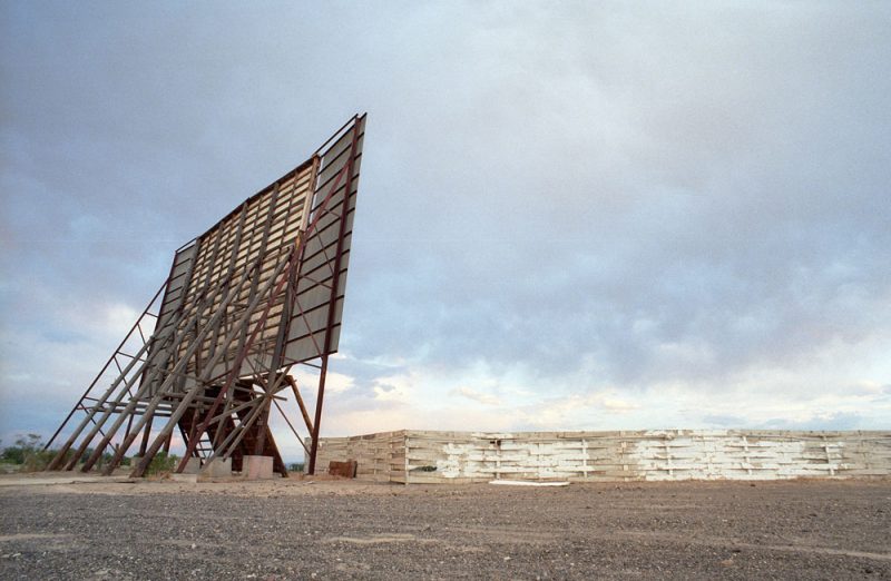
1. This old drive-in theater is outside of Fallon, Nevada, on the west side of town. I think it was between Fallon and Fernley, but I could be wrong. Fallon is a key town for me. It’s where US 95 and US 50 meet. It’s also close to I-80. Fallon was home to my favorite motel of all time – The Lariat – which was torn down years ago. I have rolled into Fallon many times after dark, knowing I could find a room to sleep in. It’s situated at the intersection of two major highways, each of which leads to many places I love. You can go east and find yourself in the prime hot spring country of central Nevada. You can go northwest and be in the Black Rock Desert. South takes you to Death Valley and Las Vegas. And west takes you to the Sierra Nevada Range, the Donner Pass, and the Golden State.
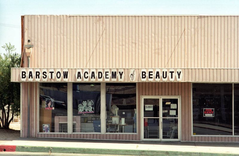
2. Some people might denigrate Barstow, California, but the town always has the last laugh. It’s hard to do anything in the Mojave Desert without passing through Barstow. I-40 and I-15 meet there. Old Route 66 used to run right through the center of town and the “historic” version of 66 is still there to explore. CA 58 takes you from Barstow to Bakersfield and then almost all the way to the coast. The lesser traveled, but spectacular CA 247 will take you down to Joshua Tree and there are local roads to travel, as well. As with Fallon, I have not found great food or coffee in Barstow, but I intend to keep looking. They used to have a Bun Boy restaurant, but I believe it’s now gone. I have had my share of car and tire repairs in town and photographed many of the old motels there. I should do a column one day just to honor the glory of Barstow. I have sat in an idling truck in Barstow many times, pondering where I should go.
3. Hanksville, Utah is a town named after Sergeant Ebenezer Hanks, who was born in upstate New York, but died in the settlement named after him. Hanksville is at the juncture of Utah Routes 24 and 95 – two roads that cut through some of the most fantastic topography in the whole United States. If you’re heading to anyplace in southeast Utah’s backcountry, there’s a good chance it’s on a gravel road that deviates from one of these two state routes. When I find myself in Hanksville, it usually means I’m on the way to or from a small campsite in canyon country. There are a couple of motels and there is some food and gas, so all of my needs are met here. This photo is not fair, in many ways, as I don’t remember taking it. I only know it’s Hanksville from the photos on either side of the film strip. I took the photo, but it feels like cheating. I guess some photos are like that.
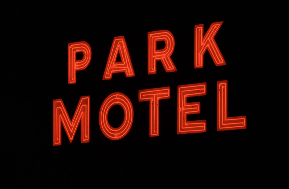
4. Homestead, Florida, in 1999. This motel was still open at the time, but I don’t believe it is now. The sign doesn’t turn on at night anymore. I make a point of checking on it every time I’m in southern Florida. Is it a crossroads? Sure, although it feels more like a culmination point. US 1 runs through Homestead, all the way from its northern start in Maine and on the way to its southern terminus in Key West. Florida State Routes 821 and 997 converge on the town and the Old Dixie Highway heads out to the northern end of Key Largo. Call it more of a gateway town but, either way, you’ll end up passing through Homestead if you’re down there and you’d better make sure you take the right turn.
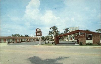
One way leads to the Keys, another leads north, still another heads to Miami and, finally, there’s a small road, imaginatively called “Main Park Road,” that will take you into the heart of the Everglades. I took this photo in 1999 and would look at it over the years. Somehow, in my head, the sign became towering and huge. The next time I passed through there, I saw that it was on top of a small, one-story building out back. You can see it in this old postcard (pictured to the Right). That happens sometimes. A sign will reveal its real personality in a photo, but it’s not always as impressive in real life. Which version is the true sign, though? I usually believe the photo.
5. I’m pretty certain this is from Ely, Nevada, but I’m not sure. Actually, I’m not so certain at all. The preceding photo – the first photo on this strip of film – is of an ancient motel and I’m not sure where that was. Then comes this photo. After this are a few frames from Austin, Nevada, on Highway 50, and then shots of Reno and the Black Rock Desert playa, so I know I was moving west. As with many of my film shots, hours or even days can pass between photos, so it’s *possible* this was taken in western Utah. Those mountains, though, remind me of Ely, pronounced “Eee—lee”, and I know that some tracks terminate or pass through that town. Either way, Ely is a crossroads town I pass through often and that’s reason enough for me to mention it here.
Ely is where US 6, US 50 and US 93 meet. US 93 runs from Wickenburg, Arizona to the Canadian border. US 50, part of the old Lincoln Highway, goes from Ocean City, Maryland to Sacramento. US 6 runs from Provincetown, Massachusetts to Bishop, California. It’s called “The Grand Army of the Republic Highway,” in honor of US Civil War veterans, but I don’t know anyone who uses that name. From Ely, you can get to Utah, Idaho or Oregon easily. It’s distant enough from other junctions that, whatever direction you choose, it’s a major commitment. Whichever way you turn, you’re likely to keep going, rather than return through Ely. It’s another town with no memorable food offerings, but it does have a large supermarket, what I would call a “ranch supermarket,” where you can get provisions or buy a money order for that traffic ticket you got on the pass coming in from the east. You know, that ticket where the trooper cited you for something called “Mountain driving” because your front tire happened to kiss the double line? Yeah, that’s the one.
6. This is from Gerlach, Nevada, famous now for Burning Man, but that’s not why I like the place. I stay away from Gerlach during Burning Man. It’s just not my thing. For the rest of the year, though, it’s a place I cherish. It’s far away, remote from everything. It feels like more than just a few hours from Reno. The closest “town” to Gerlach is the company town of Empire, just seven miles away. I don’t think Empire is a going concern anymore, now that U.S. Gypsum stopped operations. The main thing in Gerlach is Bruno’s Country Club, which is more like a headquarters for anybody coming through. It’s a restaurant, bar, motel and social reception area. It’s the Black Rock Desert Playa headquarters. When the Rocketeers are having their yearly gathering, they will hit Bruno’s on the way out to set up camp. Four-wheelers? Same thing. And random feral bands of untamed hot springs devotees? We could not pass through Gerlach without stopping at Bruno’s and topping off at the Shell station.
And what’s the main junction up here? That’s trickier to describe. If you have business up there, in that big blank space on the map, you know that it’s a psychic junction as much as anything else. You’re crossing from one dimension to another. Literally, though, it’s where Nevada Route 447 meets State Road 34, which goes straight up to all the good access points on the playa, then continues – all on gravel for 100 miles – up past Soldier Meadows, Summit Lake, and onward to the crossroads of Denio Junction. From there, you can get lost in the Alvord Desert of Oregon. You can also stay on 447 and find your way to Cedarville, California, then Alturas. And once you cross over that mountain, you can go anywhere. You can also take a fast gravel road from near Gerlach down to Susanville, but you need to know about it. There are few markings or signs at the gravel road junctions in northern Nevada. You want to make sure you always top off your gas tank and have enough drinking water and some food on hand. It helps to have some detailed topo maps. And it’s usually best to get where you’re going while it’s still daylight. When my friend Paul and I go soaking in hot springs, we usually have a rough plan that we can happily follow or deviate from.
If I had only put so much thought into most of my other life decisions, especially when I was in my 20s, I wonder what might have happened. I might never have traveled so many roads to this point in my life.
For More Photos, Click Here to Visit Paul’s Website: motelsign.com
To comment, scroll to the bottom of the page.
Zephyr Policy: REAL NAMES ONLY on Comments!

Don’t forget the Zephyr ads! All links are hot!


Thanks, enjoyed reading this. Love these kind of trips.
Those back roads and small towns are great places to travel. When I’m working in my wife’s shop, located on a non-Interstate road on the Hopi Rez, people ask me for directions and I sell them a copy of the “Indian Guide” map, whip out my professional grade yellow highlighter, and show them them alternative roads to their next destination in the four corners area. Vlachos is my kinda guy and his ramblings are one of the first things I go to in the Zephyr.