
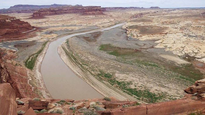
For the past three years, I have taken an active interest in drought in the southwestern US as illustrated by declining water levels in various reservoirs. I have been especially interested in Lake Powell which started filling in 1963 upon completion of the Glen Canyon Dam across the Colorado River and located near Page, Arizona just south of the Utah state line. Back in the 1980s when it was sometimes full, Lake Powell had a surface area of 266 square miles – the largest lake by area in the southwest. It is relatively narrow (less than a mile wide in most places) but quite long, extending 186 miles northeast of the dam to Cataract Canyon.
Over the past 20+ years, the water level and volume of Lake Powell have declined considerably. The U.S. Bureau of Reclamation located and designed the Glen Canyon Dam to maintain an elevation of 3700 feet above sea level, referred to as “full pool”. It took 17 years for this level to be first achieved in 1980, much longer than originally expected. The last year the lake level was near 3700 feet was 1999 and it has been erratically but steadily declining since then. At the start of spring runoff this year (May 25), the level had dropped to just below 3560 feet, 140 feet below “full pool”. The volume of water in the lake was less than 35% of its capacity. If that doesn’t indicate a serious, long-term drought, I don’t know what would!
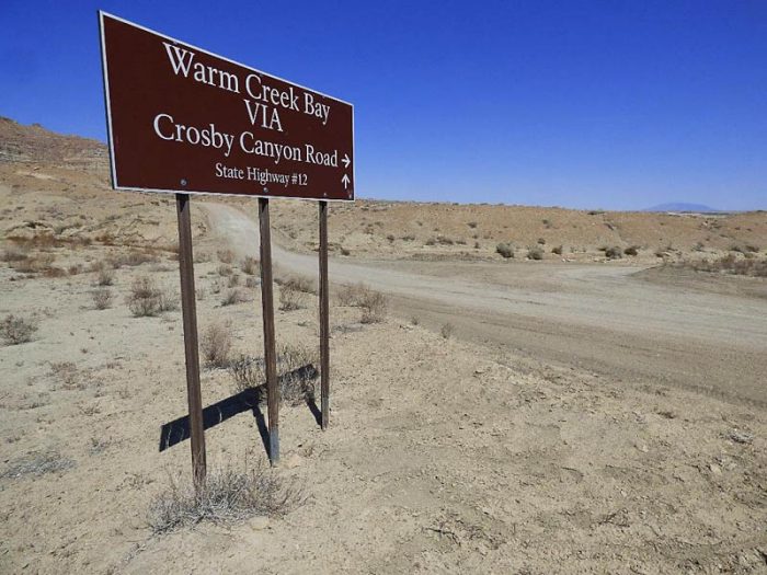
But these are only numbers so I will show a map and photos that give a dramatic feel for the extent of the changes both in Lake Powell and other reservoirs in the Colorado River Basin. In April 2021, my partner, Judy Greenfield, and I found a convenient access to the lake to see just how much it has changed in the past 22 years. We took a four-wheel drive road down Crosby Canyon leading to Warm Creek Bay, an arm of Lake Powell a dozen miles northeast of the dam.
We were able to easily drive a mile beyond where the 1985 topographic map showed the road ending at the edge of the lake at that time and we could have gone much further but decided to continue on foot. The solid grey line on the following map shows our route in our Toyota FJ Cruiser and the dashed line shows our hike to the present edge of the lake in Warm Creek Bay.
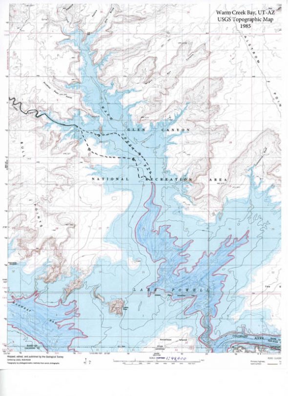
The light blue areas on the map show the extent of the lake at the “full pool” elevation of 3700 feet. The red line (following the 3560 foot contour) surrounding the darker blue areas shows the approximate extent of the lake in this area at present. I don’t fully trust the contour lines on the map below the 3700 foot area for some technical reasons.
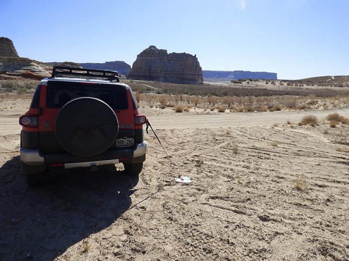
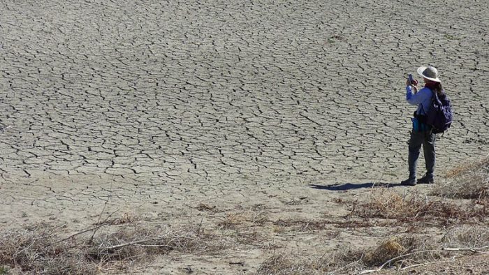
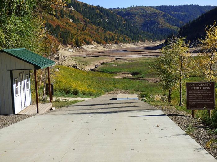
This is where we parked the FJ Cruiser at the start of our hike. It would have been submerged in some 50 feet of water back in the 1980s. Our route on foot went just to the right of the large sandstone tower in the center of the photo.
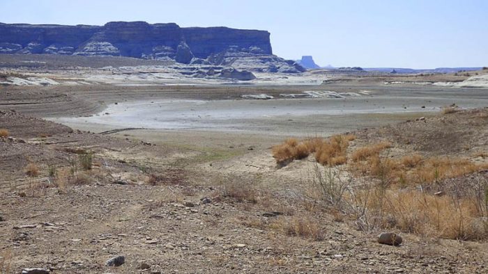
We walked about two miles before we finally got to the present edge of the lake. We noticed fresh water clam shells in the sandy soil along the way reminding us that water once covered our entire route.
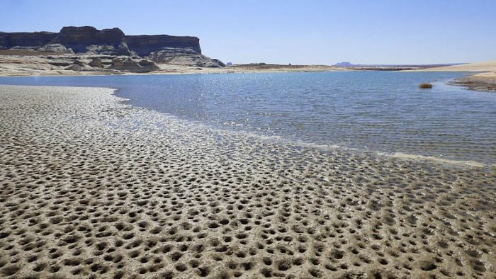
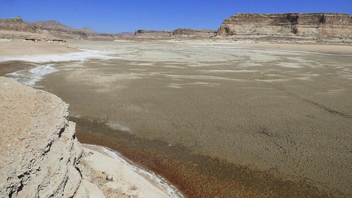
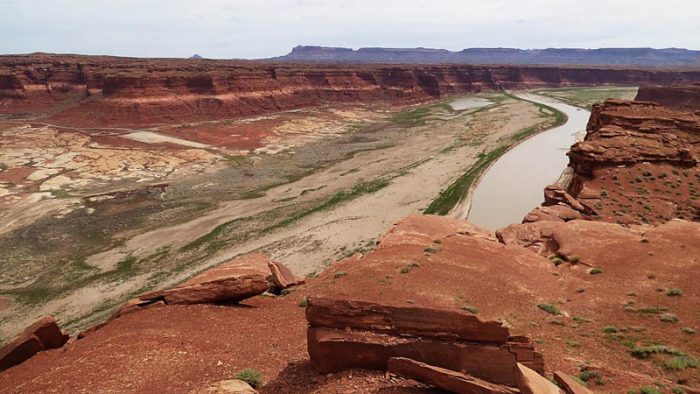
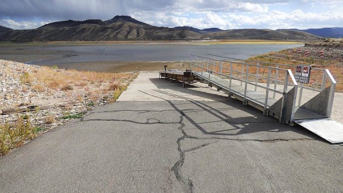
Next are a couple photos I took at the former site of the Hite Marina in April 2019, some 150 miles northeast of Warm Creek Bay. The Hite Marina was once a thriving boat launch and camping area. It is now totally defunct and abandoned because the lake level has dropped more than 80 feet below what is needed for the boat launch. The photos were taken on a cliff across from the former site of the marina.
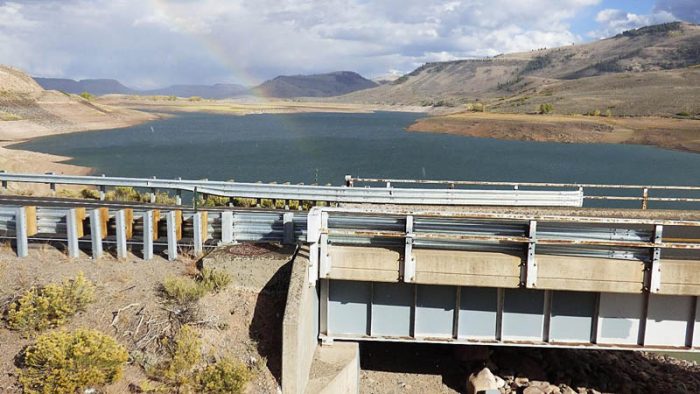
If you’re still with me, let’s take a look at two other reservoirs in the Colorado River basin above Lake Powell. The first is the Blue Mesa Reservoir, Colorado’s largest lake which stretches for 20 miles in the area between the towns of Montrose and Gunnison.
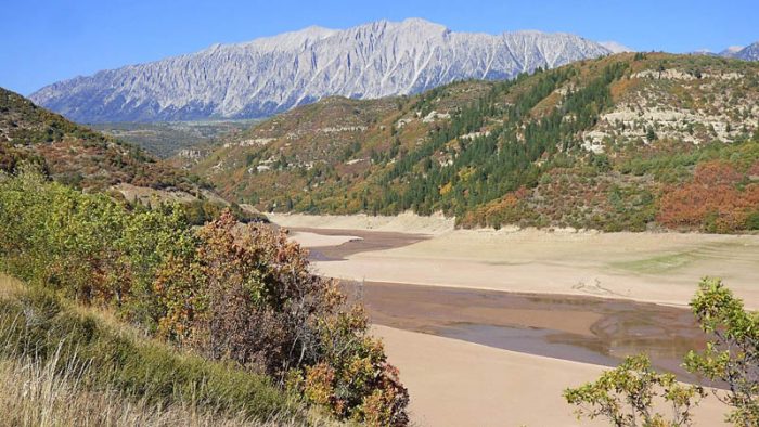
Finally, the Paonia Reservoir used to be a popular destination for boating, water skiing, and fishing in western Colorado. We drove along its shore last year on September 24.
So, in conclusion, why have water levels in Colorado basin reservoirs dropped so dramatically? Is it climate change and/or ever-increasing water use to serve a rapidly expanding human population in the region? It appears to me that both are in play but I’ll let the reader reach his/her own conclusions.
John Wesley Powell, the 19th Century geologist and explorer for whom Lake Powell is named, could have had no inkling of the 21st Century climate catastrophe. However, in his 1878 Report on the Lands of the Arid Region, Powell argued against massive migration to the arid West which he correctly believed could not support population densities anywhere comparable to those in the East. Of course, Powell was largely ignored due to greed and an irrational and unscientific exuberance for settlement of the West. And now, people of the Southwest are going to pay the price starting with central Arizona farmers and ranchers who are potentially facing a 65% reduction in their water supplies in 2022.
I do hope these photos have emphasized how bad the situation is, and I see no evidence that it’s going to get any better! And if the water level in Lake Powell drops another 35 feet, it will reach “minimum power pool”, below which generation of electricity becomes problematic. Hmmm, what then happens to the lights and air conditioners in Las Vegas?
Addendum
I wrote the first draft of this article two months ago. Since then, an anemic period of spring runoff raised Lake Powell’s water level only 1.9 feet. Since then, lake level declines have accelerated. On July 23, the lake surface dropped to its lowest level since it first filled more than 40 years ago. Dam managers along the Colorado River find themselves in a quandary. Were they to greatly reduce or even stop releasing water from the Glen Canyon Dam in order to stabilize Lake Powell water levels, they could nearly dry up the Colorado River through the Grand Canyon (with disastrous ecological consequences) and impacts to Lake Mead, some 300 river miles below Lake Powell, would be devastating. A steep decline in Lake Mead’s water level (already at record lows) would threaten an important source of the region’s water and hydroelectricity from the Hoover Dam. So instead, the Bureau of Reclamation has started releasing more water from upstream dams starting with the Flaming Gorge Dam on the Green River near the Wyoming-Utah state line. There are plans to increase flows from Blue Mesa Reservoir and Navajo Lake (on the San Juan River in northwestern New Mexico) later this year. However, without an end to the 20-year drought in the Colorado basin and a reduction in the demand for water, these measures will be, at best, only temporary fixes.
And yet while the Southwest “burns” from high temperatures and reduced precipitation, the politicians, bureaucrats, and citizenry continue to “fiddle”. Millions of clueless people continue to move to the region. Incredibly, Washington County in southwest Utah has proposed to build a 141-mile Lake Powell Pipeline to suck 28 billion gallons of water per year out of the Colorado River in order to nourish their bright green lawns and golf courses and maintain the skyrocketing population growth of the St. George, Utah area. They claim to be entitled to this water based on historic water rights. Where does the insanity end? Stay tuned for a wild, dry ride into the future!
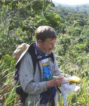
Will Mahoney is a senior environmental scientist with degrees in geography, geology, and environmental technology. He has worked on environmental impact assessments, audits, and inspection programs for energy projects. Will has also done environmentally-related volunteer work in West Africa (as a Peace Corp volunteer), Latin America, Arctic Canada, and the western U.S. Recently, he has been conducting water resources and soil erosion studies for the Southern Plains Land Trust in southeastern Colorado. Will and his partner, Judy Greenfield (an art conservator), have been hiking in southern Utah for the past 27 years. They live in Denver.
To comment, scroll to the bottom of the page.
Zephyr Policy: REAL NAMES ONLY on Comments!

Don’t forget the Zephyr ads! All links are hot!


as you intended (& as “the situation” intended): truly scary. i’ve (M-O-L) “been around” since the 1940’s and wish i could remember in all my life “the situation” recovering from something as bad as you’ve described … but can’t. “Enjoyed” (i’ll replace that word with, uh, “appreciated” — “made me continue to consider and mull and brace myself”) — your essay and the span of history/hystery included therein.
WOW. I had not a full idea that the situation was so bad. An extremely well-written article by a well-respected scientist. My only wish would have been to have 1 before/after photo really showing how far it has fallen. The map was helpful, but a photo would be better. Besides that, I learned a lot. Great photos and great article. Well done, Mr. Mahony! Keep it up and I hope to see more articles from you.
I have a photo taken by Stan “Mr Lake Powell” Jones taken when the lake was at full pool of a group of 60 performers from Salt Lake City in full dress attire. They had appeared in a concert in Page and, afterward, boated to Rainbow Bridge where they, at Stan’s suggestion, in defiance of the Park Service directive sang a number of patriotic songs to the delight of other visitors to the site.
Unfortunately I couldn’t download the photo to this reply.
One of the most memorable experiences of my life was visiting Utah on my honeymoon 30 years ago in 1991. Growing up in New York I’d never seen a place like Lake Powell. I remember marveling at it. To see it in the state it is now is tragic, especially knowing it is only one of our earths treasures dying from the climate crisis .
Thank you Will for your article and photos .
Will Mahoney’s article on the effects of the drought in the Southwestern part of the country struck a chord for me. There is a high likelihood of serious ramifications for Arizona farmers as well as many population centers going forward. Let’s hope this 20 plus year drought ends soon.
Perhaps it’s time to revise the 1922 Colorado River compact!!!! But try getting seven states to agree anything today. Further proof of the old adage “whiskey’s for drinking, water’s for fighting”.
A picture is worth 1,000 words. I had not been to the Hite marina since the mid-90s when it was an epicenter of wild youth on houseboats! Blue Mesa reservoir is now even lower than Will’s pictures.
But, ask yourself what caused the Anasazi to leave because of drought 1000 years ago? Perhaps the earth’s climate cycles have nothing to do with CO2 emissions. Certainly, analyzing the daily measurements from the Moana Kea observatory show that even though CO2 emissions declined 25% last year because of global shut downs, CO2 in the atmosphere dropped just 1/2000th. (not statistically significant given typical fluctuations).
The solution has to be market pricing for water. If you want a Golf Course in AZ, then it should cost you. And perhaps then, there would be sufficient economic incentive to revive the “Giant Straw” project to pump water from the Mississippi to the Colorado, for a mere $30 bn….but hey, that’s only 1% of Biden’s three TRILLION dollar Boondoggles, It would never be approved though, because it’s rational, and useful, and puts people to work.
Well done Will. I noticed one of the pictures in the article was taken while we were visiting Utah with you. Hopefully your great work will have an impact on those who can help a dire situation.
It’s so true that one picture is worth a thousand words! I have read many articles on our devastating drought situation, but never did I fully comprehend the gravity of the situation until I saw the photos. The camera doesn’t lie. Will’s magnificent photography is a powerful complement to his words of warning. We need more articles like this to make us truly aware of the magnitude and potential danger of the situation that we are facing.
Very well done article! I will forward it to other people to read. The pictures certainly make the point. Thank you for sending it.
Will Mahoney did a wonderful job of presenting the whole situation. Water , no water, not a drop to drink. Rain dances are in order. Very informative article….well done !
I really enjoyed your article about the reservoirs in our area. It is helpful to have others chronicle, quantify, and document these dramatic changes that we sense are happening. Thank you for your pictures and information Will.
Thanks for publishing Will Mahoney’s article. It is truly an eye opener for all to consider the results of climate change. For whatever the causal reasons, the results are indisputable. Great work Will, keep it up!
Will’s photo essay presents the stark reality of waterless vistas in a magnificent are od theAmerican Southwest. Having travelled the area for many years it has always been my delight to return again and again. Unfortunately, haven’t nen able to do so for about four years, but Will’s and Jennifer’s photorendition of vistas off the beaten path does justice to those concerned about the long term impacts of water depletion. One of the memorable events of the last 25 years were the immense water releases of the Colorado River of the 1980s – how long ago that seems and surreal in the context of current water capacity.
Thanks for having taken the time to write and update..
Wow, some hard hitting points here about the dire situation we now live in.
We need more articles like this to help educate the public which, in turn,
may help move things in the right direction for our country. Thanks, Will
Mahoney, for such an informative piece. Much appreciated!
Thanks to Will & Judy for all of their great photos. As they say “A picture is worth a thousand words”. As Will mentions, the plan to release water from the Blue Mesa Reservoir is currently in place. I think they are planning to drop the reservoir level by two feel a week until the end of September. There needs to be more accountability about downstream water usage. It’s like writing bad checks when you run out of money. Time and nature will soon combine to send a big wakeup call to the folks in the southwest. It’s happened thousand of years ago to other civilizations.
Thanks Will, well presented story of this cautionary tale. I appreciate the story the photos tell and the information that you shared.
Great article Will, the photos make it easy to understand and a great educational tool!
A sad tale, but one that needs to be told over and over again until we, as a society, learn from it. I am curious to know what you think the next steps are in trying to heal the landscape?
The devastation of much of the South West needs to be immediately addressed at every level possible- local, state and federal. As noted by Phil Varley in his comments above, getting seven states to agree on solutions may take a minor miracle. Making the public aware is a good place to start. This article should be spread far and wide as it graphically shows the situation without having to resort to charts and graphs. As a Coloradan, I was stunned by the photos of Blue Lake, although I had read about how far down the water level had fallen. The photos made it real. Thanks Will and Judy!
It’s a desperate picture you paint, Will.
Having grown up in the south of Namibia, I have experienced drought, but also learnt to appreciate the value of water. Water was mostly derived from brackish boreholes (a decent cup of tea was impossible!), and when it rained children would be out playing, singing and laughing. Water was truly valued. Then in the 70’s a large dam was built at Naute, in a valley at the confluence of 2 rivers, giving the local population their first taste of an abundance of water.
Unlike the situation at Lake Powell, the Naute Dam is relatively deep and serves a sparse community who should never experience water shortages again. Wildlife around the dam is proliferating, but sadly the children no longer dance in the rain.
Too much gets taken for granted, and us human beings have developed a fallacious sense of entitlement, especially when it comes to dealing with nature. I’ve been living in Ireland for over 30 years – it rains a lot! We get free water! A few years ago the Irish government tried to introduce water charges because the supply of potable water was struggling to keep up with an increasing demand, due to the ‘Celtic Tiger’. Protestors even held a government minister hostage in her car for a few hours. The loss of votes would be too high, and the government capitulated. We still get ‘free’ water. Free? Time will tell, but only once there is a crisis will we realise how much more rewarding it would be be proactive in our relationship with nature. Climate change will surely not play by ‘our’ rules. The sense of entitlement and an addiction to exploiting nature for short term gain just pushes our world deeper into the mire.
I met Will Mahoney when we were both living in Botswana in the 80’s. I appreciate his commitment to protecting our precious planet. Well done with your article, Will, and thanks to Canyon County Zephyr for publishing it.
As this excellent article and photos illustrate, we’ve reached the tipping point and must look for innovative ways to confront a water crisis that will likely be permanent. This may be one possible solution, at least for drinking water, although it doesn’t address agriculture and power needs or the overall effects of climate change: https://www.popularmechanics.com/science/a33594184/turn-seawater-into-drinking-water-using-sunlight/?utm_medium=social-media&utm_source=facebook&utm_campaign=socialflowFBPOP&fbclid=IwAR1umYT3pyGmtg7ZepZrhjxQ–ja1fg-IXwOWbYFClVU2r9mojAShKZyUOA
I am shocked! I thought I was well aware of the immensity of this drought. I had been to Lake Powell in the last decade and was amazed then by how low it was. Thank you, Will Mahoney, for writing it, and thank you to the publishers for making it known. What can we do? We cannot increase rainfall. It is likely to get worse, not better. The only solution I can think of is to reduce the impact of human population. Can we prohibit immigration to the West? Probably not, and that is fraught with its own problems. Can we reduce human fertility? It would take a massive information campaign to make people aware of the environmental impact of their perceived need for ever more children. But it does seem to be the only possible solution for a decent life for the next generation.
Will presents a sobering, impactful photo essay of the impact of climate change and increased population densities on the drought strickened southwest. Clearly changes need to be made to stem the impact of 20 years of southwestern drought. Do we have the fortitude to adapt to the pressure of the drought? Unfortunately, I doubt it.
Gary McIntyre, Ph, D.
Boy, I see lots of followup stories here. That pipeline, Las Vegas, and what’s up with Phoenix having the biggest population gain of any big city in the country? I’d be curious too at how the Colorado River looks as it leaves Colorado every year.
When I decided to move to Denver in 1975, I was another transplant from the east who was enchanted by the magnificent peaks. Since then, so many people have followed in my footsteps and settled everywhere from Denver to Vegas to LA to San Diego to Phoenix etc etc etc. Our arid land cannot bear this any more! I see real problems ahead for all of us in the West. Population growth and climate change are a real witches’ brew of eco-nightmares in our near future. I’m glad Will put together photographic proof of what I have known for a long time, but this really brought it home.
Wow, sad to see how far the lakes had receded. Water is life, without it we are done. Thanks so much for the enlightening article.
Splendid job! Major Powell (who foresaw this long ago and is turning in his grave) would be proud of you. We have to face the reality that megacities like Phoenix and Vegas were never “meant” to exist in places without the water resources to sustain them. We also have to face up to the broader overpopulation of the country. We need mass immigration like we need cholera.
Thanks for the article and pictures by my good friend, Will Mahoney. I was aware of the situation at Lake Powell, but always interesting to read other views of what is happening. I concur with your comments. Keep up the good fight.
Excellent article with great photos on Lake Powell that is now at an all-time low since it was filled! In June 1983 the lake almost overtopped the dam taking out concrete spillways. Heroic efforts by engineers saved it. I visited the dam a few years ago and asked the young guide if she knew that. She was aware of the incident but it was not something brought up during the tours.
These pictures need to be shared with a wider audience. Seeing these photos takes something that can feel theoretical and makes it concrete. Please continue publishing stories like these. As a person who cares deeply for the Colorado River ecosystem, these photos are heartbreaking. We need to share them with a wider audience in hopes of education, policy change and preservation.
Will Mahoney’s article and pictures provide compelling evidence of the dire drought in the southwestern US. More focus needs to be placed on this environmental issue to alert the public before it becomes an irreversible tragedy.
Visually impactful and sobering article—I can only hope that we can change the direction of the future.
Good review of the situation, and interesting personal examples and photos.
Note, though, that the levels in the Colorado reservoirs, such as Blue Mesa and Paonia, vary a great deal year to year and season to season. There is not a long term trend in these toward emptying.
Really nice work Will. Haven’t been down to that part of the world for a while, but the pictures are amazing. Excellent illustration of the drought and water use conditions.
Great article Will – and the pictures are compelling. I know the Bureau of Reclamation has recently declared a water shortage for the Colorado River, which means cutbacks for the foreseeable future. So far, there is only an acknowledgement that states need to “figure out strategies”.
To be fair, Paonia Reservoir looks like that every year in the laste summer and fall. Maybe its a bit sooner than usual, but the reservoir is intended to drain nearly completely for irrigation in the North Fork valley.
What a great, if depressing and alarming, travelogue. Thank you. I hadn’t known about the pipeline planned to pump water to St. George. Argh!
Since its publication the issue has gotten some prominent treatment in the NY Times and Wash. Post, if others are interested. A less intimate perspective, but also interesting and informative. Indeed, what the authors here forecast about restrictions has come to pass to a degree already.
The original Times article headline, “Climate Change is Killing the Colorado River” is a bit inaccurate: it’s more realistic to say “climate change and collective human stupidity, greed, and depravity” is killing the Colorado…and a lot more.
https://www.nytimes.com/2021/08/27/sunday-review/colorado-river-drying-up.html
https://www.washingtonpost.com/nation/2021/08/16/colorado-river-water-cuts-drought/
I hope the publishers/authors don’t mind the links to competitive news sources…
I can imagine few greater examples of humans pushing an environment past its carrying capacity than the images of a dying reservoir. Such hubris!
Powell was right – the land west of the 100th meridian was never meant to sustain such populations. Stegner well noted the reason for the vast expanses of the West – that organisms developed according to the allocations of moisture, thus are spaced far apart to make the most of the meager allotments.
Time to get the message to the various chambers of commerce throughout the West that it’s full, time to hang out the “No Vacancy” sign.
Sobering information and pictures.
Important documentation—impactful, sobering. Keep up the good work, Will!
Make no mistake. Today a reservoir’s primary function is recreation, not storing water. And the future be damned. Researchers have known for a long time that there are far more expedient & less wasteful ways to store water, if that’s the real goal. Underground, for instance.
Hundreds of years ago the indigenous population in many parts of the U.S. Southwest knew how to store water underground even though they lacked sophisticated hydrologic knowledge. There have been numerous ecological papers that have noted these practices. One in particular titled, “Social Implications of Pueblo Water Management in the Northern San Juan,” by Arthur H. Rohn, states the following regarding Pueblo III practices on Mesa Verde: “Completely artificial reservoirs, exclusively for water storage, occur at several large village sites…Water was brought to these reservoirs over distances up to half a mile.” “Much of the water that would normally rapidly run off down the canyon would be caught behind [a manmade] dam, soak into the underlying ground, and travel through the subsoil sandstones…”above an impervious shale lens, then exit through a spring. In fact, most of the water was stored underground, not on the surface. What was clear to the researcher is that it took considerable cooperation by individuals in order to operate such sophisticated systems of elaborate check dams and supporting hydrologic features.
Cooperation seems mandatory if any plan to preserve this most precious resource on our planet is to succeed. I fear that such altruistic hopes are long ago dashed by greedy developers and do-gooders at odds over how to undo this impending disaster.
Fallacious sense of entitlement sums it up! Utah population growth along with the entire west is out of control. Greed and wealth have overcome any common sense. And the fearless leaders in charge tell their constituents to pray🤣🤣🤣🤣
Very well done article. I’ve said for years in our arid climate each home should have minimum 1 acre lot. ZERO high density housing. If you limit the number of people you don’t outpace your resources but the almighty dollar wins. I fear for future generations.
“The Big Thirst, The Secret Life and Turbulent Future of Water” by Charles Fishman should be required reading for anyone who manages water: municipalities, government agencies, and private enterprise. While the book was published in 2011, it is even more relevant now. The author claims that, “Knowing what to do is not the problem. The hardest part is changing our water consciousness”.
Jim, this was an upsetting story. Having been there, it is sad to see something so beautiful diminish. The photos show the devastation of the drought and what used to be. My parents, my husband and I had once talked about renting a boat to tour the lake and unfortunately never did.
We tinkered with Mother Nature and dammed up water that was not meant to be dammed up and expected Mother Nature to never change again and be constant to provide all our power and water needs. When it does change we call it a climate catastrophe, to which it is not; it’s a man made catastrophe. This was a disastrous mismanagement of resources blamed on climate change so they can con you out of more of your money and resources.