
Two months ago, the Zephyr published my photo-illustrated article focusing on the effects of the current drought in the Colorado River Basin. My photos from Lake Powell, the Blue Mesa Reservoir, and the Paonia Reservoir showed the dramatic effects of declining water levels and seemed to generate considerable interest among Zephyr readers.
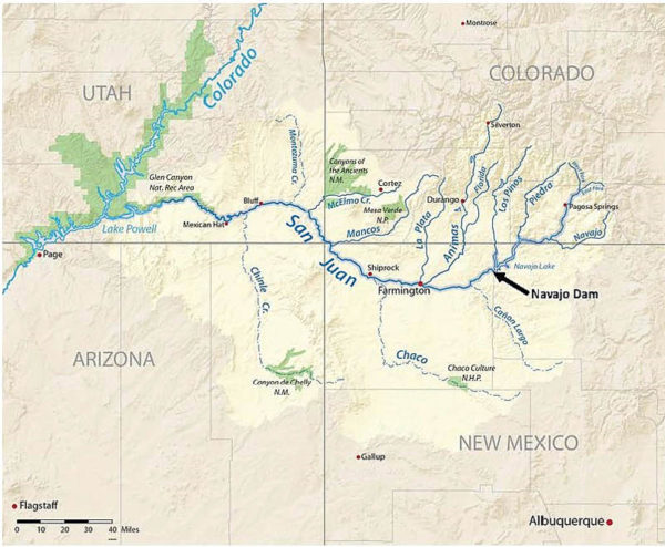
As a result, I was inspired to head out with my camera to explore the drought’s effect on two additional reservoirs in the Four Corners area which release water to Lake Powell and the Colorado River. The first one I visited, Navajo Lake, was created in the early 1960s by construction of the Navajo Dam across the San Juan River in northwestern New Mexico. The lake extends approximately 35 miles northeast from the dam into Colorado. The northern end of the lake in Colorado and the southern end including the dam in New Mexico are accessible by public roads. The middle section crosses remote Navajo Reservation land and is only reached by boat or oil and gas field access roads. To drive from Arboles, Colorado near the north end to the dam requires following winding paved highways for 45 miles. Following is a map of the San Juan River basin showing the location of Navajo Dam and Lake.
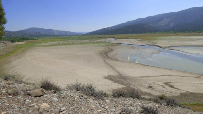
My first stop was at the Arboles Point Campground which is currently at the upper end of the lake. When the lake was sometimes at or near capacity in the 1980s and 90s, it stretched another five miles up valley from Arboles Point. In this photo looking east up the San Juan Valley, you can see where the small river currently flows into the lake. All the light green and sandy areas were once covered by lake water but the lake is now 56 feet below full capacity.
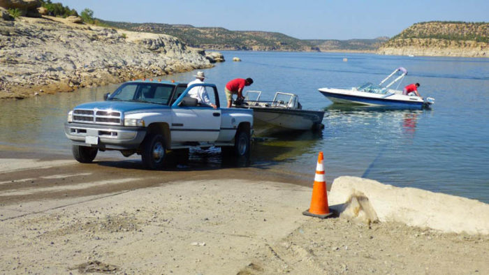
Next, I drove 9 miles around an arm of the lake to the Two Rivers Marina which has the only boat ramp and docking facilities at the north (Colorado) end of the lake.
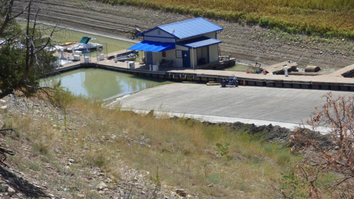
The boat ramp has five lanes. However, current low water conditions enable only two lanes to be used according to a Colorado Fish and Game ranger I spoke with. He said that every morning, employees scrape lots of mud off the concrete ramp where the water has declined a couple more inches. Note the strand lines behind the small building which show the past higher lake levels. The dock is on flotation drums which rise and fall with the water.

According to the ranger, large house boats are normally able to operate on the lake until late October but this year, owners were pulling them out in early September. They wanted to get them out of the lake before the water level dropped so low that they would not be able to use the boat ramp to retrieve them. In summary, he noted that the situation is “not good”. I saw several dozen huge house boats like these in a dry storage area.
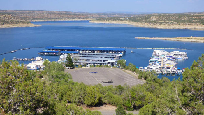
Nearly an hour after leaving the Two Rivers Marina, I arrived at the Navajo Lake Marina near the dam in New Mexico. This marina dwarfs the Two Rivers facility with its rows upon rows of pricey power boats. The view is to the northeast toward Colorado and the dam is about ½ mile to the right. Down on the docks, I was serenaded by loudspeakers playing Jimmy Buffett (I don’t know where I’m a gonna go when the volcano blow.) But since it was the Tuesday after Labor Day, there were few boaters around to maintain a festive party atmosphere.
A few people were launching and retrieving small boats. Because of the deep water here near the dam, I’m guessing that the Navajo Marina faces less risk from declining lake levels than Two Rivers at the upper end of the lake.
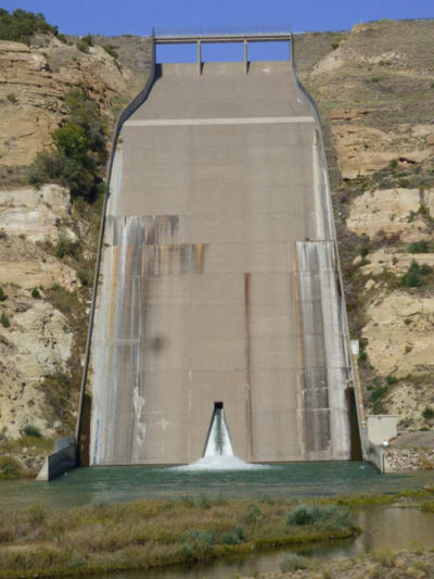
At the base of the Navajo Dam, water is being released at the rate of 765 cubic feet per second (cfs) on the day I snapped this photo. The U.S. Bureau of Reclamation, which built and operates the dam, upped discharges from less than 400 cfs in June to 800-900 in August. The Bureau has decided it needs to release more water from the Flaming Gorge Reservoir (on the Green River in Utah), Blue Mesa Reservoir (Gunnison River, Colorado), and the Navajo. The purpose is an attempt to slow the steep declines in the water level of Lake Powell which lies downstream. Power generation capability at the Glen Canyon Dam on Lake Powell will diminish if the lake level drops another 25 feet. However, flows from the Navajo are the smallest of the three and only account for about 15% of the inflow to Lake Powell.
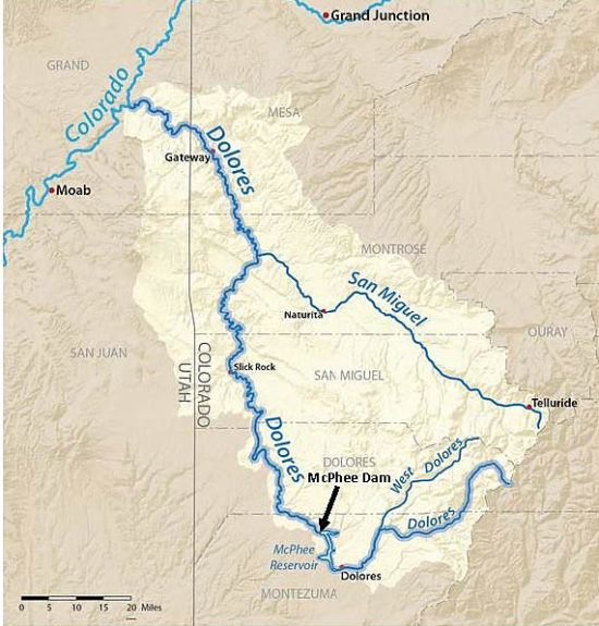
The following day, I headed northwest to Dolores, Colorado at the upper end of McPhee Reservoir on the Dolores River. Following is a location map of the Dolores River Basin showing the McPhee Dam and Reservoir.
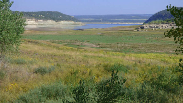
The reservoir has retreated about two miles north in the last couple years. In this photo, the lake is seen beyond the former lake bed now covered by emergent grasses. Since early 2019, the lake has dropped about 65 feet. Interestingly (or shockingly), the lake levels are currently dropping about one foot every five days, but unlike Navajo Dam, the declines are not connected with large releases of water from the McPhee Dam.
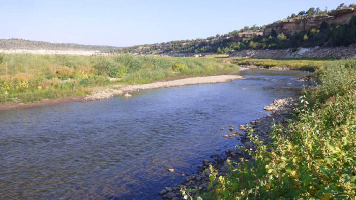
About one mile above the current upper end of the reservoir, the Dolores River was flowing at 44 cfs the day of my visit. This is relatively pure water from high in the San Juan Mountains south of Telluride, Colorado.
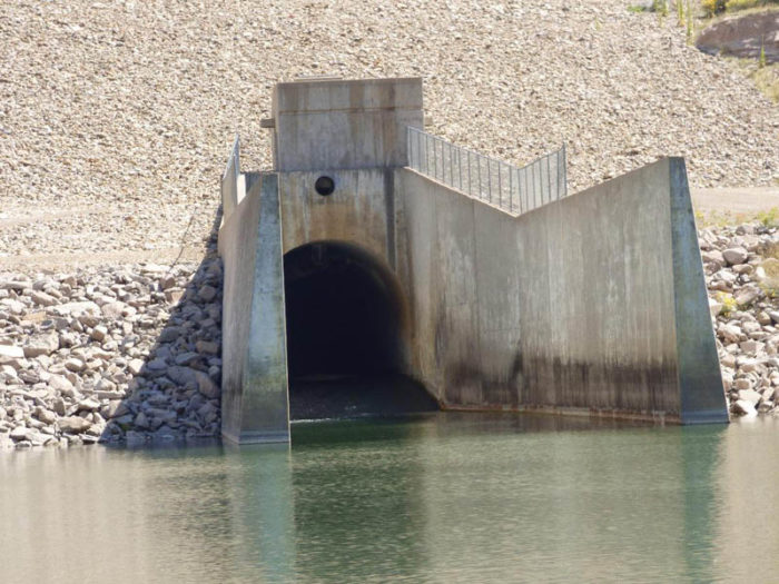
And here is the trickle of water (only 5 cfs) emerging from the base of the McPhee Dam several miles downstream. Because that’s only 11% of the water flowing into the reservoir, you’d think that water levels would be increasing. In fact, the reservoir went down ¼ foot the day I was there. Where is the water going? Certainly some must be loses due to evaporation. The day of my visit was sunny with a high of 89.
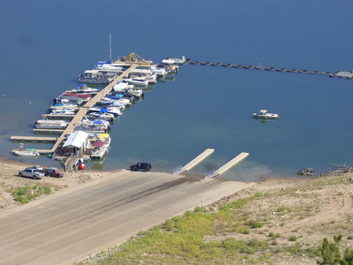
The surface of McPhee Reservoir is now at its lowest level since it filled in the mid-1980s. And the effects on the water recreation there should be noted. This is a photo of Doc’s Marina including the 6-lane boat ramp. I spoke with a none-too-cheery Doc’s employee who told me they were going to shut down the ramp when the water dropped another foot and a half. At the current rate of decline, it would have closed about a week later.
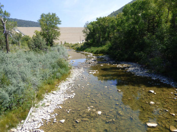
So what good is this damn dam anyway? It’s not maintaining water levels needed for boating. And it’s a fiasco for the water quality and flow regime of the Dolores River. This is a photo of the pathetic Dolores below the dam (compare it with the photo above of the pristine Dolores above the reservoir). That water you see is practically stagnant – there is little perceptible flow. No self-respecting fish would or could survive in such a degraded aquatic environment.
A bit of internet research turned up articles in two Durango, Colorado newspapers where I learned the fate of much of the water that flows into McPhee Reservoir. Some provides municipal water to local towns such as Cortez through a tunnel from the reservoir. However, the bulk of the water is diverted through a canal for agricultural irrigation. The Montezuma Valley Irrigation Company, which provides water to local farmers and ranchers, and other agricultural interests hold the senior water rights to Dolores water. Much of this irrigation water is used to grow alfalfa and corn which provide feed for cattle. We might give some thought to the effects of ranching on rivers and ecosystems in the West the next time we bite into our juicy hamburgers or succulent prime rib.
But it’s not just the ranchers. Everyone in this part of southwestern Colorado seems to want a piece of the Dolores – officials in sprawling towns, second home developers, recreational boaters, fishermen, ranchers/farmers, water-consumptive industries, and white-water rafting businesses. The irony is that demand for the foolishly over-allocated water is going up but the supply is drying up. For example, the water level of the reservoir is now so low that canal diversions for agriculture are threatened. Poor ol’ Dolores has given all she can and is now dying. In the process, she is exacting her revenge on human greed and short-sightedness.
In its journey below the dam, the Dolores flows through gorgeous canyons in remote areas of the western edge of Colorado before joining the Colorado River at Dewey Bridge, Utah, upstream of Moab. It’s absolutely criminal that this river is being destroyed. My pipe dream is that the gates in the McPhee Dam are miraculously opened letting the reservoir slowly drain so that the delightful Dolores is allowed to flow free once again.

Will Mahoney is a senior environmental scientist with degrees in geography, geology, and environmental technology. He has worked on environmental impact assessments, audits, and inspection programs for energy projects. Will has also done environmentally-related volunteer work in West Africa (as a Peace Corp volunteer), Latin America, Arctic Canada, and the western U.S. Recently, he has been conducting water resources and soil erosion studies for the Southern Plains Land Trust in southeastern Colorado. Will and his partner, Judy Greenfield (an art conservator), have been hiking in southern Utah for the past 27 years. They live in Denver.
To comment, scroll to the bottom of the page.
Zephyr Policy: REAL NAMES ONLY on Comments!

Don’t forget the Zephyr ads! All links are hot!


Thanks for the enlightening first hand report on a sad situation.
Scary indeed. Thanks for the fine reporting.
Keep up the good work! El rio Dolores tiene muchos dolores….verdad.(Photos from Calif. are even scarier, if that’s possible
Timely and important. Thank you.
Thank you for your good work keeping this issue before us.
Thank you, Mr. Mahoney. Such a good writer. I really feel you have made me realize how bad this situation is. I hope the legislators can now, with your fine photos and writing, do something for long-term relief. Thanks again. Please keep the articles coming.
I now have a better understanding of the situation at hand. Great pictures ! A definite need is at hand and the problem needs help.
These two articles are so simple and direct. I am not a geologist or hydrologist, but the evidence is right there in front of our eyes. It’s really scary. I was going to say I don’t know what will happen, but I’ll go ahead and predict a very major water crisis unfolding from now into the forseeable future.
Thanks for trying to wake people up, great read.
Another well documented article Mr. Mahoney. Unfortunately, I seriously doubt that you will need to write any more of these articles 20 years from now.
Thanks for your insightful work. I am looking forward to future articles.
We need to make this information widely available to the general public. We must conserve water, stop climate change, and decrease the multiple draws on this finite resource.
This really brings home how serious our water crisis is. This should be published in all media so that all may see it and take steps to reduce water usage and wastage.
Thank you Will for illustrating with your words the story that is also told beautifully in your photos. The reality of the coming water shortage becomes clearer with each example. The trend is there for each of us to see. How we respond is the next question to consider. Keep up the good work, I am interested to hear more. Are there any examples of a hopeful response to this situation? signs of conservation at least. Maybe farmers that are changing crops to favor drought resistant crops…
Beautifully written! I’ve wondered (for years) how they monitor water rights- what developer’s & ranchers actually pull from our rivers, streams, irrigation ditches? I appreciate your discussion on this important subject to the West! Thank you.
Thanks for another enlightening article about human short-sightedness in their treatment of Nature. We now see the effect of the endemic abuse of Nature. We should take nothing for granted, the world has changed, and we have a lot of catching up to do. It’s a cultural issue, as Will Mahoney alludes. Humans have nurtured a sense of entitlement and disregard when it comes to Nature. Every cause has an effect, and Nature is feeling the strain – water is a more valuable resource than oil.
Excellent report and photos…..so appreciated to better understand
such an important issue!
Thanks again for publishing another of Will’s insightful articles of the reservoirs that are all around where I live and recreate. I have seen these declining reservoirs firsthand, but appreciate Will explaining more of what I see happening. Keep up the good reporting on such an important topic.
Another great article by Mr. Mahoney! The straight forward writing paired with the photography hammers home this issue that impacts us all.
Thanks, Mr. Mahoney. There has to be a better light shone upon this ghastly environmental and socio-economic problem, though unfortunately I think we’re all mostly just preaching to the choir on these issues. The people most able to make an impact are ironically the ones that are least likely to, often because they stand to lose something along the way. Votes, money, whatever. The modern West has gotten itself into quite a pickle, made worse by these folks, city councils, and companies that exploit The Now while giving no thought to The Immediate Future. They don’t care because when it dries up, they’re just gonna pull up stakes and take their business elsewhere. If they think about it at all, they maybe imagine they’re gonna “pivot their business model” or some such nonsense. They could maybe do something about it if they all banded together, but for a variety of reasons, that’s not gonna happen either. No money in THAT. So they buy rental OHVs instead of rental boats next year, and shift their exploitations to dry land. There has to be a better balance to be found in balanced use…
I believe ol’ one-arm Powell warned us about this a while back.