
AND SOME SALVAGED REMNANTS FROM THE ALMOST FORGOTTEN PAST… NOW RESIDING IN THE ‘STILES COLLECTION.’
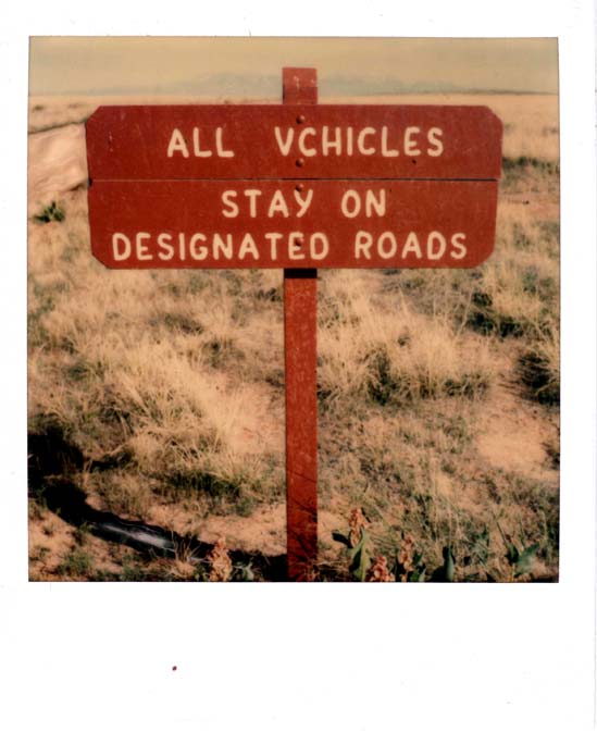
For decades, the iconic routed wooden signs, in national parks across America, were a familiar sight to tourists. They were works of art and I can’t think of anyone, whether they were just passing through, or if they lived in the area, or if they worked for the National Park Service, no one that I can recall, ever said or even thought, ‘The signs are pretty, but they’re just not efficient enough. And they’re not reflective!’
Since the speed limit in national parks rarely exceeds 45 MPH, and since the traffic in many parks is so crowded to the point of gridlock vehicles are often lucky to be moving at all. And it’s true; the old routed wooden signs had no reflectivity, but they sure were pretty. Nobody complained. Everybody was happy. There was no problem.
But leave it to the government to find one. Someone in the Department of Transportation, his/her identity lost to history, decided to take a look at the park signs and saw red flags everywhere. Maybe he was on vacation, but failed to noticed the majesty of the Grand Tetons or the surreal beauty of the Grand Canyon. I’m just fantasizing here, so don’t quote me, but who knows? Instead of being moved to tears by the Beauty of it all, he was brought to his knees by something else…
“These signs! These signs are NOT in compliance with federal highway safety standards!!!”
Oh…NO.
By 1978, national park areas got the news. All the old wood routed highway signs had to go. The DoT had regulations in place and now the parks had to comply. The size of the sign itself, the size of the letters, the height the sign must be above ground level, the reflectivity of the sign — All of these new standards must be complied with. The Park Service, and Arches National Park specifically had no beef with the signs. If there was any blame to be cast, it was their willing compliance with the changes. I don’t recall the procedure that followed or whether Department of Transportation toured all the parks to take measurements. I was a lowly seasonal ranger and not part of any decision-making process (except when I made decisions without permission and got away with it).
But there was one action I could take that was legal and necessary. Even by the late 1970s, I had sensed that the entire rural west was changing, that we were on the cusp of a major transformation. My dad had been something of a photo-documentarian and I had naturally followed in his foot steps. I had begun aiming my camera at old dirt roads, soon to be paved. old buildings that would soon be razed. Even the small Western communities themselves. Now, I thought, I need to get out there and take pictures of these signs before they vanish ad end up in the park boneyard (A dump of sorts). It was a bittersweet project.
What follows however, is more than my photo sign project from 1978-1981. Over the last 25 years, other Zephyr readers, who share my love of history, contributed thousands of images and have made this publication a worthy outlet to explore and see the West as it was. Herb Ringer and Edna Fridley contributed greatly to this effort. (Note, it was Edna’s daughter Marti, who gave me her mother’s Kodachromes, a few years after Edna passed.)
And there was another source. Not long after I became a ranger, I realized that the park infrastructure had changed dramatically over the previous 20 years (1956-1976). The new road sometimes diverged from the old right of way. Old picnic areas and campgrounds had been shut down. Old turnouts had been closed.
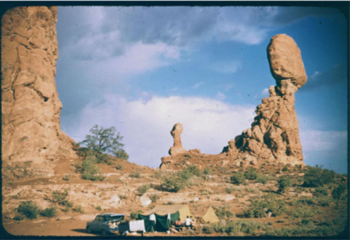
I had heard that at one time, a small campground and picnic area had been designated behind Balanced Rock. Even an old rusty can or broken bottle interested me, so I stopped to take a look, As I poked around in the black brush, something caught my eye. Half buried in the sand was a routed wooden sign. It had been mounted on an iron pole; some of the white lettering paint was still intact. I was downright excited by my find. I took the sign down to the visitor center and showed it to my boss. Jerry was impressed.
“Can I keep it?” I asked. Jerry said sure. he doubted it would find a cherished place among the exhibits at the visitor center. I took it home and still have it to this day. When you scroll down this story, you’ll see it. And the story behind it. And you’ll learn who made it.
It occurred to me, I wonder what else is lying out there in the sage and black brush and tumbleweed. Over the years, there was more than I thought possible. So here’s another “Zephyr Stroll To the Past.” I’ve posted the pictures in some kind of order. I started out on the highway, where the old park entrance once was, and where, in fact, you won’t see a sign, and through the original entrance station and the visitor center. Though they don’t meet the “sign” theme of this story entirely, both are gone now as well, and worth a look.
And finally, this is only Volume One. I have far more photographs than would fit in one post. So this installment takes you from the Arches entrance to the delicate Arch/Wolfe Ranch turnoff. With some diversions to the old and abandoned road, now long forgotten. Volume Two will come soon…
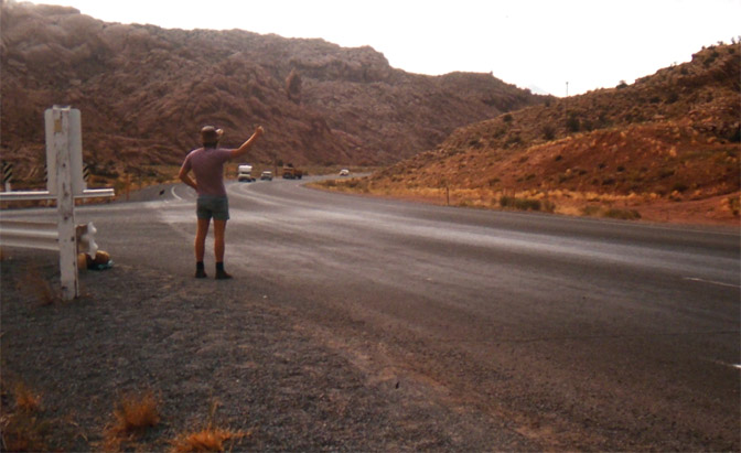
Until the new entrance station was built more than 20 years ago, the entrance to Arches was almost a mile further up the highway. The old CCC stone culvert, built before World war II, is still there, but rarely noticed. It deserves a story of its own. In the photo, a hitchhiker from Rumania waits for a ride. The official entrance sign to the park was across the highway, on the other side of US 191 (then US 163). It’s where the sand dune is. Like now, tourists stopped to have their picture taken in front of the sign, while their children risked life and limb, rolling down the massive dune. back when kids were allowed to do stuff like that.
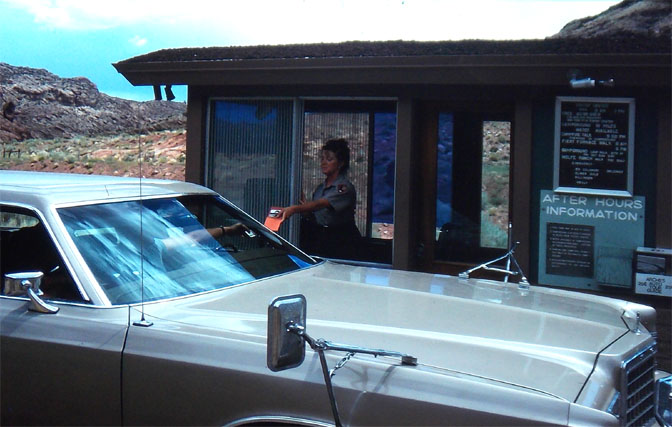
In 1978, the traffic was slow enough that a book could get read while waiting for the next customer. That woman handing out a brochure was, I think, my first ex-wife. The biggest complaint by ES staff was always the fumes, not the numbers of tourists. But there was always time to close the window between cars and trailers and motorhomes, and recover from the carbon monoxide poisoning.
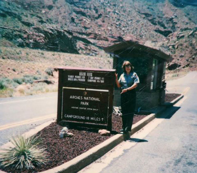
One of my favorite rangers. Kris Allen ran the ES for several years. Here she is showing off the new entrance sign. And with all due humility, I designed it. The larger part of the sign, the “ARCHES NATIONAL PARK part, could be rotated. On the other side was the “CAMPGROUND FULL” sign. I did a bit of research, and thanks to the regular flow of European tourists, we were also able to provide similar warnings in French and German. I still recall most of the phrase:
“Der Camping Ist Voll. Ubernachten Ist Forboten!”
Later Kris met and fell in love with the intrepid reporter for the Moab Times Independent, Bill Davis. They are still together all these decades later. A wonderful lifelong romance. Well Done.
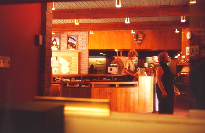
It was built in the late 1950s and served the public well for 40 years. The information desk floated in the middle of the main room, which gave better access to tourists who wanted to know where the rest rooms were (“Outside and to the left.”)
It was at that counter, in December 1975, when a fella came in to buy some postcards and a book. He asked if I’d take a check from a Green River bank. As he was filling it out, I glanced down and I believe I said something like, “Holy Shit! Are you Ken Sleight?” It was my introduction to “Seldom Seen.” Almost half a century ago. How is that possible?
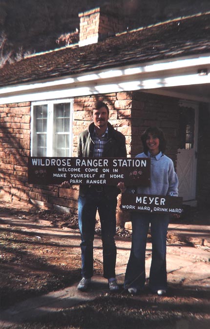
Mike & Val Meyer
The “Rock House” had been built in the late 1930s and was first occupied by Hank Schmidt, an early park custodian. It became the home of the Monument’s first superintendent, Bates Wilson, in 1949. Bates & Family lived there until his retirement in 1972.
(I recently posted the first in a series of stories and photographs by Bates’ son, Tug. To see his story, click here.)
Mike became chief ranger Jerry Epperson’s right hand man in 1978. He and Val were the last NPS staff to live there. After Mike was transferred to Death Valley — note the sign! — the home was gutted and turned into offices for the Canyonlands Natural History Association. Among the debris left in the front yard, and destined for the landfill, were all those magnificent knotty pine cabinet doors. You can probably guess. I asked Dave Baker, the maintenance chief, “Do you want these?”
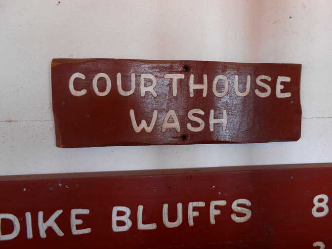
When the NPS started replacing the old signs with the new bigger signs, with more “reflectivity!” all of them were hauled to the boneyard. I know many of the staff helped themselves to what was left. I did quite well. Above is the old “Courthouse Wash” sign and part of the bigger Klondike Bluffs sign. But mages of it, in situ, will have to wait until Volume Two.
Photo credit here goes to EDNA FRIDLEY. She was at Arches not long after the new road was completed in 1958. But she also came bac in 1961 to take this picture,
THE STORY of EDWARD ABBEY’S SIGN
On May 22, 1956, Arches National Monument superintendent Bates Wilson made the following observation in his monthly report to regional headquarters: “The increasing desire of fools to carve their names in public places has reached the highest level possible in Arches.”
Just a few weeks earlier rookie ranger Edward Abbey had “EOD’d” (entered on duty) as a seasonal ranger. You know the story…Abbey was stationed at a small trailer near Balanced Rock. If anything, Abbey’s intolerance of “fools” surely exceeded that of his boss.
Abbey worked two consecutive seasons at Arches, during the summers of 1956 & 1957. We all know he loathed the idea of a paved and developed Arches, and he quit at the end of his second season. But in 1965, Ed came back for a third tour of duty. If you can imagine, he lived in the seasonal apartments, 7A.
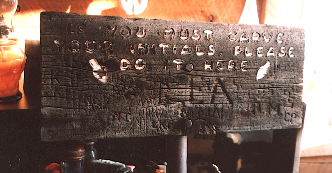
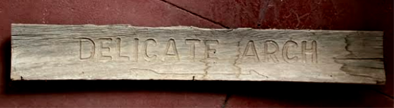
Jump ahead more than 20 years. Now a rookie ranger myself, I had wandered off the trail near Balanced Rock, probably trying to avoid tourists and fools alike, when I found an old faded wooden sign — the sign I mentioned at the start of this photo essay. It was still attached to a steel pole and the routed letters were legible. It said:
“IF YOU MUST CARVE YOUR INITIALS, PLEASE DO IT HERE.”
With NPS permission (!), I carried the old sign back to the patrol cruiser and later planted it in the soil in front of my new home. In the early 80s, I had purchased some cheap land in San Juan County, and using only hand tools (I really DID cling hopelessly to the past), I built a ‘rustic’ shack. (Think of ‘rustic’ as a euphemism.)
One day, months later, I heard Abbey pull up in his banged up Ford pickup. Abbey came by. But he didn’t immediately knock. I stepped outside and found him staring at my sign.
“Where did you get this?” Ed asked. He looked puzzled.
“It was lying out in the black brush behind Balanced Rock,” I explained.
“Of course,” Ed chuckled. “I remember that sign”
He furrowed a bit. “Wait a minute…Damn, I think I made that sign.”
Abbey explained that it had been an exercise in frustration, but it had helped for the moment. Later it occurred to me that “The Monkey Wrench Gang” was a later expression of the sign…a way to deal with inevitabilities. Many forget Abbey’s most accurate mantra. He said, “I don’t want to keep things as they are…I want things to be like they were.
Later, while I was away, he came back to my shack and left his “mark” on the sign he had made in 1957. Note the “EA.” Today it is one of my treasures.
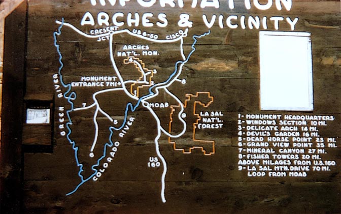
Chief Ranger Lloyd Pierson took the Kodachrome image above. The old entrance road junctioned with the main highway near Seven Mile Canyon, and the turnoff to Dead Horse Point. Though “headquarters” was where the park entrance is now, no one was stationed at the Seven Mile location. To the left you can see a brochure box.
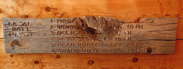
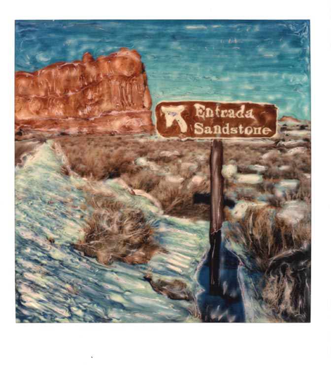
After I found the old sign at Balanced Rock, I wondered what else was just lying around. After I finally quit my ranger job, my visits to Arches were often to remote places that few others would be interested in. I particularly sought locations where there might have been a cowboy camp, or the remnants of a corral, or a smooth entrada sandstone wall that might reveal petroglyphs or cowboy and Basque inscriptions. On the west side of Salt Valley, on an old road that was closed decades ago, I found the old park dump and disposal area. It had been forgotten for ages. The last time I was there, I even found a concrete dynamite box with a padlock on it. But I also found a still intact portion of the Information sign. Bits of white paint even clung to the routed letters. It was heavy, but I lugged it back to my car. I still have it.
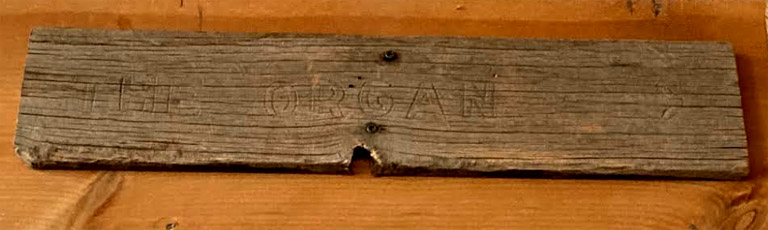
I found this lying in the black brush, behind the Organ in Courthouse Towers. It’s probably one of the oldest park signs still existing. Note that it wasn’t routed, but was “stamped” by some kind of tool.
THE EDWARD ABBEY TRAILER DEBATE
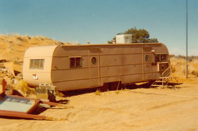
Ed Abbey fans have been debating the fate of his Arches trailer for decades. Some thought my tin trailer at the Devils Garden Campground was his. I even put a sign on the door that read: “This was NOT Ed Abbey’s Trailer.” A few tourists knocked anyway. One visitor, who somehow thought Ed’s 1956-57 time at Arches was a contemporary account, knocked on the door in search of Cactus Ed himself. In frustration, I said, “I AM Edward Abbey.”
He stared at me briefly and replied, “Really? I thought you’d be much taller.”
*****
As to these two photos, I have an almost photographic memory of everything that happened to me, good or bad. In most cases, I can recall dates and locations and names. But I cannot, for the life of me, remember the origins of the trailer pic. If it were possible to lose even more sleep than what I’m already sacrificing, I’d be losing even more of it trying to remember.
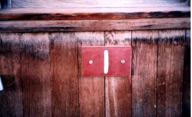
But whoever led me to the trailer was so confident it was THE REAL DEAL, that I believed him. Below, the small routed “1” was on the door. I still have it. And one note to Abbey Fanatics — somewhere I have seen a photo of Ed and his wife Rita (at the time) and their newborn son, in the doorway of a trailer that, I think, had the same circular window. But incredibly, I cannot find that photo either. If you know what I’m referring to, and have access to it, could you send me copy? (cczephyr@gmail.com)
Last time I checked, the frame of the old and original boundary sign was still intact, near Willow Flat. My recollection is that monument custodian Lewis T. “Mac” McKinney and his wife Alice constructed the sign in the late 1940s. I hope it has survived the World of 2024.
There were dozens of these signs in the park, on old roads that we kept trying to close. For an account of my first “bust,” for violating parks rules, and my subsequent introduction to Sheriff Heck Bowman in 1978,
“The Righteous Wrath of Ranger Stiles”
click here.
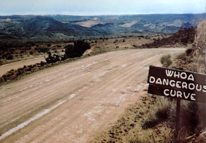
When I first came to Arches in 1975, I tried to familiarize myself with place names, both official and unofficial. I learned that after the Panorama Point turn off, the long grade that descended into Salt Valley, the Delicate Arch junction, and eventually to the Fiery Furnace and the Devils Garden, was called “Whoa Hill.” It was, for sure, a steep grade, and I could see the need to yell “WHOA!” from time to time, especially in government vehicles, but where did the name come from? Nobody among the Arches staff knew.
Then one night at the campground, I met a tourist from Minnesota named Charlie Kreischer. He had been down Glen Canyon in1959 and offered to send me some photos. True to his word, a box of Kodachrome slides arrived one day. Not only were they full of classic Glen Canyon images, it included other scenes from Southeast Utah, including this one.
Before the paved road, the original route dropped into the valley at a point west of the highway today. If anything, it was steeper and more hazardous. Who came up with the name, I still don’t know. But when the old road was closed and the new one opened, the name, unofficially at least, moved with it.
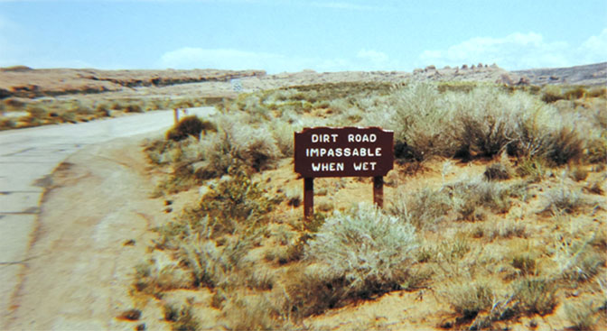
Until the early 1990s, the road to the Delicate Arch trailhead, Wolfe Ranch, and the Viewpoint, were unpaved. Superintendent Pete Parry quietly fought to spare it pavement and even proposed a “soil cement” mixture that he hoped would be weather-proof, but still maintain its primitive feel.
The road also had to cross three washes, which were passable when dry. But when flashfloods made their way to the crossings, forget about it. Still tourists dealt with getting trapped on “the wrong side” of the wash with good cheer. The road was rarely closed for more than a few hours.
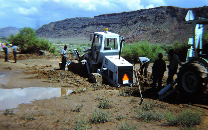
Then the NPS tried to make some “improvements.” Below is the result…
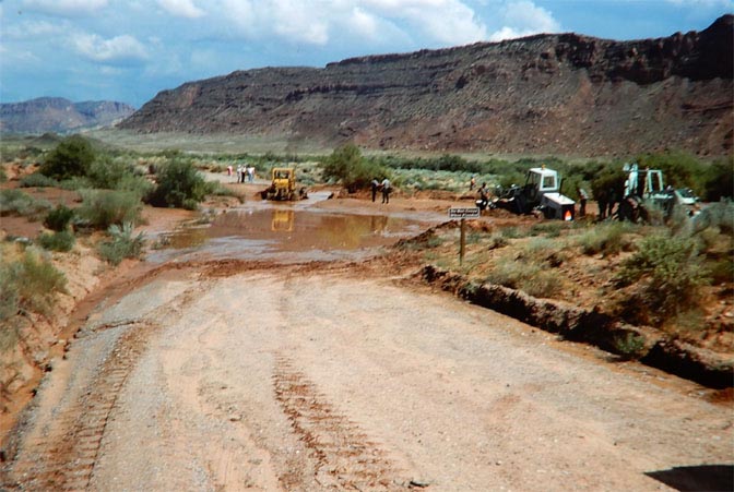
A particularly heavy flood closed the crossing for several days. Most of the NPS heavy equipment operators were wizards with a backhoe or front end loader. But not this guy. He started grading the wash downstream from the crossing; consequently and unbeknownst to any of them, he had changed the gradient of the water flow. Now the wash, fifty yards downstream was higher than the crossing itself. It was like an invisible dam.
The next rain, though not severe, caused the water to back up and pool at the crossing. At one point, access to Delicate Arch and Wolfe Ranch was closed for over a month. And the problem persisted. They were never able to get Salt Valley Wash to flow like it had for decades, at least not at the crossing.
This was the beginning of serious efforts to pave the road and build low water permanent crossings. Sometimes they STILL fight Nature for access.. In the end Nature ALWAYS wins.
Here is where I’ll pause for now. In Part Two, the journey continues, beyond Salt Valley Wash. What did the road and its signs look like in 1978? And beyond to the Fiery Furnace to the Devils Garden? Stand by for the next edition, in a few weeks.
*****
Jim Stiles is the publisher and editor of The Zephyr. Still “hopelessly clinging to the past since 1989.” Though he spent 40 years living in the canyon country of southeast Utah, Stiles now resides with two cats, Rambo & Rascal, on the Great Plains. Coldwater, Kansas is a tiny farm and ranch community, where there are no tourists.
He can be reached via facebook. Messenger, or by email: cczephyr@gmail.com
TO COMMENT ON THIS STORY OR TO EXPRESS AN OPINION, PLEASE SCROLL TO THE BOTTOM OF THIS PAGE. THANKS…Jim Stiles


And I encourage you to “like” & “share” individual posts.
Why they can’t just leave the site alone is beyond me,
but that’s what Facebook likes to do.
ALSO NOTE: I post old photographs and stories from our 25 year old archives every day. Pictures from Herb Ringer, Edna Fridley, Charles Kreischer.. even a few old photos from my Dad. So if you want to stay caught up on our historic photo collections,
be sure to “follow” us on Facebook…Thanks…Jim
https://www.facebook.com/FansoftheCanyonCountryZephyr/

$55 Each or Two for $100 (Free Shipping.)
https://www.facebook.com/profile.php?id=100086441524150


And check out this post about Mazza & our friend Ali Sabbah,
and the greatest of culinary honors:
https://www.saltlakemagazine.com/mazza-salt-lake-city/

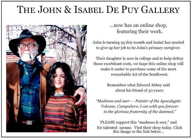
More than six years ago, The Zephyr, me & four other individuals were sued for defamation by the former Moab City Manager. Faced with mounting legal bills, my dear friends John and Isabel De Puy donated one of John’s paintings to be auctioned.
ALL the proceeds went to our defense.
Thanks to them, our bills were almost completely covered.
Now I’d like to return the favor. Check out the link below and their online shop… JS
https://www.depuygallery.com/


https://www.canyoncountryzephyr.com/
TO COMMENT ON THIS STORY OR TO EXPRESS AN OPINION, PLEASE SCROLL TO THE BOTTOM OF THIS PAGE. THANKS…Jim Stiles
Absolutely wonderful piece Jim! Thanks for sharing the pics and the stories. Priceless stuff.
Great read! Thank you so much!
Amazing that you’ve kept those old signs, which had to move when you did! Wish there were more people like you who preserved items from the best years of our lives!
I guess the packrats and me have a lot in common.
Love it! Those old signs reflect an aesthetic that in and of itself reflects (as Abbey said and you reminded us), the way it “were”.
“Between the artist and the bureaucrat there must always be a profound mutual antagonism.” –Bertrand Russell
Thanks for the trip down memory lane! Arches in the 70’s is a treasure to me.
Soon I’m going to repost that long shot of you, all by your lonesome, at the Delicate Arch trailhead. A busy day in 1976.
Awe .. Arches in the 70’s is a treasure to me. Thanks for sharing. Hope all is well!
I ALWAYS love these articles with old, mostly now gone, photos! I must have seen many of these signs when I first visited Arches in 1960 and ’61.
Thanks Jim, great as always
Love all the old photos, they bring back memories. The mired loader reminds me of when a Needles YACC ranger stuck a Bronco in Salt Creek quicksand and a maintenance worker managed to sink a loader trying to extract her. Had to bring a loader from Arches down to extract him. As woodcrafter/signmaker at Grand Teton NP I had fun making joke trail signs, like Beyond The Point Of No Return. I made most of the wood signs from redwood salvaged from an old water tank in S.E. Alaska.
That’s funny. The loader you see here in Salt Wash is proof the same one that came to the rescue in Salt Creek. Good story. Thanks.
Readers might enjoy the array of “modern historical’ petroglyphs in Joshua Tree National Park, known as Samuelson Rock.