
EDNA FRIDLEY was a good friend of southeast Utah for more than 30 years. In the fall of 1962, Edna set off on her last trip down Glen Canyon. The dam, 150 miles downstream, was almost complete. Within months the Bureau of Reclamation would close its diversion tunnel and stop the free flow of the Colorado River. Edna had been invited to join a party of friends to celebrate Harry Aleson’s wedding, which was to happen during the trip. She drove to Hite from Salt Lake City, via the old road. At the end of the trip she stayed in Page, at the Page Boy Motel, then arranged a flight to the dirt airstrip at White Canyon to retrieve her Ford Falcon. She took thousands of photographs of her pack and river trips with legendary guides Ken Sleight and Harry Aleson. The Zephyr will be featuring many of those photographs in a regular series called “EDNA FRDLEY—Exploring the Colorado Plateau (1956-1975). Edna also kept journals, often scribbled in small spiral notebooks. After her death, her daughter Marti gave The Zephyr her mother’s entire collection of photographs and journals. They are a treasure beyond words…
CHARLES KREISCHER and his wife were regular campers at Arches NP when I was a ranger there in the late 70s. The Kreischers had floated Glen Canyon twice, in the late 50s, while the dam was under construction. He was delighted to learn of my interest in Glen Canyon. A few weeks after their visit, a package came in the mail. Charles sent me more than a hundred Kodachrome slides of their journeys. They are some of the best images of the Glen I have ever seen.
I’ll be sharing more from both of them in the future...JS
In this selection of Kodachrome transparencies by Edna Fridley and Charlie Kreischer, I assembled the images as if one were traveling from Hanksville to the Hite Ferry, and then eastward through White Canyon, and past the Bears Ears, on the way to Blanding. The entire journey was about 140 miles. These pictures were taken by both photographers and at different times, between 1959 and 1962. I’ve done my best to assemble them in order, based solely on my recollection of the landscape after driving Utah 95 hundreds of times over the past 51 years…JS
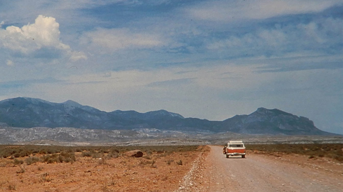
present day junction with the Bullfrog Marina road. Edna Fridley
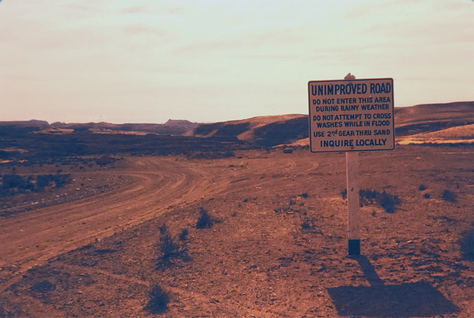
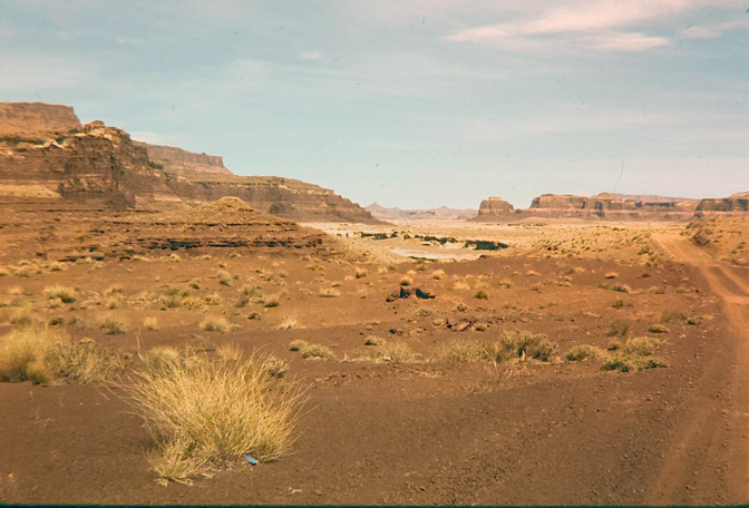
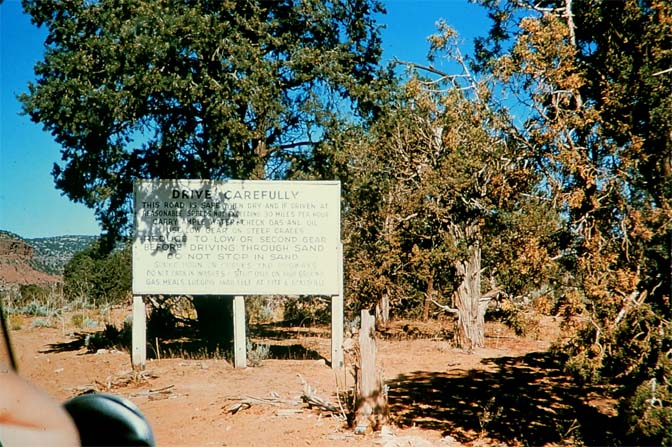
Any storm could wipe out dozens of crossings. Edna Fridley
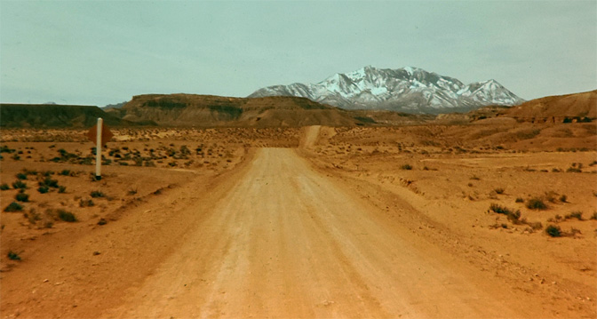
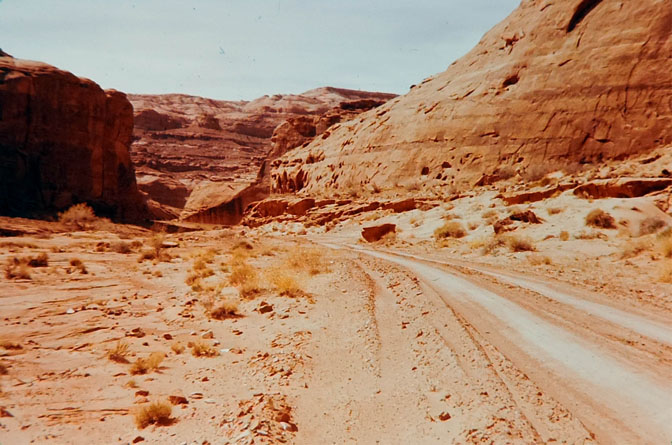
and make their way up North Wash.
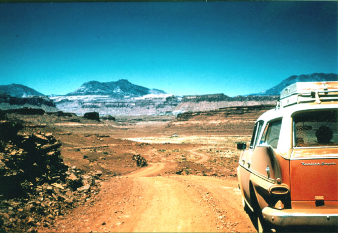
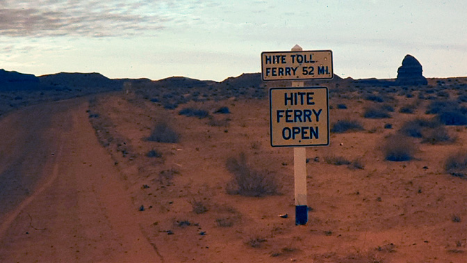
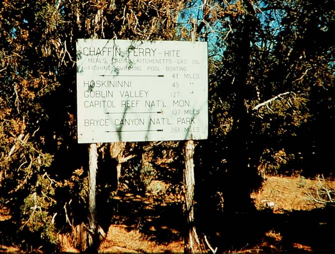
In 1959, the old road leaned to the left, into Farley Canyon and eventually to the ferry.
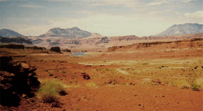
you can still see the lake in the distance.
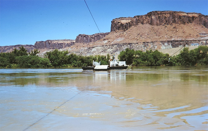
of the Hite Ferry in White Canyon, looking west. 1962
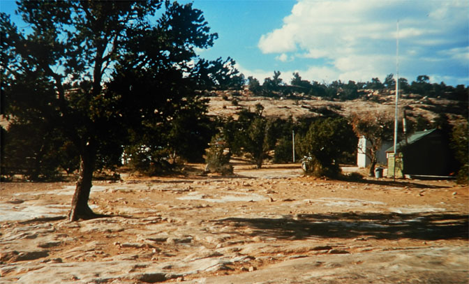
“What Can I See Without Getting Out of my Car?” era.
Photo by Charles Kreischer in 1959
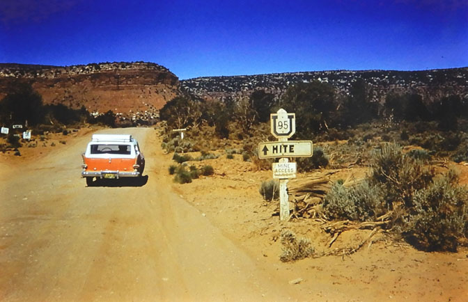
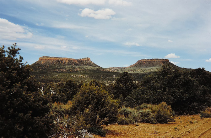
Photo by Charles Kreischer. 1959
NEXT TIME: The Hite Ferry & the White Canyon Store, with images from Edna Fridley and Charlie Kreischer again. A place that no longer exists. Even as the reservoir continues to shrink, the Hite ferry location is most likely buried under a hundred feet of silt. It will take decades or more for the silt to be flushed downstream, and where it goes, once it all makes its way to the dam, is a question future engineers will have to figure out. JS
EDITOR’S NOTE: Keep an eye out for future offerings from Edna Fridley and Charles Kreischer. Their images are like time machines, not just transporting us into the past, but to places that simply don’t exist anymore. Their contribution to history is beyond measure…JS
To comment on this article, scroll to the bottom of the page. Thanks.


Wow, thanks for these. I was just at Hall’s Crossing a few months back–an empty, eerie, freezing place in February with acres of empty asphalt and dozens of empty houseboats and not a soul in sight except for a couple from Kazakhstan–so the pics are particularly resonant.
When, exactly, was 95 paved?
Beyond the Zephyr, which is a wonderful place for these pics to see the light, are there any plans to make these photos part of a publicly accessible collection?
Thank you!
UDOT started “improving” Utah 95 in the early 70s..They had to blast a new route through Comb Ridge and had abandoned the old “dugway” by August 1973. I have photos of the construction near Bears Ears from that month. It was still dirt and gravel for most of the remainder of the route, almost all the way to the lake until 1975, when the rest of the paving began. It’s still designated “The Bicentennial Highway? because the entire road was completed in 1976…JS
Wow! Thanks for great pictures. A question-The old road into Arches, the one Abbey took., can you still get in that way and about how long is until Balanced Rock?
I never got along with my mother. You probably wonder why I would start a comment on this article that way. It’s like this: My father bought a Leica in 1935 and started taking it on trips from his St. Louis home to the Southwest with an old friend. Later after my parents married they continued to travel the SW. After I was a few years old they took me with them. Our second car in the 1950s was a Jeep, at a time when nobody in a midwestern city owned a Jeep. We hit all the Utah and Four Corners sites again and again. My father’s favorite film was Kodachrome 25, which lasts virtually forever without losing color. We had tons of slides and viewed them regularly. One series was on the Hite ferry, when we got hung up on a sandbar and the operator dribbled sand onto the cable wheel propelling the ferry to get it unstuck. That old Model T or whatever it was that powered the ferry alway stuck with me. After my father retired and they moved to Oaxaca the old man’s slide collection disappeared. After he died my mother said she dumped them at some point. Can’t forgive her.
whoa, sorry you wrote that. i’ve been thinkin’ about (not moving as such but) gradually ending up in Oaxaca …
I read this piece and studied these photos with keen interest, and am looking forward to seeing more. It means a lot to me. I worked at Natural Bridges as a seasonal ranger 1970 and 1971, and have been back working there seasonally 2018 since. I will return for a 2-month stint next month (August).
U-95 was a unique highway in transition in 70-71. The new pavement was in as far as Cottonwood Wash (going west from Blanding), then the original dirt road took over from there, through the tortuous Comb Ridge dugway, and on to the Cedar Mesa, where suddenly pavement once again took over for about 10 miles as the “new” highway passed Natural Bridges. Continuing west, it once again reverted to the original dirt almost to Hite where once and for all it finished the run as slick pavement crossing White Canyon, the Colorado and Dirty Devil Rivers on the still new gleaming bridges. I had many an interesting conversation with visitors to the Bridges about that road back in the day.
This last summer we had sort of a redoux of that experience. The Cottonwash Bridge, comparatively a very minor span, was found by the Highway Department to be structurally unsound due to years of erosion. Once again, motorists were relegated to detouring by nearby secondary dirt roads prone to monsoonal washouts or an ascent of the Mokee Dugway, still legendary in its thrills to some, (I understand that the Cottonwood Wash bridge is now back in service).
In the last few years that I have worked at the Bridges, I have diligently acquired to the best of my ability a collection of photos, documents and recollections that better show the history of the Monument and its surroundings, including U-95 and Hite, in those less developed days. I’m still working on it! So if any of you have any wonderful tidbits to share, I’d love to hear from you. I’ll be back at Natural Bridges National Monument starting August 21.
I have no tidbits to share, but I’ll be there in early October, if all goes well, and would love to hear stories.
I tried to apply for a seasonal ranger job in Utah and I’m not “eligible”: only federal employees in certain “hiring paths” are eligible to apply! I guess it’s like the timed entry permit for Toroweap….
Yes, more photos please. Great to see what that area looked like before the dam was finished. I’d like to see what the canyon looked like before it was flooded.
Fascinating pix. Thanks! Brings back memories (at 76, I’m old enough) of when that country still felt like a mysterious primeval wilderness, known to but a few. Fast forward to 2022……and this month, you’re going to need a kind of “timed entry permit” to visit Toroweap. The “blank spots on the map” are diminishing fast.
The magic of unpaved roads. And real roads that are the only route between inhabited places, not just forest tracks.
Back in the day, among my friends we would brag about how much of any given journey we could do on dirt.
‘A new road was built in the late 1960s, miles from here and on the other side of the canyon that reduced the amount of walking required to see all three bridges. It was the beginning of the “What Can I See Without Getting Out of my Car?” era.’
I keep saying we need to promote the next stage of industrial tourism: “What Can I See Without Leaving My Apartment?” Maybe the metaverse will save what’s left of the West.
Thanks for sharing these pictures – I look forward to seeing what else you have stashed away !
The ‘before and after’ photos of the Kreischers decending into Farley are particularly striking.
Using modern technology, I’ve managed to nail some of the locations in these images. Mountains don’t move and the old ‘Highway’ seems to follow the same route it did 60 years ago.
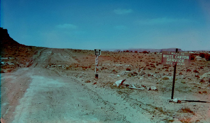
Picture 12, captioned “Another photo by Edna Fridley. I believe this is actually east
of the Hite Ferry in White Canyon, looking west. 1962” is slightly puzzling.
I agree with you that Edna’s photograph was probably taken in White but I’m fairly certain her camera was pointed NNE. I suggest this picture was taken close to where Highway 95 crossed the wash in White Canyon.
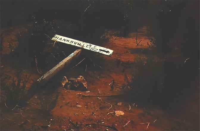
“13 miles to White Canyon service” would be about right from crossing the wash, heading up the west side of White and then turning east to descend into Farley and on to the ‘town’ of White Canyon.
Am I allowed to say Google Earth? Some guy last year ran a camera up the modern route, or possibly the same route, of the old Highway 95 on the west side of White.
Some of the frames are tantalizingly close to a match with Edna’s 1962 photograph. Unmade ‘roads’ near washes probably change routes over time but this is the closest match I’ve found:
37.800277N,110.374206W Go to the blue line StreetView, jiggle a bit, zoom in, move forwards or backwards etc …
* Er … west into Farley, obviously. It’s easy to lose your bearings.
cool pictures; thanks for sharing these. Ever see those Sherwin-Williams paint trucks with the logo “Cover The Earth”? thank God they haven’t yet….
Righto. My final, definitive, thoughts on Picture 12 where Edna Friedley is 13 miles from White Canyon Service:
That photograph was taken at 37.764512N,110.285041W, give or take a few inches either way, and her camera was pointed pretty much due North.
The wash just ahead that crosses Old 95 from left to right is approximately 30 yards from where she is stood. It drains into White Canyon proper roughly 500 yards to the SE of where Edna took the shot.
Where Old 95 crests the ridge is approximately a third of a mile from the camera. Yeah, appearances can be deceptive !
New 95 follows the same line as Old 95 in this area. The constructors moved a whole lot of earth to create an embankment which allows this wash and others to flow underneath.
Edna’s 1962 photo looks a little ‘up and downy’ but the New 95 has a steady gradient up to the crest.
If you do punch in those coordinates and wonder why you are seeing ‘extra stuff’ on the horizon it’s because the road is higher than it used to be and the camera was on a pole.
Next …
P.S. If you go to the coordinates above, jump onto Street View, zoom in until you have the notch in the cliff on the left and the toe of the white rock centre right both just in view you’ll see the match. It’s a little grainy when zoomed in but the features in the distance are unmistakable.
There is a gentle arc of three distinct white rock features to the right of the ’13 miles’ sign. When you have these alligned as in the 1962 photograph you are in the right place.
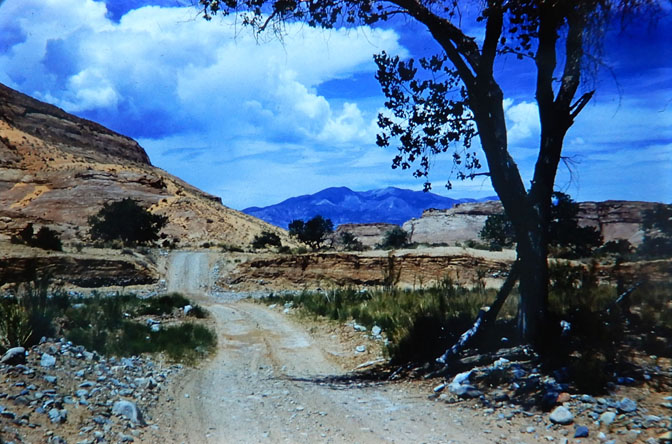
“Descending into North Wash; now the road …” was taken close to 37.973130,-110.491930
That’s approximately 6 miles up from where modern 95 departs the route of old 95.
The modern 95 runs on the other side of the wash; it seems they excavated a channel for the water and used that material to raise the level for the highway.
Again, if you jump onto Google Earth/Street View, all the features are as they were sixty years ago including the faint trace of old 95 winding its tortuous route to the river.
Picture 13, “White Canyon and Utah Hwy 95 by Edna Fridley. 1962.”
I’m fairly certain this was taken on the left (east) bank of the Colorado in Glen Canyon roughly 1.5 miles upstream from the White Canyon airstrip.
The, unmistakable, features at the mouth of North Wash can be seen in the middle distance and are, again, approximately 1.5 miles from Edna’s camera.
This dead-end track branched away from 95 close to where the wash in Farley made its final traverse of the ‘highway’ and followed the river in a northerly direction.
The track serviced the airstrip and several dwellings beyond but ultimately petered out where the cliffs reached the banks of the river.
If anyone is interested, I think this photograph was taken close to 37.844550,-110.416223
Edit: Er, obviously the features at the mouth of North Wash ARE mistakable because they are, in fact, tucked away just out of sight to the left of this photograph.
Straight ahead and some 3.5 miles distant is the mouth of the Dirty Devil. The butte just right of centre is 0.75 miles from the confluence of the Colorado and Dirty Devil and, therefore, over 4 miles from the camera. It is a stand-alone feature and not, as it appears, part of the cliffs extending to the right. The modern highway runs behind it.
Slightly to the left of centre you can just about make out the rock stack on the northern side of Glen Cove that modern 95 cuts behind on its way to North Wash.
To summarise: Looking almost due north, Edna took this picture from the left bank of the Colorado a little over 2 miles north of the ‘town’ of White Canyon. According to period maps, this track ran north from Hwy 95 at Farley Canyon until the topography defeated it. The, now defunct, Hite marina is a couple of miles further up on the right.
I remember a family road trip across the recently completed “Bicentennial Highway” in yes, 1976 at the age of nine. Every time I’ve traversed it over the last 30 years I’ve wished it was still dirt!
Thanks so much for this special history. You are officially a historian!!! Much appreciated!!