
With Photographs courtesy Tom McCourt except where noted…..
With my new camera, I had one roll of black and white film – twelve exposures. That single roll of film was my only chance to capture the image and the essence of Glen Canyon before Lake Powell swallowed it up. I knew it was a daunting task, and I wished I had better equipment and a bucket full of film, but I had to make do with what I had. I spent each frame as dearly as I knew how.
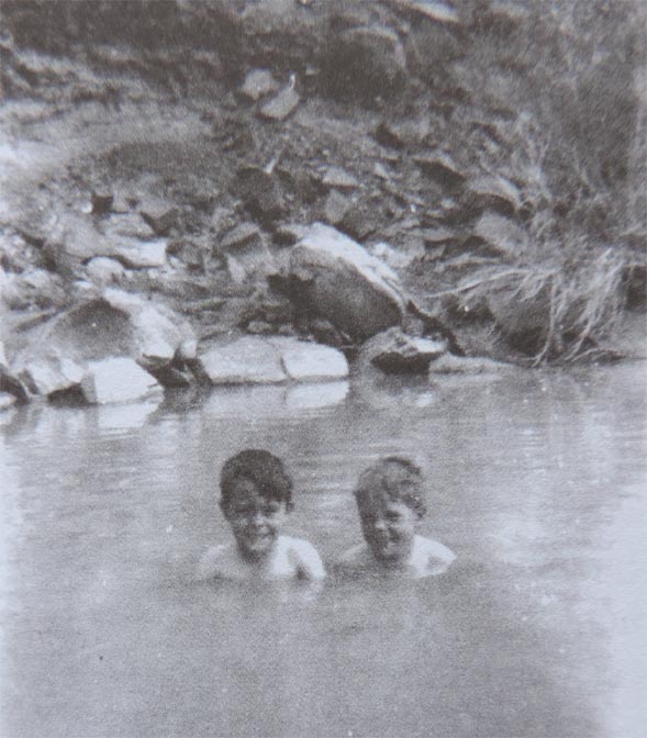
My last trip to White Canyon was in December 1959. It was just a few days after my thirteenth birthday. Grandpa was going to the desert again to do assessment work on his uranium claims, and he asked if Reed and I would like to go along. I was thrilled. I had been given a little box camera for my birthday, and I was excited by the opportunity to take some pictures before Lake Powell covered my favorite place forever.
Before we even started, I had a feeling about that trip; a premonition I suppose. Somehow I knew that this would be my last visit to that special place of my childhood. I was going to White Canyon to say goodbye.
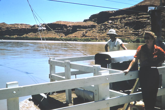
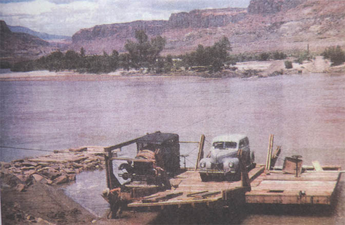
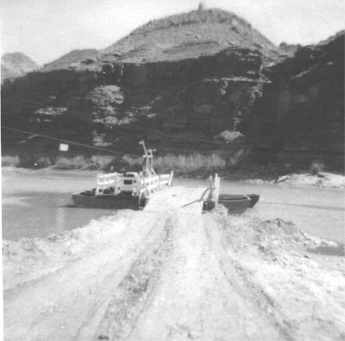
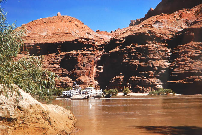
… The Hite ferry was still just as I remembered it. Grandpa stopped at the house to visit with the ferryboat operator and his wife. They were delighted to have company at their lonely duty station. I excused myself and walked over to where the ferryboat was moored. I took the first of my twelve precious pictures.
While Grandpa drank coffee and visited with the ferryboat people, Reed and I climbed a rocky hill above the ferry site. We found some good petroglyph panels (Indian writings to Grandpa) incised into the sandstone. One panel was a row of five handsome warriors with what appeared to be feathers protruding from their heads. The panel was carved on a low rock wall, but hidden behind some large boulders. The warriors were hiding there out of sight like a war party waiting to ambush the stagecoach. With some distress, I looked at the big river nearby and knew that the dark water would soon find their hiding place. I wanted to save those handsome warriors, and so I carefully took another of my twelve pictures.
And then, as we got closer to the crest of the hill, we found the signature of old Cass Hite himself. The inscription was fairly large and in an antique cursive style. It was on a discrete rock face and not visible until a person stood right in front of it. It was chiseled into the everlasting stone with a bold hand … Cass Hite 1883.
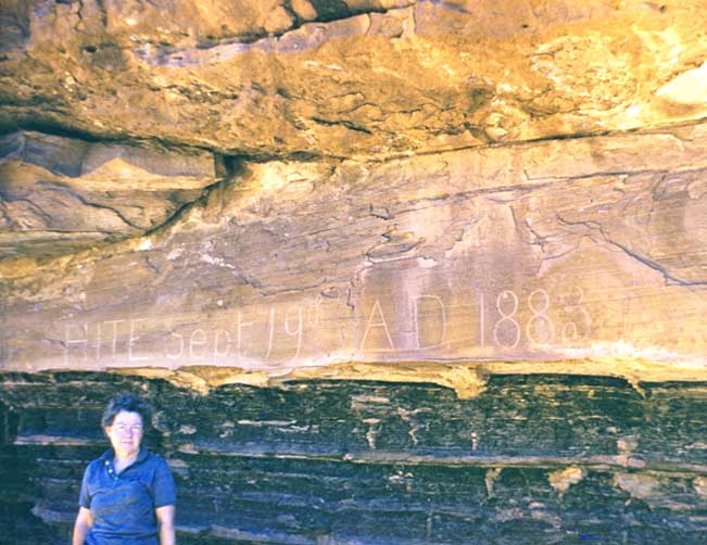
From the inscription, we could look down on the farm, the ferryboat landing, and the entire little corner of wilderness that Cass Hite had claimed as his own. I held the little camera in my hands and agonized about taking a picture of the inscription. I only had nine frames left, and we weren’t even on the White Canyon side of the river yet. I decided to save the film and take pictures of more interesting things later on.
I don’t know if the ferryboat people ever saw the inscription, or if anyone ever recorded the site before the water covered it. Today, that bold pioneer signature lies in the mud at the bottom of the lake, and what I wouldn’t give to have that picture now.
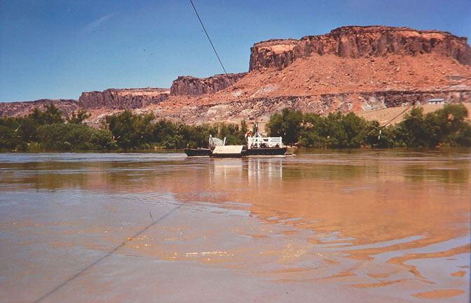
We crossed the river on the ferryboat. The water was low and the ferry cables hung high overhead. We left the boat and drove the short distance to the old town site.
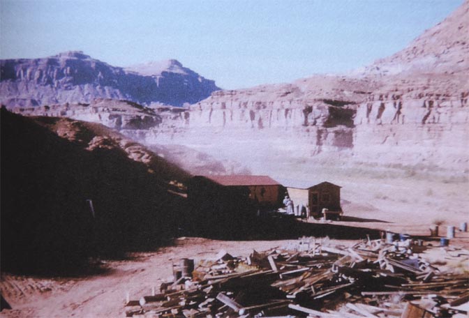
I knew the town was gone. But I was not prepared for what I saw that winter’s day. Not only was the town gone, but her very foundations had been plowed under. Only the purple-gray tailings pile remained where the mill, the company buildings, and the boarding house had stood. Across the White Canyon wash, the store was gone, and so were all of the other buildings. The bare ground had been scraped and bladed smooth and even the weeds and bushes were gone. Only the schoolhouse remained, alone and empty. It was the gutted shell of a once-happy building, echoing the wind, and full of drifting red dirt and the tracks of vermin.
The ground was scarred with old truck and bulldozer tracks preserved in frozen mud. The refuse and rubble of a once thriving little community had been pushed into piles and burned. There were several large, black, burned spots on the ground where odd pieces of wire and metal reached up from the ashes like the limbs of dead and dying creatures.
The town site was eerily quiet, and for the first time in the canyon, I noticed that when we slammed the door of the pickup truck we could hear the echo in the ledges.
Grandma’s house was still there, filled with dust, cobwebs, and packrat poop. It had been standing alone in the desert for over three years by then. The two houses were vacant shells, empty of furniture and warmth. Our voices echoed in the bare rooms in the same way the truck door echoed in the ledges. The feel and the love of my grandmother wasn’t there anymore, and without her the place was only a shed on the cold desert floor. The buildings were so empty and depressing that I didn’t even take a picture of them – a decision I have since regretted. We camped in the yard and slept in the back of the pickup truck.
The second day we were there … We climbed up to the old Indian fort that guarded the river canyon – good old Fort Moki. She watched us climb the hill to her, and she was happy to see us again. She didn’t get many visits from little boys anymore.
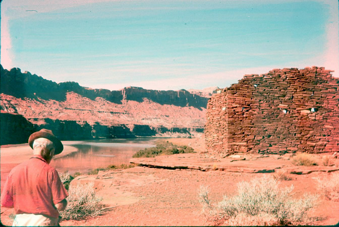
That dark, winter day was our final chance to say goodbye to the Garden of Eden of our youth. It was quiet there that day, and we had the fort and the river valley all to ourselves.
Our voices echoed from inside the ruin, and we stood on that crumpled north wall and looked out over the valley for a long time.
The reality of the Glen Canyon Dam hung heavy like a dark cloud on the southern horizon. There was a feeling of sadness in the air that day, a hurtful knowing that the ruin, the valley, and the river, would soon be gone.
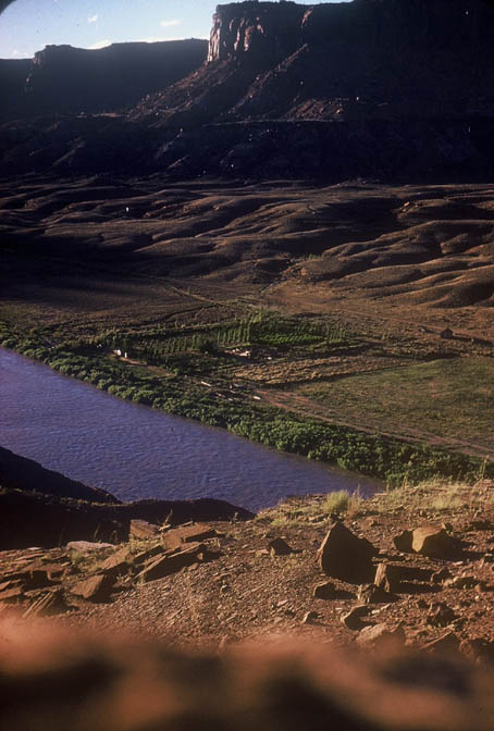
Things were very different from what we remembered as little boys. We were looking down on emptiness. The mill was gone, the town was gone, and there were no shadows of cotton ball clouds in the valley. The day was cold, quiet, and nothing moved. Even the sun didn’t shine.
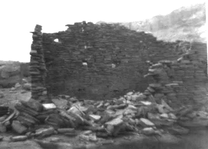
The ruined fort had a strange feeling of emptiness about it too. It was the same feeling Grandma’s house had held, and I was amazed. At other times the ruin had been warm and friendly and the feel of the Anasazi had been very close and personal. Strangely, on that dark winter’s day, the old fort was an empty shell, an open stone box on a hill. The Anasazi didn’t live there anymore.
Grandpa had told us that the water would be deep enough to cover the fort, but I could scarcely bring myself to believe it. The fort was high in the air, far above the river channel. I looked out over that river valley and could not imagine water being that deep. I tried to visualize what the canyon would look like covered with water, but my imagination failed me. My mind rebelled at the thought, and refused to form the image.
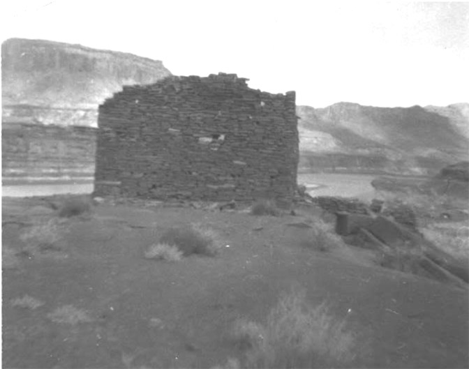
I had nine frames left in my little box camera and I willingly spent at least four of them on the old Indian fort. I photographed her from different angles, trying to get her good side and preserve a portrait for the ages. She was wonderfully photogenic, but my equipment was crude, the light was bad, and my fingers trembled.
I took another of my photographs while standing on the crumpled north wall of the fort. I aimed my little camera up the valley, over the empty spot where the town had been, and toward where a long, thin shaft of sunlight spilled down through the clouds and fell across the red hills near where Grandma’s empty house still stood.
It broke my heart when we finally said goodbye to that magnificent ruin and started down the steep hill toward the canyon bottom. I felt like a traitor. I was walking away and leaving her to her fate, just as the Anasazi had done so many years before.
As we descended the rocky slope below the ruin, the ground was covered with fragments of the most magnificent of Anasazi pottery, and the ragged shards begged and reached up to me. I went from piece to piece, lifting them reverently from the dirt and wiping away the dust of centuries. Each fragment was a treasure, and each treasure a story all by itself. I marveled at the beauty, the symmetry of design, and the brilliant hues of the colors after so many long years in the dirt. Each fragment was a precious, parting gift from the Anasazi, a ceramic teardrop from the very heart of native culture. They were precious pearls to me, and I wanted to save every one.
Like tiny starfish, stranded and doomed on the shores of the sea, I wish I could have saved them all. I filled my pockets and my hat, desperate to rescue as many as I could. It was an impossible task. There were just too many, and I was so small. I tried anyway, knowing it was hopeless, and my heart hurt.
The next morning we started for home. The day was much warmer and we shed our winter jackets. We crossed the river on the ferryboat and stopped to visit with the ferryboat people again.
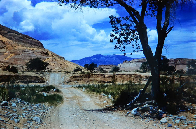
When we finally left Hite for that last time, Grandpa stopped for a while near the mouth of North Wash. He said he wanted to show us something. He pulled the truck off the road and into the scattered tamarisk bushes near a flat place by the river. We walked through the tamarisks a short distance to where an old rock chimney towered high above the willows. Around the chimney were scattered a few old planks, rusted barrel hoops, tin cans, broken slivers of purple glass, and other odd bits of trash. The junk was sinking into the weeds and dirt. There were a few notched and decaying cottonwood logs strewn about, remnants of the log house that had once been wrapped around the chimney.
Grandpa took us toward the river, through the tamaracks, to where a great, cedar post was planted firm in the willows. It was almost hidden by the thick tangle of bushes, and Grandpa had to search for a few minutes to find it. The post was bleached from years in the sun, and the uncaring tamarisks had crowded right up against it. When he finally found it, he pointed out where scars and rope burns dug deep into the wood. The heavy post stood just back from the river on a sandy bar that held it slightly elevated above the level of the river floods.
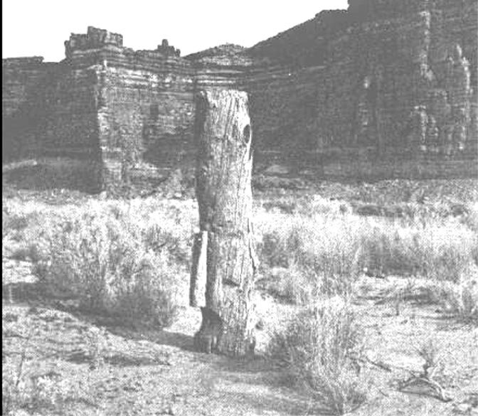
Grandpa stood near the post and pointed at the river. “This is the Dandy Crossing of the Colorado,” he said with an air of absolute conviction. “People think it was down at the ferry site, but it wasn’t.”
He then pointed out some features of the river. “Can you see how the river makes a bend here?” he asked. “The current changes sides here, twice. We are standing in the middle of the bend. The current is right up against the shore here at our feet. If you get in the water here, the current will take you across the river to the other side. If you are on the other side of the river, all you do is go upstream a little ways and the current is at your feet over there. If you get in the river there, the current brings you right here to where we are standing.”
It was so obvious.
He continued: “This post was a brace to help pull wagons or rafts up out of the river. … A horse was used to pull a rope against this cedar brace. That’s why the rope cut so deep into the wood.”
He pointed at the river again. “Right here is where the Indians and the early pioneers crossed the river. This is Cass Hite’s Dandy Crossing of the Colorado.”
He stood and looked at the river for a long time, as if watching it all happen. I looked at the river too, and while I stood there, painted Indians on beautiful horses, Spanish Conquistadors, cowboys and covered wagons, all swam the river at my feet.
The Dandy Crossing of the Colorado was almost due west of the present site of the Hite Marina and near the mouth of North Wash. It was a little south (downstream) from the base of that towering butte where John Wesley Powell camped and Jack Hillers photographed in 1872. It was at the site of the hardscrabble gold camp called “Crescent City” that Robert Stanton photographed in 1889.
As we started up North Wash on the way home, we boys started pestering grandpa to stop at Hog Spring and say hello to the Moki Queen [pictograph] again. It just didn’t seem right to drive past that Indian Princess without stopping to pay our proper respects.
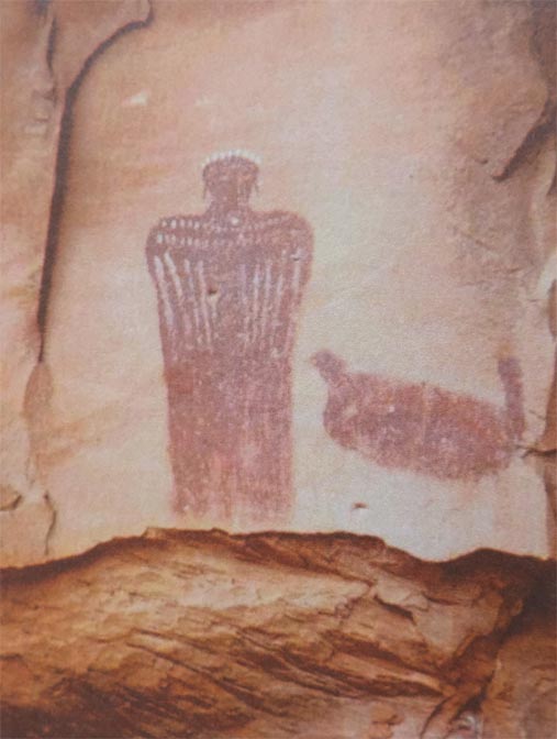
When we got to Hog Spring, there was a man and a woman camped there, which surprised us. I couldn’t remember other people ever camping there. I thought Hog Spring was our secret, private place, and I was annoyed by the intrusion.
The people were strangers, and they looked out-of-place on the desert. They were probably in their late twenties or early thirties, and they were driving a silly little car out there in the rocks and gravel where everyone who knew better drove a pickup truck. The little car had an ugly gypsy rack on top that was bulging with suitcases, gas cans and camping gear. There was a canvas tarp spread on the ground near the little car, and on it were a thin cotton mattress, several blankets, pillows, and clothes.
The people were dressed like foreigners. He was wearing a stupid fedora type hat, dress pants (slacks), and a silky, short-sleeved shirt. He was also wearing low cut city shoes out there in the sand, and that made me smile. She was decked out in tiger-striped pedal-pusher pants, a short-sleeved blouse with the tails tied in a knot around her middle, and slippers. Her hair was tied up in a red bandana and she looked like Lucille Ball doing a comedy sketch.
We got out of the truck and said hello to them politely and cautiously. I’m sure we were staring way too much at their improbable clothes, transportation, and camp outfit. Grandpa made polite small talk for a few minutes and then he noticed the fresh yellow paint on the ledge beyond the spring. He stood with his mouth open for a moment, and then he pointed and asked, “Did you do that?”
The man was stupid, and he nodded innocently, allowing that yes, he had done that. I followed the direction of my Grandpa’s finger and the yellow paint screamed at me when I saw it. There … on that sacred, dark brown sandstone ledge was a gaudy billboard:
Milo and Vivian
San Francisco California 1959
Grandpa came uncorked. I knew he was a scrapper, but I had never seen him with blood in his eye. He was probably thirty years older than Milo, but he stepped right up to the dim-bulbed San Franciscan and stuck his chin out as if daring the man to take his best shot. I don’t remember all that was said, but I remember how he said it, and I thought Grandpa restrained his language admirably; after all, the man’s wife was present. Suffice it to say that Milo knew right away that he had made a big mistake. Grandpa told the man that North Wash was our back yard and he didn’t want to see old Milo’s name every time he came down that road. He told Milo that he didn’t give a damn who he was or where he came from.
Grandpa was fuming and Milo looked like he was going to be sick. But Milo might have been smarter than I knew. He wisely didn’t say anything and just stood there stupidly with his mouth open. I thought for a moment that Vivian was going to abandon old Milo to his fate and flee into the ledges like a prairie chicken. She stood with both hands over her mouth, eyes wide in panic. We didn’t stay long at the Moki Queen that afternoon. In fact, we didn’t even get to visit with her. Grandpa was upset and anxious to be gone and we were soon headed for Hanksville. Grandpa held the steering wheel in both hands and puffed on his smoke like Popeye The Sailorman. He said it was a good thing we didn’t show Milo and Vivian where the Moki Queen was anyway. The sorry (expletives deleted) would have probably painted it over.
As we left, Milo and Vivian were breaking camp and hurrying to be gone. Vivian was dumping armloads of camp gear into the back of the little car like she was taking out the trash. Milo was on his knees, rolling up the bedding and pretending that he still had the strength to walk, if he really wanted to.
They were the first real tourists I ever encountered on my red desert, and they were the spearhead of an invasion
*****
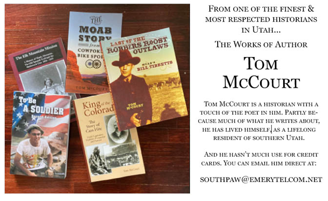
Tom McCourt is a native son of the canyons and deserts of Southeast Utah. Before Lake Powell flooded Glen Canyon, he spent a portion of his childhood at Dandy Crossing, playing cowboys and Indians amid the ruins of Cass Hite’s old log cabin. Tom has written four other books about the people and places of Southeast Utah. He is a graduate of the University of Utah and served proudly as an officer and a gentleman in the United States Army.
To read ZEPHYR chapters from Tom’s remarkable book “Last of the Robber’s Roost Cowboys: MOAB’S BILL TIBBETTS,”
POSTSCRIPT by Jim Stiles:
In 2005, the Powell Reservoir’s water level dropped to record lows. For the first time such iconic treasures, like Cathedral in the Desert emerged briefly from the lake. A couple years later, record snow packs raised the lake again to within fifty feet of maximum pool levels. Tom McCourt wondered if perhaps the old Fort Moki had emerged as well. To his surprise, he found the remnants of the fort. Its walls had mostly collapsed after 40 years under water but all the rocks were still there.
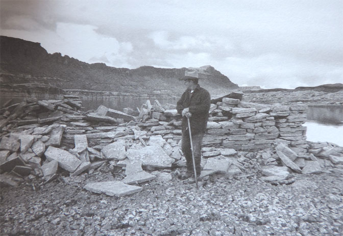
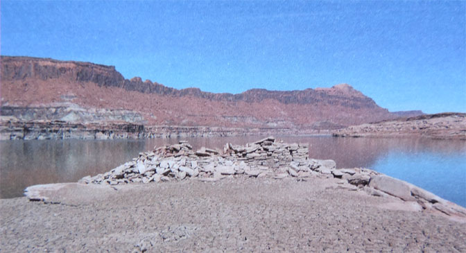
As noted, the reservoir rose again, peaking in 2017. But as many expected, the prolonged drought drew the reservoir down again, to levels even lower than 2005. Tom went back to one of his favorite places on earth, to his beloved Fort Moki. But there was no sign of it. He realized that while the water level was down, the river and its side canyons had continued to carry the heavy silt, for which the Colorado River is named, into the main channel. Now, Fort Moki was no longer submerged; it was buried under tons of sediment.
Eventually, more floods and the passage of time, may expose Fort Moki once more to the world. But it may be a very long wait…JS
BONUS: ADDITIONAL IMAGES by CHARLES KREISCHER, BETH NIELSEN & EDNA FRIDLEY
TO COMMENT ON TOM McCOURT’S STORY,
PLEASE SCROLL TO THE BOTTOM OF THIS PAGE.


And I encourage you to “like” & “share” individual posts.
Why they can’t just leave the site alone is beyond me,
but that’s what Facebook likes to do.
ALSO NOTE: I post old photographs and stories from our 25 year old archives every day. Pictures from Herb Ringer, Edna Fridley, Charles Kreischer.. even a few old photos from my Dad. So if you want to stay caught up on our historic photo collections,
be sure to “follow” us on Facebook…Thanks…Jim
https://www.facebook.com/FansoftheCanyonCountryZephyr/
https://www.facebook.com/FansoftheCanyonCountryZephyr/


https://www.facebook.com/profile.php?id=100086441524150


And check out this post about Mazza & our friend Ali Sabbah,
and the greatest of culinary honors:
https://www.saltlakemagazine.com/mazza-salt-lake-city/

More than six years ago, The Zephyr, me & four other individuals were sued for defamation by the former Moab City Manager. Faced with mounting legal bills, my dear friends John and Isabel De Puy donated one of John’s paintings to be auctioned.
ALL the proceeds went to our defense.
Thanks to them, our bills were almost completely covered.
Now I’d like to return the favor. Check out the link below and their online shop… JS
https://www.depuygallery.com/shop.html


And once more, now that you’ve read the latest Zephyr Extra and waded through the ads, please take a minute to comment. Thanks for your support…. Jim Stiles
What a major shame! Such a shocking trip for the McCourts! Imagine even in those early years that ignorant people would use yellow paint in such a beautiful unmarked area!! But the photos are invaluable, showing the history that would otherwise be lost. Thanks again for doing your part to save it!
Zephyr readers,
I just got an email from the author of this story, Tom McCourt. Ge notes that there are two corrections in it, that are fixed in the Second Edition (which is out there right now)—Anyway take note of Tom’s comments below…JS
The Cass Hite inscription on Beth Neilson’s photo was down by the road near the Hite farm. The one my brother Reed and I found was up on the hill above the road and could not be seen from the bottom of the canyon. The one we found was in cursive writing, like a signature. I was hoping that with the water level of the lake as low as today the signature could be found again, but unfortunately, the mud is over 100 feet deep there now and I’m sure the inscription is lost, to our generation, at least. Perhaps some serious erosion over the next 50 or 100 years might reveal it again.
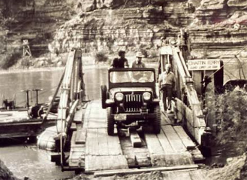
In the second edition of the book, I tell that my grandfather was wrong in his assessment of the location of the Hite Ferry. That ferry post at the mouth of North Wash was a part of the old Harshberger Ferry, put there by a copper mining company around 1900. I got that information from James Knipmeyer. Also, Pearl Baker said in some of her writings that some old timers told her the Hite Ferry was located right where the Chaffin Ferry was located in the late 1940s that endured until the lake backed up.
—Tom McCourt
Hi, Jim. I had my doubts about Grandad’s Dandy Crossing theory.
There were convenient sandbars at the mouths of both North Wash and White Canyon but the terrain down at the, eventual, site of Chaffin’s ferry was far more favourable on both banks of the river.
Loved reading Tom’s recollections of his last visit to Paradise.
As always Jim, a gem of a story. The pictures are pure gold.
ditto to what W M wrote. like many/most Zeph stories, this is/was a meditation unto itself. makes it feel like you’re there ~
Thanks Rosco. Like you, I think Tom is one of Utah’s best historians. He goes far beyond “just the facts.” He brings it to life. In this story it’s a personal journey. But read his book about Bill Tibbetts. He let us repost the book, a chapter at a time, in The Zephyr a few years ago.
Thanks for sharing this with us Jim. I hope you are doing well.
Thanks Shannon.
great story–I wonder if the yellow paint survived Lake Powell! Ha! Take that, Milo & Vivian…
The yellow paint was scrubbed from the ledge in the early 1960s when the Utah highway department improved the road down North Wash to accommodate the soon to be expected Lake Powell traffic. There is now a picnic pavilion and restrooms at the old Hog Springs camping site. And, North Wash is still one of the most scenic roads in all of Utah, and most people don’t know it because it hasn’t been advertised as such. Tom McCourt
Here’s a question: how would our sense of loss and nostalgia differ if humans lived significantly older (or shorter) life spans? Would what we now consider dramatic changes in the landscape seem more like recurring ephemeral phenomena? And of little consequence?
If we lived for 1000 years, then we would all witness, say, multiple “catastrophic” wild fires, and also witness the ecosystem recovery that might take a century or two. Would that change our appreciation for the role that fire plays in nature–and the risk it poses if we build in the wrong place?
If we lived for 10,000 years then we could start to appreciate things like mega-climate changes, though to witness even one typical glacial-interglacial cycle we would need to live at least 10 times longer than that.
So I guess while I might mourn the loss of Glen Canyon, I know it is temporary, and a loss only judged by my own timeline.
Wise words, Bob. You’re absolutely right. I rarely if ever engage in environmental politics these days. While I can’t help but grieve for “these things lost,” I’ve also tried to look at life through the lens of geologic time. I still remember a page from “On the Loose,” by Terry and Renny Russell. On one page was a Philip Hyde image of the recently drowned Glen Canyon. On the opposing page was a simple caption. It said:
“Was it always like this?”
“Most of the time, yeah. But for a while the river didn’t flow.”
He shook his antlers and went back to browsing.’
I recite that from memory. I may have paraphrased a bit, but the message is clear, as you just reminded us. Thanks.
This is so very sad. The cost “progress” need not be so high.
Apparently, I have to be the bearer of bad news regarding the fate of the archaeological ruin called “Fort Moki” here in this article (aka “Fort Moqui” or “the White Canyon Ruin”.) In October of 2021, Tom Martin led a photo-rematching survey on today’s Colorado River between North Wash and Bullfrog. The presentation can be viewed at https://vimeo.com/638086686. Start viewing at approximately 4 minutes 50 seconds and continue through 9:00.
Because the Colorado River is now roughly 120 feet above its historic river channel, now running through relatively soft sediment deposited by Lake Powell, the river frequently changes its course as it finds its way back downwards. At some point between 2005 and 2021, the ancient ruin found itself right in the river current and was swept away.
(The first reconstructed image at 4:50 showing the view downstream from the “Fort” location hits you like a punch to the gut when you comprehend the magnitude of sediment deposited by Glen Canyon Dam in the Hite area.)
Thanks for the link to the Tom Martin presentation. Fascinating and depressing in equal measures.
The perfect storm that finally did for Fort Moki may have occured relatively recently. For those stones to be swept away required a) a low reservoir level b) a massively elevated river and c) obviously, the river had to be flowing over the site.
From what I can tell, the Fort was sat on its rocky perch at an elevation of ~3560, the historic elevation of the Colorado being ~3445 at that point. Scary stuff.
From the historic satellite pictures it appears that conditions a), b) and c) were first met in April 2016 when a fully-charged Colorado flowed directly over the site of Moki. This condition had existed for a few months but by April the channel across the Moki site was taking the full flow of the river. This is probably when the fort was washed away. By May 2016 the reservoir was back up again and the force of the Colorado had shifted north a half-mile.
The next time the river reverted to that channel was towards the end of 2018. Even more sediment had been deposited at the mouth of White Canyon, forcing the Colorado into the lower reaches of White before turning back on itself and flowing over the site of Moki. This is the period when sediment began to be banked up on that tight turn at the mouth of White.
The reservoir rose and fell again. By March 2021 the Colorado had carved through the crud on a course closer to its historical route. Moki was definitely long gone by this time. The lake in White Canyon was completely isolated from the river by the mound of sediment at its mouth. It would take until 8th June 2023 for Powell reservoir to breach the sediment bank and reclaim White Canyon.
Lake Farley still exists in splendid isolation. The piles of sediment at its mouth must top out above the 3585 mark for it to have avoided inundation this time. It evaporates water but is still ~80 feet deep two-thirds up from the mouth. Current surface elevation is somewhere around the 3580 mark, so only 7 or 8 feet above the reservoir level but before this year’s heavy runoff was probably 20, or more, feet above the level of the mothership.
Now, what was I doing?
Thanks indeed Bob, so our once proud ruin, reduced to a few surviving rows of stones at its base after about 40 years under water, spends its last decade (say about 1% of its life) alternately presiding over and being re-submerged by a mud flat completely burying the huge canyon it overlooked for about a thousand years, before being washed away for good. Yeah, we’ve got this preservation thing down I think…
Yeah, Doug. Try to focus on the positives though … Er, um, hmm …
Nope, me neither.
K-den, I was late to reading and commenting because I’ve been on the Rez aka land of spotty internet. So, my comment is, everything every one already said about this priceless history brought to us by the Z.
Man, this all the news that causes fits. No need to rush here.
What is also striking about Tom McCourt’s pictures of the remains of Fort Moki in early 2005 is that, at 3555, the reservoir isn’t showing any signs of the dreaded Dominy sediment build-up. Essentially, these pictures show a reservoir that has simply dropped to 145 feet below its maximum level. Clear blue water in every direction, from White to Trachyte and beyond. Appearances can be deceptive though.
For 20 years, 1980-2000, the Colorado had been quietly dumping its load into the upper reaches of Powell reservoir at elevations between 3670 and 3707. Every time the reservoir dropped, the sediment would be flushed further downstream. Still, in 1999, with Powell close to Full Pool, nobody boating at Hite Marina would have noticed the ground rising beneath them. (Actually, I think the marina was already closed by then).
Then the drought begins. The reservoir drops 140 feet between late 1999 and early 2005. Five years from being near Full Pool to Tom McCourt being able to access his beloved Fort Moki on foot. It was slightly crumpled after decades under water but not entirely beaten. 140 feet of still water over a thousand year-old structure was never going to erase this proud monument forever, right?
For the last 18 years the reservoir has come and gone in the White Canyon area. Early 2023 the Colorado met the flat water of Powell somewhere around the bend at The Horn. The deposition of sediment is constant. Wherever the interface between the reservoir and river happens to be is where the Colorado dumps its load. This interface, for many years, was in the region of Farley and White canyons.
I’ve now forgotten what I was trying to say.
Oh, yeah. Tom McCourt 2005, no visible sediment at reservoir elevation 3555.
Sediment as far as the eye can see in 2023 with the water in Farley Canyon blocked-in by a mound that rises well above 3585. All this change in the space of 18 years.