
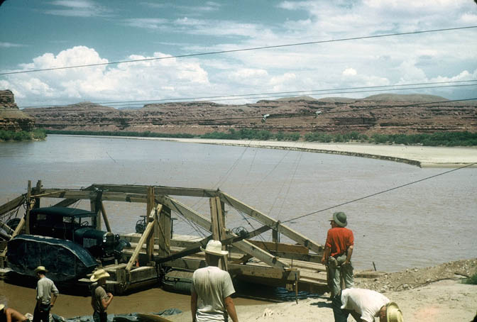
For centuries, for thousands of years, humans struggled to find a way to cross what would someday be called The Colorado River. Sometimes a shallow part of the river provided such a crossing. Called “fords,’ critters of all types, including the ones who walked upright, could make their way across the river, when the water flow was low. One such ford would come to be known as Hite Crossing, named after the man who discovered the ford, Cass Hite. For decades men dreamed of building a bridge ir a ferry across the river. Such a project would connect the western and eastern sides of the state. Even after World War II, southeast Utah was one of the most remote and difficult to navigate parts of the Lower 48. But all that finally changed. In his excellent account of “The Event.” Zephyr contributor Barry Scholl described it like this:
“In the annals of southern Utah history, September 17, 1946 was a day to be remembered. With proper pomp and circumstance—even the San Juan County High School Band—the Hite Ferry was dedicated. With the completion of the ferry it was now possible to travel by automobile all the way from Hanksville, across the Colorado River to White Canyon and onward to Blanding. The opening of Arth Chaffin’s homemade ferry represented the first vehicle crossing between Greenriver, Utah (for years, the name was generally written as a single word) and Lee’s Ferry, Arizona.
“Pioneer riverman Harry Aleson was the first speaker of the day. Before a crowd of 400, including Bishop E.P Pectol of Torrey, southeastern Utah pioneer Zeke Johnson, Utah State Roads Commissioner K.C. Wright, and Utah Governor Herbert Maw, Aleson described the effort that had gone into making the ceremony possible.
“For years Arthur Chaffin’s ranch was unquestionably the most isolated in the United States. He lived 120 miles from the nearest railroad and his nearest neighbor downstream on the Colorado was at Lee’s Ferry, 162 miles distant. The next neighbor on the river was the Bright Angel Trail, 251 miles away in the bottom of the Grand Canyon. His third nearest neighbor was my father’s son, who lived at MY HOME, Arizona, 442 miles away in the bottom of the mile-deep Grand Canyon.
“Arthur Chaffin’s ranch is still isolated—it is 70 miles from the nearest community—but today automobiles can reach the region, cross the river on the ferry, and continue on through Utah’s most colorful and primeval region, thanks to Governor Herbert B. Maw and the Utah State Department of Publicity.”
“Hard as it is to believe today, only 50 years ago one-tenth of Utah was cut off from automobile traffic, a region of scenic wonders known to only a few prospectors, adventurers and cattlemen. After years of what historian/journalist Barbara Ekker described as “construction work, sleepless nights, borrowed equipment, begged funds and sheer hard work,” Chaffin managed to almost single-handedly improve the road from Hanksville down North Wash to Glen Canyon, thereby opening the area to vehicles and tourists.”
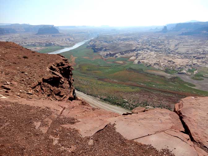
But the “real world” was bound to catch up with Southeast Utah eventually. For the next 25 years, the gravel and dirt road from Blanding to Hanksville, with the ferry connecting the east and west sides of the Colorado, changed very little. In the 1950s, with the uranium boom in fill swing, major discoveries in and near White Canyon necessitated a better way to cross over the 2000 foot escarpment of Comb Ridge. A narrow one lane road was built by the Utah Department of Transportation and called it the “Comb Ridge dugway.” It was a scary ride, especially for the ore trucks, but most of them survived. Proof that some didn’t lies in the rusted remains of old trucks that can still be seen at the bottom of the canyon.
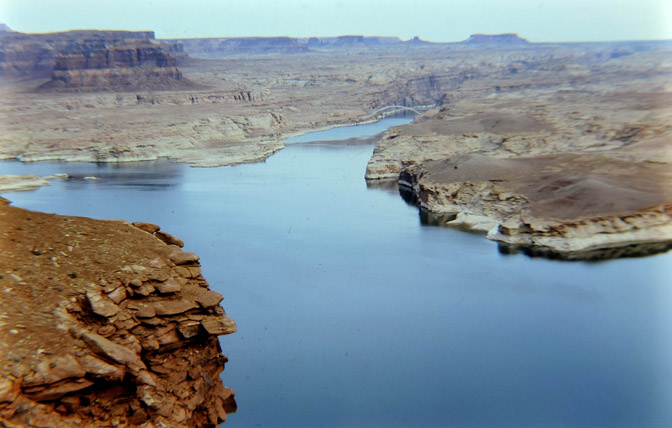
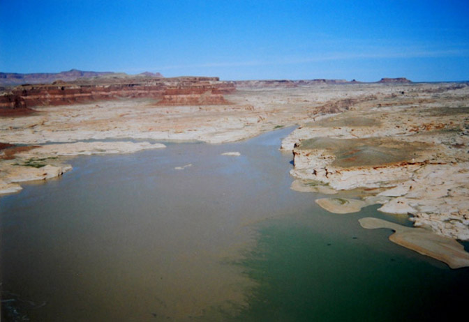
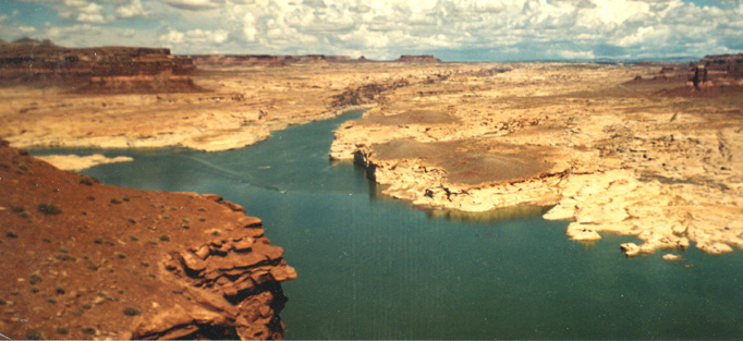
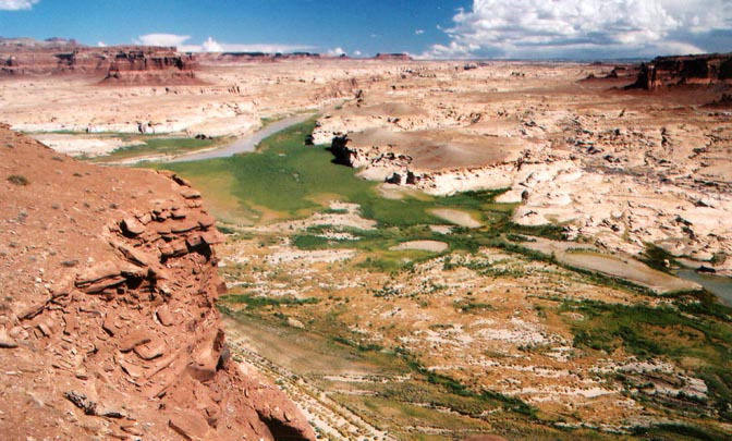
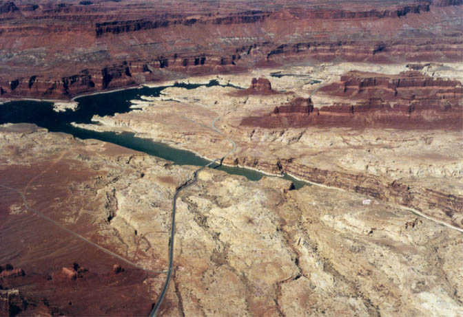
But in the late 1960s, plans were made to pave the entire Hanksville to Blanding Road. In addition they would have to find an alternative for the ferry. The waters of Lake Powell reached Hite by 1964. The ferry was gone. To replace this simple operation would not be easy. At pool level the lake would be too wide for a single bridge. And so UDOT devised a plan to connect the two sides of the river by constructing three new bridges. It was their only option. Coming from the east, the first formidable barrier was White Canyon. It was a narrow crossing but very, very deep. Once that obstacle was overcome, the new road descended toward the Colorado. At the point where Narrow Canyon meets the Glen, the largest of the three bridges crossed the Colorado River. Finally there was the Dirty Devil River to get over. Thus bridge number three.
When I first discovered the old Utah Hwy 95 in 1971, I was coming from the east and Blanding. The road stayed paved for just a few miles before it turned to dirt. I reached the top of the Comb Ridge Dugway, descended 2000 feet to the wash and then climbed out of the wooded verdant valley and onto Cedar Mesa. For a complete account of this story, read my account, “Live from Hadley Plain and Comb Wash.”
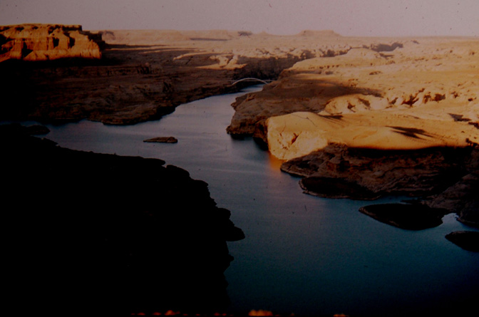
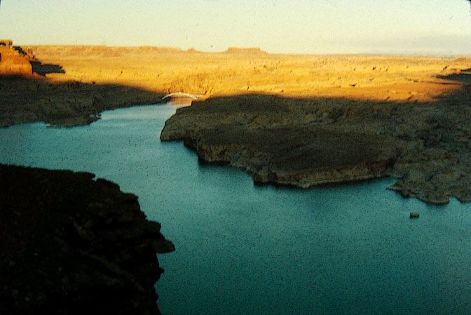
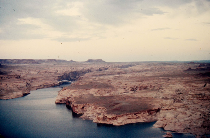
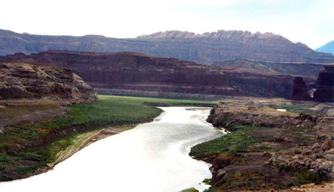
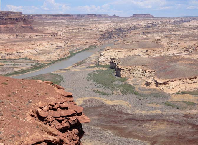
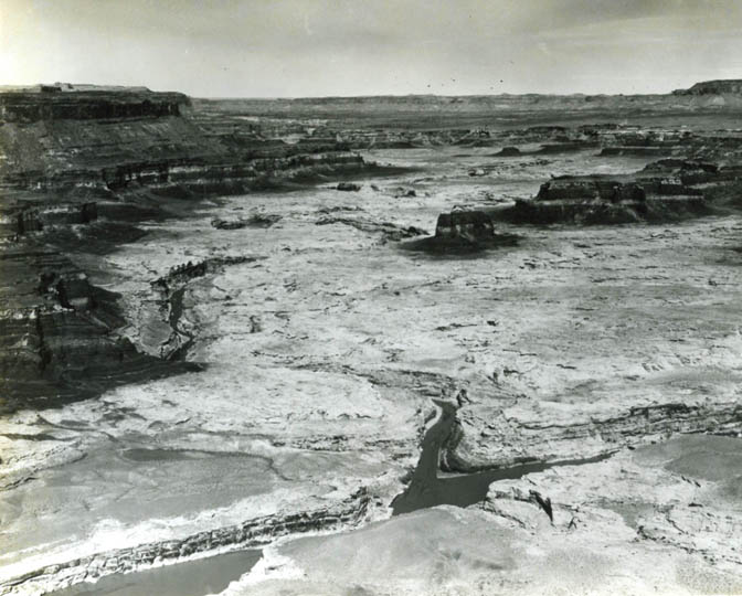
It was like another world, I saw no one. I camped near Natural Bridges and the next morning, crossed the three bridges and and ground my way up the steep incline on the west side to North Wash. But I saw a sign and hung a left to get an overview of the lake and the country I had just traversed. It was my first view from Hite Overlook. It was August 1, 1971. That drive changed my life. I had taken photos all along the 100 mile drive from Blanding, including the Overlook. But when I got back to Kentucky, on my first night home, someone broke into my VW Squareback on the U of L campus, and stole everything I owned. My clothes, my guitar, my camping gear…and five rolls of undeveloped Kodachrome film.I still grieve over those lost images.
Five months later, in early January I finally took my first image of the lake that I was able to hold on to. It was cold and clear and the road was dry. It was all just as I had remembered it.
August 2006
AND FINALLY…
TO LEAVE A COMMENT, DCROLL TO THE BOTTOM OF THIS PAGE. WE APPRECIATE YOUR OBSRVATIONSS

,

If you want to get on our email list, just write “sign me up” in the subject line and email it to: cczephyr@gmail.com


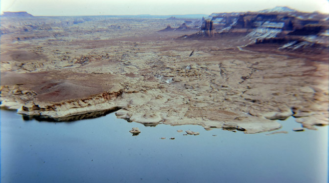
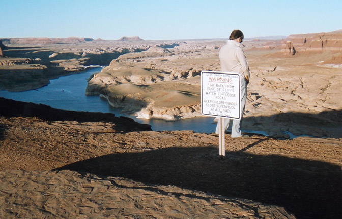
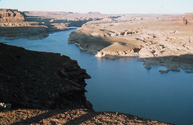
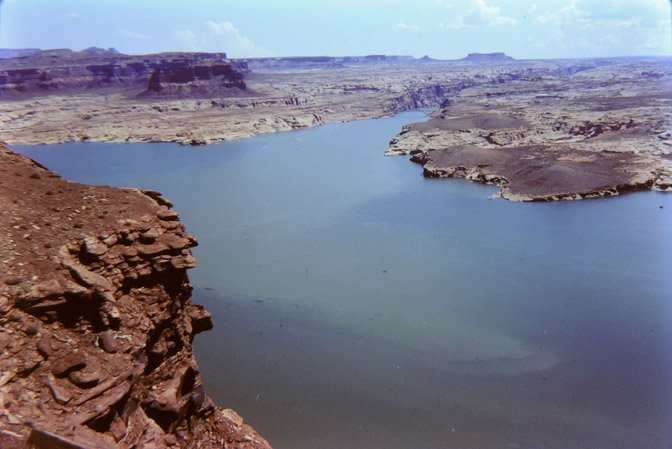
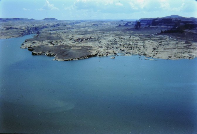
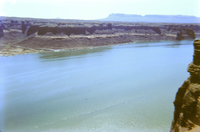
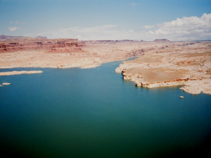
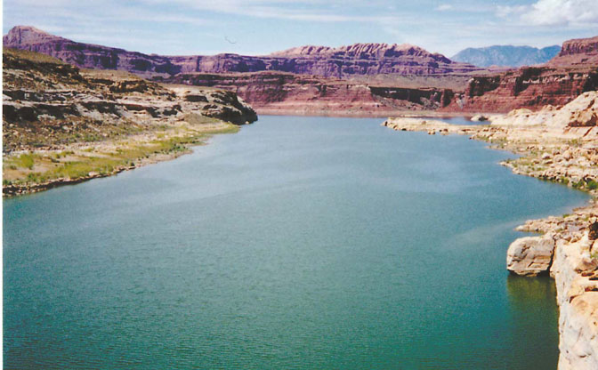
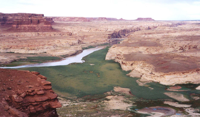
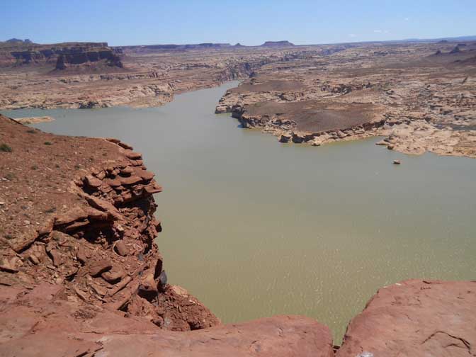
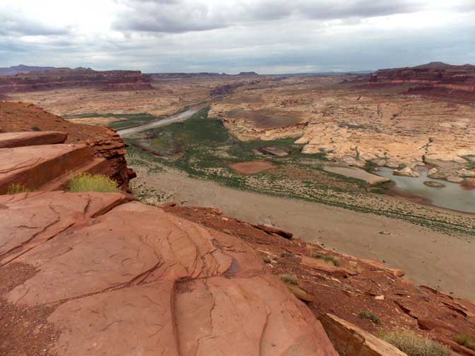
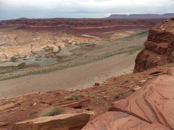
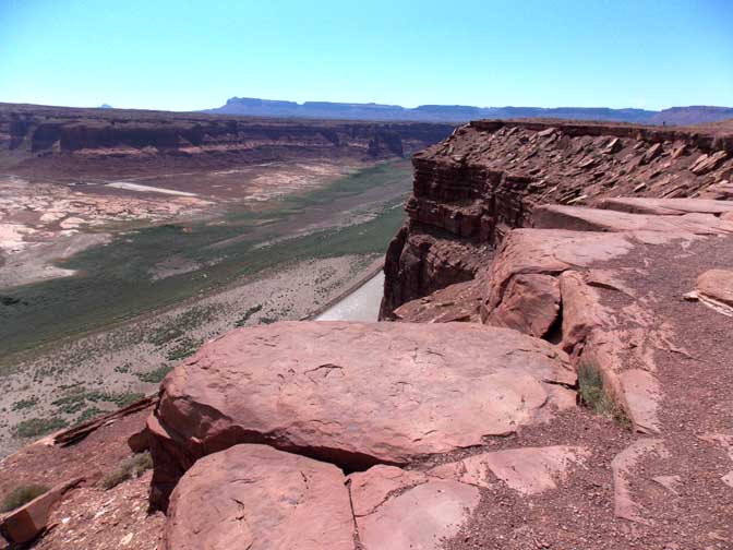
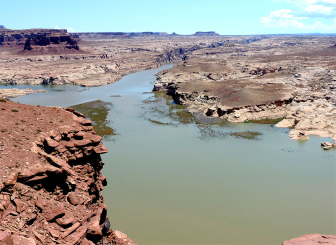
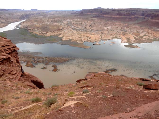
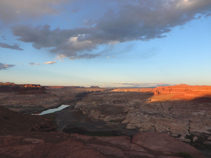
What a consistently rewarding overlook, after cannonballing down North Canyon. I can never stop myself from pulling off at the Hite Overlook, and no matter how much of a hurry I’m in I can get away in no less than 90 minutes or so, often two hours. The view changes a lot over seasons and years. For more striking photos of the changes in the prospects, see Annette McGivney’s and James Kay’s book Resurrection, which includes big prints of the Hite CrossIng through the later ’90s and into the 2000s. Even without shade on a hot day, the view is irresistable.
Excellent story and the pictures tell it all! Am forwarding this to friends who live in Page. this history is not well known and thank you for telling it! Most sincerely, Donna Like the cartoon of CJ and Gail
This is an incredible documentation of history and a fascinating way to present the critical issue of water in the west, aridification and climate change, and the consequences of man’s actions to control natural forces. I am eager to see the coming stories. Bravo!
What an interesting article and the photos are so good at telling the story of what has happened to the river and Lake Powell as seen from the overlook.
Great pictures, Stiles. Seeing the reservoir at, or near, full pool in the ‘Hite’ marina area is, simultaneously, fascinating and ghastly.
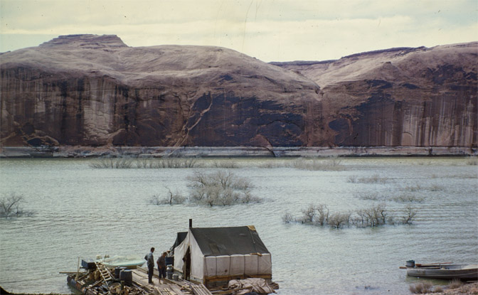
I believe the ferry between the real Hite, with Chaffin’s farm, and the settlement of White Canyon operated at an elevation of ~3443 feet above mean sea level and was inundated in June 1964 when the water was rising rather quickly.
However, by August 1964 – with the reservoir elevation at ~3485 – a temporary ferry was operating out of North Wash to a point on the opposite (east) bank close to where the future marina would have its southern (primative) ramp.
This ferry was operating on the flat waters of Powell and, therefore, needed no guide cables. Just a propeller and a skipper that knew the lie of the land.
For over a year, and with the water constantly rising, the operater of the ferry chased old 95 back up North Wash, at least until late-September 1965, to provide some access from the road that people were familiar with.
I have photos of this stop-gap ferry from both North Wash and the east side of the proto-reservoir but obviously can’t post them here.
Anyway, by ’66 the shiny new bridge was operational, the reservoir was half-full and everyone was happy.
P.S. Somewhat ironically, the later photos I’ve seen of the temporary ferry in North Wash, dated 21st September 1965, were taken when the reservoir was at an identical elevation to that of today: 3530 feet above mean sea level.
Now the flat water at 3530 is over ten miles downstream from where those 1965 photographs were taken.
As an aside, Jim: If you and your dodgy mates have been urinating off Hite overlook since 1971, can any of you remember when Hite marina came into being? When was the concrete for the ramp poured?
I know the first, basic, ‘Hite’ marina was set up in Glen Cove on the opposite side of the reservoir where, these days, the river runners haul their rigs out. The early marina was definitely in use from early ’66 until at least ’69.
At some point Glen Cove became impractical for the boat people and Hite marina on the east shore was brought into service. This must have been a smooth overlap considering how many dollars were riding on access to the far-north of the reservoir, surely?
So, do you, Stiles, or any of your other seven readers (that’s a little joke) know when the modern, now defunct, Hite marina on the eastern shore of Powell reservoir came ‘online’?
Thank you for these photos! Amazing to see them and compare them year to year. Worked at Hite in 1977 and the takeout for the river trips was right up at the boat ramp. With a little dock to tie up to as well. Are there and photos of the Marina as it was? Hard to find.
It’s very satisfying to see see the last couple of photos look so similar.
Thank you for this photo record and info. While I love the southwest rivers and high plateau everything about this impoundment has been very dispiriting to me. It would be renewing to see more of the old canyon become available again.
Wonderful history and photos. I have been to Lake Powell twice, 2004 and 2015. These photos and history are so valuable. Thanks for informing everyone who loves this place about the past and present. Ed Abbey would be so proud of you for doing this.
Incredible documentation, illustrates the issue better than anything I’ve seen.
A great visual story! I’ve been personally watching this unfold myself since 1970, when I worked my first season at Natural Bridges National Monument. And now I’m back working successive seasons there 52 years later. So I traveled those shiny bridges when they were only 4 years old.
I enjoyed your account in 1971 seeing the Comb Ridge Dugway for the first time. I wonder if we met that summer. My bride was freaked the first time we went over it, but she got used to it quickly enough. Considering that the Moki Dugway, almost as thrilling, was the other major access route, we rangers at the Bridges would greet the incoming visitors, some still shaking, and when they would ask “Is there a better road out of here”, we’d ask them “Which road did you come in on?” Not what they wanted to hear.
As for the Lake, which I do not miss, I took my first backpack trip into lower Dark Canyon in 1981, where our group was picked up by a concession boat for transportation to Hite. That was repeated in 1983 and 1985, as I assumed leadership of those trips. My next one was 1989; this time we exited by the Sundance Trail, but not before hiking to the mouth of Dark Canyon. The river was flowing serenely past. No boat pickup this time. Incidentally, I missed seeing Colin Fletcher, author of “River” by 2 or 3 days as he journeyed out of Cataract Canyon that year.
And the Lake has never penetrated Dark Canyon since! And, honestly, despite the silt, I enjoy looking downriver from Hite as far as I can see, and dreaming of the unearthing history that is reappearing beyond my sight. Looking forward to your next “Hite” article.
Jim, you mentioned Barbara Ekker of Hanksville. In your archives do you have any interviews with her? I only met her a couple of times, but found her an effervescent font of local information, history, and gossip. I hope it didn’t all go to her grave. Thanks for this photo series, which I found very interesting.
I think it funny that so often the opposition to a project miss the real reason for opposition, For example, there was much chin-wagging about the silt buildup in the lake. It turned out that the real problem was drought. Another example, there was much wailing about greenhouse gasses and the wickedness of coal. True enough, but what would largely kill it would be economics. (Of course, short-sighted policies in Europe have temporarily reversed that!)
I played a lot of music with Will Barclay. His grandfather was Arth Chaffin and Will lives in Arth’s old Teasdale house. Will had lots of stories about Arthur and he gave me a box of Arth’s old paperwork. Included was a letter Arth sent to the feds, trying to get some graves moved as lake foul came to be. My song Pirates Of The Colorado came directly from stuff Arth had written…
Great work Jim! Thank you for doing this. Cordially yours, Tom
Before many blame this climate change fully on anthroprogenic creation and that we must all give up our rights and soverignty to global banksters and UN globalists I urge caution. I sat as a panelist and guest speaker in 1990 with the Aspen Institute and CFR member, Dr. William W. Kellogg who co wrote one of the seminal books on climate and society. A fellow CFR member, Tim Wirth, told a reporter that year, “We have to ride the global warming issue. Even if the theory of global warming is wrong, we will be doing the right thing in terms of economic policy and environmental policy.”
I bring it up as a person having a broad natural resources science background as well as one who studied as a minor, geography. Humans role in changing the face of the earth has been a constant in 6,000 years as well as their adaptations. Global warming theory and models have been proferred to the global community in an effort imo to cause panic and undermine national soverignty and our Bill of Rights to groups like the WEF (who I call the World Enslavement Forum) It doesn’t have to go that way.
A 50% reduction in human carbon-energy use can be achieved without them with a good monthly fee and dividend system in place. With a bit of education I trust many to make good decisions. The elites of Davos don’t like that approach because it moves much of the control back to the public.
The current projections of global energy use FYI, with the “Great Reset”, is showing no real reductions past 2050. If this is catastrophic I can say that it happened before to many cultures across this planet. Just look at the Anazasi, the Sahara and more. Read works by George Perkins Marsh. It has happened before.